Saint-Dézéry
| Saint-Dézéry | ||
|---|---|---|
| Commune | ||
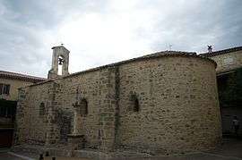 The church of Saint-Dézéry | ||
| ||
 Saint-Dézéry Location within Occitanie region  Saint-Dézéry | ||
| Coordinates: 44°00′07″N 4°16′14″E / 44.0019°N 4.2706°ECoordinates: 44°00′07″N 4°16′14″E / 44.0019°N 4.2706°E | ||
| Country | France | |
| Region | Occitanie | |
| Department | Gard | |
| Arrondissement | Nîmes | |
| Canton | Uzès | |
| Government | ||
| • Mayor (2001–2008) | Frédéric Platon | |
| Area1 | 6.01 km2 (2.32 sq mi) | |
| Population (2008)2 | 362 | |
| • Density | 60/km2 (160/sq mi) | |
| Time zone | UTC+1 (CET) | |
| • Summer (DST) | UTC+2 (CEST) | |
| INSEE/Postal code | 30248 /30190 | |
| Elevation |
81–196 m (266–643 ft) (avg. 70 m or 230 ft) | |
|
1 French Land Register data, which excludes lakes, ponds, glaciers > 1 km2 (0.386 sq mi or 247 acres) and river estuaries. 2 Population without double counting: residents of multiple communes (e.g., students and military personnel) only counted once. | ||
.svg.png)
Saint-Dézéry is a commune in the Gard department in southern France.
Population
| Historical population | ||
|---|---|---|
| Year | Pop. | ±% |
| 1962 | 151 | — |
| 1968 | 158 | +4.6% |
| 1975 | 138 | −12.7% |
| 1982 | 146 | +5.8% |
| 1990 | 220 | +50.7% |
| 1999 | 248 | +12.7% |
| 2008 | 362 | +46.0% |
See also
References
| Wikimedia Commons has media related to Saint-Dézéry. |
This article is issued from
Wikipedia.
The text is licensed under Creative Commons - Attribution - Sharealike.
Additional terms may apply for the media files.