Saint-Privat-des-Vieux
| Saint-Privat-des-Vieux | ||
|---|---|---|
| Commune | ||
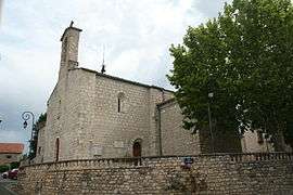 The church of Saint-Privat-des-Vieux | ||
| ||
 Saint-Privat-des-Vieux Location within Occitanie region  Saint-Privat-des-Vieux | ||
| Coordinates: 44°08′42″N 4°07′48″E / 44.145°N 4.13°ECoordinates: 44°08′42″N 4°07′48″E / 44.145°N 4.13°E | ||
| Country | France | |
| Region | Occitanie | |
| Department | Gard | |
| Arrondissement | Alès | |
| Canton | Alès-2 | |
| Intercommunality | Grand Alès | |
| Government | ||
| • Mayor (2008–2014) | Philippe Ribot | |
| Area1 | 15.8 km2 (6.1 sq mi) | |
| Population (2008)2 | 4,372 | |
| • Density | 280/km2 (720/sq mi) | |
| Time zone | UTC+1 (CET) | |
| • Summer (DST) | UTC+2 (CEST) | |
| INSEE/Postal code | 30294 /30340 | |
| Elevation |
129–285 m (423–935 ft) (avg. 204 m or 669 ft) | |
|
1 French Land Register data, which excludes lakes, ponds, glaciers > 1 km2 (0.386 sq mi or 247 acres) and river estuaries. 2 Population without double counting: residents of multiple communes (e.g., students and military personnel) only counted once. | ||
.svg.png)
Saint-Privat-des-Vieux is a commune in the Gard department in southern France.
Population
| Historical population | ||
|---|---|---|
| Year | Pop. | ±% |
| 1793 | 750 | — |
| 1821 | 508 | −32.3% |
| 1846 | 769 | +51.4% |
| 1872 | 906 | +17.8% |
| 1901 | 1,048 | +15.7% |
| 1911 | 1,144 | +9.2% |
| 1921 | 1,244 | +8.7% |
| 1926 | 1,348 | +8.4% |
| 1931 | 1,353 | +0.4% |
| 1936 | 1,268 | −6.3% |
| 1946 | 1,332 | +5.0% |
| 1954 | 1,432 | +7.5% |
| 1962 | 1,651 | +15.3% |
| 1968 | 2,020 | +22.4% |
| 1975 | 2,608 | +29.1% |
| 1982 | 3,345 | +28.3% |
| 1990 | 3,892 | +16.4% |
| 1999 | 4,064 | +4.4% |
| 2008 | 4,372 | +7.6% |
See also
References
| Wikimedia Commons has media related to Saint-Privat-des-Vieux. |
This article is issued from
Wikipedia.
The text is licensed under Creative Commons - Attribution - Sharealike.
Additional terms may apply for the media files.