Saint-Privat-de-Champclos
| Saint-Privat-de-Champclos | ||
|---|---|---|
| Commune | ||
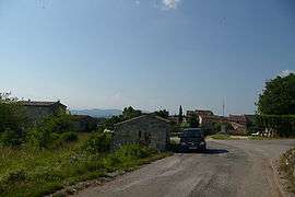 A general view of Saint-Privat-de-Champclos | ||
| ||
 Saint-Privat-de-Champclos Location within Occitanie region  Saint-Privat-de-Champclos | ||
| Coordinates: 44°17′09″N 4°21′31″E / 44.2858°N 4.3586°ECoordinates: 44°17′09″N 4°21′31″E / 44.2858°N 4.3586°E | ||
| Country | France | |
| Region | Occitanie | |
| Department | Gard | |
| Arrondissement | Alès | |
| Canton | Rousson | |
| Intercommunality | Pays de Cèze | |
| Government | ||
| • Mayor (2008–2014) | Bernard Raoux | |
| Area1 | 11.64 km2 (4.49 sq mi) | |
| Population (2008)2 | 305 | |
| • Density | 26/km2 (68/sq mi) | |
| Time zone | UTC+1 (CET) | |
| • Summer (DST) | UTC+2 (CEST) | |
| INSEE/Postal code | 30293 /30430 | |
| Elevation |
90–279 m (295–915 ft) (avg. 250 m or 820 ft) | |
|
1 French Land Register data, which excludes lakes, ponds, glaciers > 1 km2 (0.386 sq mi or 247 acres) and river estuaries. 2 Population without double counting: residents of multiple communes (e.g., students and military personnel) only counted once. | ||
.svg.png)
Saint-Privat-de-Champclos is a commune in the Gard department in southern France.
Population
| Historical population | ||
|---|---|---|
| Year | Pop. | ±% |
| 1793 | 506 | — |
| 1821 | 496 | −2.0% |
| 1846 | 602 | +21.4% |
| 1872 | 540 | −10.3% |
| 1901 | 390 | −27.8% |
| 1926 | 289 | −25.9% |
| 1946 | 247 | −14.5% |
| 1962 | 136 | −44.9% |
| 1968 | 173 | +27.2% |
| 1975 | 173 | +0.0% |
| 1982 | 189 | +9.2% |
| 1990 | 212 | +12.2% |
| 1999 | 203 | −4.2% |
| 2008 | 305 | +50.2% |
See also
References
| Wikimedia Commons has media related to Saint-Privat-de-Champclos. |
This article is issued from
Wikipedia.
The text is licensed under Creative Commons - Attribution - Sharealike.
Additional terms may apply for the media files.