Martignargues
| Martignargues | ||
|---|---|---|
| Commune | ||
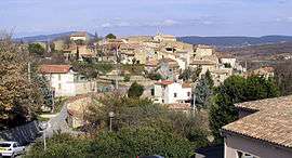 A general view of Martignargues | ||
| ||
 Martignargues Location within Occitanie region  Martignargues | ||
| Coordinates: 44°02′45″N 4°10′44″E / 44.0458°N 4.1789°ECoordinates: 44°02′45″N 4°10′44″E / 44.0458°N 4.1789°E | ||
| Country | France | |
| Region | Occitanie | |
| Department | Gard | |
| Arrondissement | Alès | |
| Canton | Alès-3 | |
| Intercommunality | Région de Vézénobres | |
| Government | ||
| • Mayor (2008–2014) | Alain Reynaud | |
| Area1 | 4.92 km2 (1.90 sq mi) | |
| Population (2008)2 | 383 | |
| • Density | 78/km2 (200/sq mi) | |
| Time zone | UTC+1 (CET) | |
| • Summer (DST) | UTC+2 (CEST) | |
| INSEE/Postal code | 30158 /30360 | |
| Elevation | 88–172 m (289–564 ft) | |
|
1 French Land Register data, which excludes lakes, ponds, glaciers > 1 km2 (0.386 sq mi or 247 acres) and river estuaries. 2 Population without double counting: residents of multiple communes (e.g., students and military personnel) only counted once. | ||
.svg.png)
Martignargues is a commune in the Gard department in southern France.
Population
| Historical population | ||
|---|---|---|
| Year | Pop. | ±% |
| 1793 | 96 | — |
| 1821 | 142 | +47.9% |
| 1846 | 136 | −4.2% |
| 1872 | 192 | +41.2% |
| 1901 | 153 | −20.3% |
| 1926 | 133 | −13.1% |
| 1946 | 127 | −4.5% |
| 1962 | 139 | +9.4% |
| 1968 | 145 | +4.3% |
| 1975 | 145 | +0.0% |
| 1982 | 208 | +43.4% |
| 1990 | 241 | +15.9% |
| 1999 | 240 | −0.4% |
| 2008 | 383 | +59.6% |
See also
References
| Wikimedia Commons has media related to Martignargues. |
This article is issued from
Wikipedia.
The text is licensed under Creative Commons - Attribution - Sharealike.
Additional terms may apply for the media files.