Saint-Julien-de-Peyrolas
| Saint-Julien-de-Peyrolas | ||
|---|---|---|
| Commune | ||
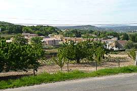 A general view of Saint-Julien-de-Peyrolas | ||
| ||
 Saint-Julien-de-Peyrolas Location within Occitanie region  Saint-Julien-de-Peyrolas | ||
| Coordinates: 44°17′19″N 4°33′57″E / 44.2886°N 4.5658°ECoordinates: 44°17′19″N 4°33′57″E / 44.2886°N 4.5658°E | ||
| Country | France | |
| Region | Occitanie | |
| Department | Gard | |
| Arrondissement | Nîmes | |
| Canton | Pont-Saint-Esprit | |
| Intercommunality | ValCezArd | |
| Government | ||
| • Mayor (2008–2014) | Christiane Bremond | |
| Area1 | 12.54 km2 (4.84 sq mi) | |
| Population (2008)2 | 1,223 | |
| • Density | 98/km2 (250/sq mi) | |
| Time zone | UTC+1 (CET) | |
| • Summer (DST) | UTC+2 (CEST) | |
| INSEE/Postal code | 30273 /30760 | |
| Elevation |
54–211 m (177–692 ft) (avg. 196 m or 643 ft) | |
|
1 French Land Register data, which excludes lakes, ponds, glaciers > 1 km2 (0.386 sq mi or 247 acres) and river estuaries. 2 Population without double counting: residents of multiple communes (e.g., students and military personnel) only counted once. | ||
.svg.png)
Saint-Julien-de-Peyrolas is a commune in the Gard department in southern France.
Population
| Historical population | ||
|---|---|---|
| Year | Pop. | ±% |
| 1962 | 667 | — |
| 1968 | 667 | +0.0% |
| 1975 | 652 | −2.2% |
| 1982 | 711 | +9.0% |
| 1990 | 1,088 | +53.0% |
| 1999 | 1,103 | +1.4% |
| 2008 | 1,223 | +10.9% |
See also
References
| Wikimedia Commons has media related to Saint-Julien-de-Peyrolas. |
This article is issued from
Wikipedia.
The text is licensed under Creative Commons - Attribution - Sharealike.
Additional terms may apply for the media files.