Nages-et-Solorgues
| Nages-et-Solorgues | ||
|---|---|---|
| Commune | ||
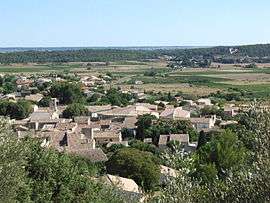 A general view of Nages | ||
| ||
 Nages-et-Solorgues Location within Occitanie region  Nages-et-Solorgues | ||
| Coordinates: 43°47′30″N 4°13′51″E / 43.7917°N 4.2308°ECoordinates: 43°47′30″N 4°13′51″E / 43.7917°N 4.2308°E | ||
| Country | France | |
| Region | Occitanie | |
| Department | Gard | |
| Arrondissement | Nîmes | |
| Canton | Calvisson | |
| Intercommunality | Rhôny Vistre Vidourle | |
| Government | ||
| • Mayor (2008–2014) | Jean-Baptiste Esteve | |
| Area1 | 6.18 km2 (2.39 sq mi) | |
| Population (2008)2 | 1,510 | |
| • Density | 240/km2 (630/sq mi) | |
| Time zone | UTC+1 (CET) | |
| • Summer (DST) | UTC+2 (CEST) | |
| INSEE/Postal code | 30186 /30114 | |
| Elevation |
31–174 m (102–571 ft) (avg. 42 m or 138 ft) | |
|
1 French Land Register data, which excludes lakes, ponds, glaciers > 1 km2 (0.386 sq mi or 247 acres) and river estuaries. 2 Population without double counting: residents of multiple communes (e.g., students and military personnel) only counted once. | ||

Nages-et-Solorgues is a commune in the Gard department in southern France.
Population
| Historical population | ||
|---|---|---|
| Year | Pop. | ±% |
| 1962 | 278 | — |
| 1968 | 327 | +17.6% |
| 1975 | 451 | +37.9% |
| 1982 | 715 | +58.5% |
| 1990 | 1,088 | +52.2% |
| 1999 | 1,295 | +19.0% |
| 2008 | 1,510 | +16.6% |
See also
References
| Wikimedia Commons has media related to Nages-et-Solorgues. |
This article is issued from
Wikipedia.
The text is licensed under Creative Commons - Attribution - Sharealike.
Additional terms may apply for the media files.