Bourdic
| Bourdic | ||
|---|---|---|
| Commune | ||
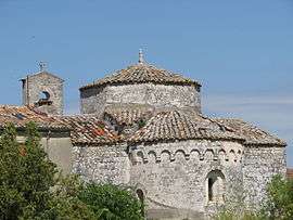 The church of Bourdic | ||
| ||
 Bourdic Location within Occitanie region  Bourdic | ||
| Coordinates: 43°59′03″N 4°19′52″E / 43.9842°N 4.3311°ECoordinates: 43°59′03″N 4°19′52″E / 43.9842°N 4.3311°E | ||
| Country | France | |
| Region | Occitanie | |
| Department | Gard | |
| Arrondissement | Nîmes | |
| Canton | Uzès | |
| Government | ||
| • Mayor (2008–2014) | Christophe Gervais | |
| Area1 | 7.34 km2 (2.83 sq mi) | |
| Population (2008)2 | 334 | |
| • Density | 46/km2 (120/sq mi) | |
| Time zone | UTC+1 (CET) | |
| • Summer (DST) | UTC+2 (CEST) | |
| INSEE/Postal code | 30049 /30190 | |
| Elevation |
69–110 m (226–361 ft) (avg. 86 m or 282 ft) | |
|
1 French Land Register data, which excludes lakes, ponds, glaciers > 1 km2 (0.386 sq mi or 247 acres) and river estuaries. 2 Population without double counting: residents of multiple communes (e.g., students and military personnel) only counted once. | ||
.svg.png)
Bourdic is a commune in the Gard department in southern France. The village is part of greater Nîmes.
Population
| Historical population | ||
|---|---|---|
| Year | Pop. | ±% |
| 1962 | 206 | — |
| 1968 | 208 | +1.0% |
| 1975 | 202 | −2.9% |
| 1982 | 211 | +4.5% |
| 1990 | 236 | +11.8% |
| 1999 | 262 | +11.0% |
| 2008 | 334 | +27.5% |
Wine
The village is entirely orientated on vineyards. On one hand, the biggest wine coop of the department Gard is situated in the centre of Bourdic. The village also has two private wineries. The labels are Collines de Bourdic, Domaine Chabrier, and Domaine Perdrix-Lasouche.
See also
References
External links
| Wikimedia Commons has media related to Bourdic. |
- More statistical information on the village on www.insee.fr
- Winery Perdrix-Lasouche :
This article is issued from
Wikipedia.
The text is licensed under Creative Commons - Attribution - Sharealike.
Additional terms may apply for the media files.