Les Angles, Gard
| Les Angles | ||
|---|---|---|
| Commune | ||
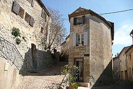 Old town | ||
| ||
 Les Angles Location within Occitanie region  Les Angles | ||
| Coordinates: 43°57′19″N 4°46′02″E / 43.9553°N 4.7672°ECoordinates: 43°57′19″N 4°46′02″E / 43.9553°N 4.7672°E | ||
| Country | France | |
| Region | Occitanie | |
| Department | Gard | |
| Arrondissement | Nîmes | |
| Canton | Villeneuve-lès-Avignon | |
| Intercommunality | CA Grand Avignon | |
| Government | ||
| • Mayor (2008–2014) | Jean-Louis Banino | |
| Area1 | 17.77 km2 (6.86 sq mi) | |
| Population (2008)2 | 8,269 | |
| • Density | 470/km2 (1,200/sq mi) | |
| Time zone | UTC+1 (CET) | |
| • Summer (DST) | UTC+2 (CEST) | |
| INSEE/Postal code | 30011 /30133 | |
| Elevation |
10–183 m (33–600 ft) (avg. 60 m or 200 ft) | |
|
1 French Land Register data, which excludes lakes, ponds, glaciers > 1 km2 (0.386 sq mi or 247 acres) and river estuaries. 2 Population without double counting: residents of multiple communes (e.g., students and military personnel) only counted once. | ||
.svg.png)
Les Angles is a commune in the Gard department in southern France.
Population
| Historical population | ||
|---|---|---|
| Year | Pop. | ±% |
| 1962 | 2,728 | — |
| 1968 | 3,505 | +28.5% |
| 1975 | 4,582 | +30.7% |
| 1982 | 5,570 | +21.6% |
| 1990 | 6,838 | +22.8% |
| 1999 | 7,578 | +10.8% |
| 2008 | 8,269 | +9.1% |
See also
References
| Wikimedia Commons has media related to Les Angles, Gard. |
This article is issued from
Wikipedia.
The text is licensed under Creative Commons - Attribution - Sharealike.
Additional terms may apply for the media files.