Gard
| Gard | |||
|---|---|---|---|
| Department | |||
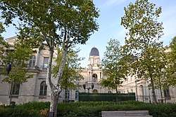 Prefecture building of the Gard department, in Nîmes | |||
| |||
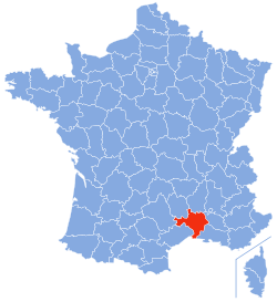 Location of Gard in France | |||
| Coordinates: 44°7′41″N 4°4′54″E / 44.12806°N 4.08167°ECoordinates: 44°7′41″N 4°4′54″E / 44.12806°N 4.08167°E | |||
| Country | France | ||
| Region | Occitanie | ||
| Prefecture | Nîmes | ||
| Subprefectures |
Alès Le Vigan | ||
| Government | |||
| • President of the General Council | Jean Denat (PS) | ||
| Area1 | |||
| • Total | 5,853 km2 (2,260 sq mi) | ||
| Population (2013) | |||
| • Total | 733,201 | ||
| • Rank | 32nd | ||
| • Density | 130/km2 (320/sq mi) | ||
| Time zone | UTC+1 (CET) | ||
| • Summer (DST) | UTC+2 (CEST) | ||
| Department number | 30 | ||
| Arrondissements | 3 | ||
| Cantons | 23 | ||
| Communes | 353 | ||
| ^1 French Land Register data, which exclude estuaries, and lakes, ponds, and glaciers larger than 1 km2 | |||


Gard (French pronunciation: [ɡaʁ]; Occitan: Gard [gaɾ]) is a department in southern France in the Occitanie region.
The department is named after the River Gardon, and the Occitan name of the river has been replacing the French name of the department in recent decades, even among French speakers.
History
See also: History of Gard
The Gard area was settled by the Romans in classical times. It was crossed by the Via Domitia, which was constructed in 118 BC.
Gard is one of the original 83 departments created during the French Revolution on March 4, 1790. It was created from the ancient province of Languedoc.
It was originally intended to include the canton of Ganges in the department which would have been geographically logical, but Ganges was transferred to the neighbouring department of Hérault at the outset. In return, Gard received from Hérault the fishing port of Aigues Mortes which gave the department its own outlet to the Gulf of Lion.
During the middle of the nineteenth century the prefecture, traditionally a centre of commerce with a manufacturing sector focused on textiles, was an early beneficiary of railway development, becoming an important railway junction. Several luxurious hotels were built, and the improved market access provided by the railways also encouraged, initially, a rapid growth in wine growing: however, many of the department's viticulturalists were ruined by the arrival in 1872 of phylloxera.
Geography
.JPG)
Gard is part of the region of Occitanie and is surrounded by the departments of Hérault, Lozère, Aveyron, Bouches-du-Rhône, Vaucluse, and Ardèche. The highest point in the department is the Mont Aigoual. Serious flooding has occurred in the department in recent years.
Politics
The President of the General Council is Denis Bouad of the Socialist Party (PS).
| Party | Seats | |
|---|---|---|
| The Republicans (LR) | 12 | |
| • | Socialist Party (PS) | 10 |
| Union of Democrats and Independents (UDI) | 7 | |
| • | French Communist Party (PCF) | 6 |
| • | Miscellaneous left (DVG) | 4 |
| National Front (FN) | 4 | |
| • | Europe Ecology – The Greens (EELV) | 2 |
| Miscellaneous right (DVD) | 1 | |
In the closely contested first round of the 2012 French presidential election, Gard was the only department to vote for the National Front candidate Marine Le Pen by a slim plurality, with 25.51% of the vote. The incumbent President Nicolas Sarkozy of the Union for a Popular Movement party received 24.86% of the vote, while Socialist candidate François Hollande received 24.11% of the vote share.[1]
Demographics
The inhabitants of Gard are called "Gardois". In 2012, the population of Gard was 694,323 with 8 towns having more than 10,000 inhabitants :
| Town | Population |
|---|---|
| Nîmes | 146 709 |
| Alès | 41 031 |
| Bagnols-sur-Cèze | 18 375 |
| Beaucaire | 15 860 |
| Saint-Gilles | 13 646 |
| Villeneuve-lès-Avignon | 12 232 |
| Vauvert | 11 261 |
| Pont-Saint-Esprit | 10 651 |
See also
References
- ↑ "Résultats Gard - Présidentielle 2012 - 1er et 2nd tour". Le Monde.fr. Retrieved 1 April 2018.
Tourism and points of interest
Gard contains a part of the Cévennes National Park.
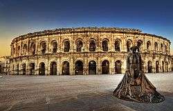
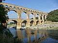
There are important Roman architectural remains in Nîmes, as well as the famous Roman aqueduct, the Pont du Gard.
Gard is also home to the source of Perrier, a carbonated mineral water sold both in France and internationally on a large scale. The spring and facility are located just south-east of the commune of Vergèze.
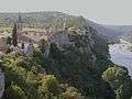
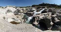 Cèze rapids
External links
| Wikimedia Commons has media related to Gard. |

- (in French) Prefecture website
- (in French) General Council website
- (in French) Welcome to the Gard
- (in English) Welcome to the Gard
- (English and French) The Regordane Way or St Gilles Trail
- Map of the department
- (in French) Guide Gard