Deaux
| Deaux | ||
|---|---|---|
| Commune | ||
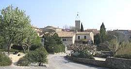 View from the city hall | ||
| ||
 Deaux Location within Occitanie region  Deaux | ||
| Coordinates: 44°04′03″N 4°09′03″E / 44.0675°N 4.1508°ECoordinates: 44°04′03″N 4°09′03″E / 44.0675°N 4.1508°E | ||
| Country | France | |
| Region | Occitanie | |
| Department | Gard | |
| Arrondissement | Alès | |
| Canton | Alès-3 | |
| Intercommunality | Région de Vézénobres | |
| Government | ||
| • Mayor (2001–2008) | François Ferrier | |
| Area1 | 5.95 km2 (2.30 sq mi) | |
| Population (2008)2 | 577 | |
| • Density | 97/km2 (250/sq mi) | |
| Time zone | UTC+1 (CET) | |
| • Summer (DST) | UTC+2 (CEST) | |
| INSEE/Postal code | 30101 / | |
| Dialling codes | 046683 | |
| Elevation |
103–198 m (338–650 ft) (avg. 110 m or 360 ft) | |
|
1 French Land Register data, which excludes lakes, ponds, glaciers > 1 km2 (0.386 sq mi or 247 acres) and river estuaries. 2 Population without double counting: residents of multiple communes (e.g., students and military personnel) only counted once. | ||
.svg.png)
Deaux is a small, wooded commune in the Gard department in southern France.
Population
| Historical population | ||
|---|---|---|
| Year | Pop. | ±% |
| 1793 | 199 | — |
| 1821 | 190 | −4.5% |
| 1846 | 227 | +19.5% |
| 1872 | 148 | −34.8% |
| 1901 | 132 | −10.8% |
| 1926 | 114 | −13.6% |
| 1946 | 105 | −7.9% |
| 1962 | 125 | +19.0% |
| 1968 | 97 | −22.4% |
| 1975 | 174 | +79.4% |
| 1982 | 288 | +65.5% |
| 1990 | 390 | +35.4% |
| 1999 | 476 | +22.1% |
| 2008 | 577 | +21.2% |
See also
References
| Wikimedia Commons has media related to Deaux. |
This article is issued from
Wikipedia.
The text is licensed under Creative Commons - Attribution - Sharealike.
Additional terms may apply for the media files.