Gajan, Gard
| Gajan | ||
|---|---|---|
| Commune | ||
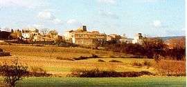 A general view of Gajan | ||
| ||
 Gajan Location within Occitanie region  Gajan | ||
| Coordinates: 43°53′52″N 4°12′56″E / 43.8978°N 4.2156°ECoordinates: 43°53′52″N 4°12′56″E / 43.8978°N 4.2156°E | ||
| Country | France | |
| Region | Occitanie | |
| Department | Gard | |
| Arrondissement | Nîmes | |
| Canton | Calvisson | |
| Intercommunality | CA Nîmes Métropole | |
| Government | ||
| • Mayor (2008–2014) | Renaud Andre | |
| Area1 | 10.91 km2 (4.21 sq mi) | |
| Population (2008)2 | 691 | |
| • Density | 63/km2 (160/sq mi) | |
| Time zone | UTC+1 (CET) | |
| • Summer (DST) | UTC+2 (CEST) | |
| INSEE/Postal code | 30122 /30730 | |
| Elevation |
79–165 m (259–541 ft) (avg. 98 m or 322 ft) | |
|
1 French Land Register data, which excludes lakes, ponds, glaciers > 1 km2 (0.386 sq mi or 247 acres) and river estuaries. 2 Population without double counting: residents of multiple communes (e.g., students and military personnel) only counted once. | ||
.svg.png)
Gajan is a commune in the Gard department in southern France.
Population
| Historical population | ||
|---|---|---|
| Year | Pop. | ±% |
| 1901 | 301 | — |
| 1907 | 242 | −19.6% |
| 1911 | 295 | +21.9% |
| 1919 | 277 | −6.1% |
| 1926 | 309 | +11.6% |
| 1943 | 209 | −32.4% |
| 1962 | 247 | +18.2% |
| 1968 | 247 | +0.0% |
| 1975 | 247 | +0.0% |
| 1982 | 314 | +27.1% |
| 1990 | 459 | +46.2% |
| 1999 | 633 | +37.9% |
| 2008 | 691 | +9.2% |
See also
References
| Wikimedia Commons has media related to Gajan (Gard). |
This article is issued from
Wikipedia.
The text is licensed under Creative Commons - Attribution - Sharealike.
Additional terms may apply for the media files.