Vers-Pont-du-Gard
| Vers-Pont-du-Gard | ||
|---|---|---|
| Commune | ||
 | ||
| ||
 Vers-Pont-du-Gard Location within Occitanie region  Vers-Pont-du-Gard | ||
| Coordinates: 43°58′10″N 4°31′30″E / 43.9694°N 4.525°ECoordinates: 43°58′10″N 4°31′30″E / 43.9694°N 4.525°E | ||
| Country | France | |
| Region | Occitanie | |
| Department | Gard | |
| Arrondissement | Nîmes | |
| Canton | Redessan | |
| Intercommunality | Pont du Gard | |
| Government | ||
| • Mayor (2008–2014) | Marc Poulon | |
| Area1 | 19.14 km2 (7.39 sq mi) | |
| Population (2008)2 | 1,653 | |
| • Density | 86/km2 (220/sq mi) | |
| Time zone | UTC+1 (CET) | |
| • Summer (DST) | UTC+2 (CEST) | |
| INSEE/Postal code | 30346 /30210 | |
| Elevation |
15–192 m (49–630 ft) (avg. 52 m or 171 ft) | |
|
1 French Land Register data, which excludes lakes, ponds, glaciers > 1 km2 (0.386 sq mi or 247 acres) and river estuaries. 2 Population without double counting: residents of multiple communes (e.g., students and military personnel) only counted once. | ||
.svg.png)
Vers-Pont-du-Gard (Vèrs in Occitan) is a commune in the Gard department in southern France.
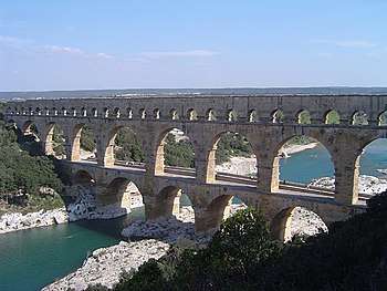
The Pont du Gard is located on the territory of the commune.
Gallery
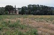 Chapelle Saint-Pierre
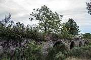 Ancient Roman aqueduct.
Population
| Historical population | ||
|---|---|---|
| Year | Pop. | ±% |
| 1962 | 603 | — |
| 1968 | 644 | +6.8% |
| 1975 | 739 | +14.8% |
| 1982 | 924 | +25.0% |
| 1990 | 1,110 | +20.1% |
| 1999 | 1,322 | +19.1% |
| 2008 | 1,653 | +25.0% |
International relations
Vers-Pont-du-Gard is twinned with:
See also
References
External links
| Wikimedia Commons has media related to Vers-Pont-du-Gard. |
This article is issued from
Wikipedia.
The text is licensed under Creative Commons - Attribution - Sharealike.
Additional terms may apply for the media files.