Castelnau-Valence
| Castelnau-Valence | ||
|---|---|---|
| Commune | ||
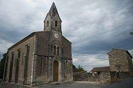 The Protestant church of Castelnau-Valence | ||
| ||
 Castelnau-Valence Location within Occitanie region  Castelnau-Valence | ||
| Coordinates: 44°00′35″N 4°15′10″E / 44.0097°N 4.2528°ECoordinates: 44°00′35″N 4°15′10″E / 44.0097°N 4.2528°E | ||
| Country | France | |
| Region | Occitanie | |
| Department | Gard | |
| Arrondissement | Alès | |
| Canton | Alès-3 | |
| Intercommunality | Région de Vézénobres | |
| Government | ||
| • Mayor (2008–2014) | Christophe Bougarel | |
| Area1 | 10.27 km2 (3.97 sq mi) | |
| Population (2008)2 | 354 | |
| • Density | 34/km2 (89/sq mi) | |
| Time zone | UTC+1 (CET) | |
| • Summer (DST) | UTC+2 (CEST) | |
| INSEE/Postal code | 30072 /30190 | |
| Elevation |
89–196 m (292–643 ft) (avg. 150 m or 490 ft) | |
|
1 French Land Register data, which excludes lakes, ponds, glaciers > 1 km2 (0.386 sq mi or 247 acres) and river estuaries. 2 Population without double counting: residents of multiple communes (e.g., students and military personnel) only counted once. | ||
Castelnau-Valence is a commune in the Gard department in southern France.
Population
| Historical population | ||
|---|---|---|
| Year | Pop. | ±% |
| 1793 | 87 | — |
| 1821 | 277 | +218.4% |
| 1846 | 354 | +27.8% |
| 1872 | 309 | −12.7% |
| 1901 | 274 | −11.3% |
| 1926 | 241 | −12.0% |
| 1946 | 252 | +4.6% |
| 1962 | 247 | −2.0% |
| 1968 | 228 | −7.7% |
| 1975 | 203 | −11.0% |
| 1982 | 256 | +26.1% |
| 1990 | 267 | +4.3% |
| 1999 | 261 | −2.2% |
| 2008 | 354 | +35.6% |
See also
References
| Wikimedia Commons has media related to Castelnau-Valence. |
This article is issued from
Wikipedia.
The text is licensed under Creative Commons - Attribution - Sharealike.
Additional terms may apply for the media files.