Saint-Hilaire-d'Ozilhan
| Saint-Hilaire-d'Ozilhan | ||
|---|---|---|
| Commune | ||
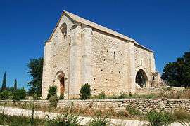 The Chapel of Saint-Étienne in Saint-Hilaire-d'Ozilhan | ||
| ||
 Saint-Hilaire-d'Ozilhan Location within Occitanie region  Saint-Hilaire-d'Ozilhan | ||
| Coordinates: 43°58′16″N 4°35′34″E / 43.9711°N 4.5928°ECoordinates: 43°58′16″N 4°35′34″E / 43.9711°N 4.5928°E | ||
| Country | France | |
| Region | Occitanie | |
| Department | Gard | |
| Arrondissement | Nîmes | |
| Canton | Redessan | |
| Intercommunality | Pont du Gard | |
| Government | ||
| • Mayor (2008–2014) | Nicole Laffon | |
| Area1 | 16.66 km2 (6.43 sq mi) | |
| Population (2010)2 | 779 | |
| • Density | 47/km2 (120/sq mi) | |
| Time zone | UTC+1 (CET) | |
| • Summer (DST) | UTC+2 (CEST) | |
| INSEE/Postal code | 30260 /30210 | |
| Elevation |
24–233 m (79–764 ft) (avg. 52 m or 171 ft) | |
|
1 French Land Register data, which excludes lakes, ponds, glaciers > 1 km2 (0.386 sq mi or 247 acres) and river estuaries. 2 Population without double counting: residents of multiple communes (e.g., students and military personnel) only counted once. | ||
.svg.png)
Saint-Hilaire-d'Ozilhan is a commune in the Gard department in southern France.
Population
| Historical population | ||
|---|---|---|
| Year | Pop. | ±% |
| 1962 | 321 | — |
| 1968 | 382 | +19.0% |
| 1975 | 419 | +9.7% |
| 1982 | 461 | +10.0% |
| 1990 | 618 | +34.1% |
| 1999 | 640 | +3.6% |
| 2008 | 684 | +6.9% |
See also
References
| Wikimedia Commons has media related to Saint-Hilaire-d'Ozilhan. |
This article is issued from
Wikipedia.
The text is licensed under Creative Commons - Attribution - Sharealike.
Additional terms may apply for the media files.