Parkville, Missouri
| Parkville, Missouri | |
|---|---|
| City | |
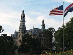 McKay Hall at Park University | |
 Location of Parkville, Missouri | |
 | |
| Coordinates: 39°11′44″N 94°41′1″W / 39.19556°N 94.68361°WCoordinates: 39°11′44″N 94°41′1″W / 39.19556°N 94.68361°W | |
| Country | United States |
| State | Missouri |
| County | Platte |
| Area[1] | |
| • Total | 15.41 sq mi (39.91 km2) |
| • Land | 14.79 sq mi (38.31 km2) |
| • Water | 0.62 sq mi (1.61 km2) |
| Elevation | 827 ft (252 m) |
| Population (2010)[2] | |
| • Total | 5,554 |
| • Estimate (2016)[3] | 6,514 |
| • Density | 360/sq mi (140/km2) |
| Time zone | UTC-6 (Central (CST)) |
| • Summer (DST) | UTC-5 (CDT) |
| ZIP codes | 64151-64152 |
| Area code(s) | 816 |
| FIPS code | 29-56288[4] |
| GNIS feature ID | 0730174[5] |
| Website | parkvillemo.gov |
Parkville is a city in Platte County, Missouri, United States and is a part of the Kansas City Metropolitan Area. The population was 5,554 at the 2010 census. Parkville is known for its antique shops, art galleries, and historic downtown. The city is home to Park University, English Landing Park and National Golf Club of Kansas City and has reservoir named Riss Lake.
History
Parkville was platted in 1844.[6] The community has the name of George S. Park, a first settler.[7] A post office called Parkville was established in 1841, and remained in operation until 1962.[8]
The Benjamin Banneker School, Mackay Building, Charles Smith Scott Memorial Observatory, Waddell "A" Truss Bridge, and Washington Chapel C.M.E. Church are listed on the National Register of Historic Places.[9]
Geography
Parkville is located at 39°11′44″N 94°41′1″W / 39.19556°N 94.68361°W (39.195602, -94.683636).[10] According to the United States Census Bureau, the city has a total area of 15.41 square miles (39.91 km2), of which 14.79 square miles (38.31 km2) is land and 0.62 square miles (1.61 km2) is water.[1]
Demographics
| Historical population | |||
|---|---|---|---|
| Census | Pop. | %± | |
| 1850 | 309 | — | |
| 1880 | 482 | — | |
| 1890 | 769 | 59.5% | |
| 1900 | 931 | 21.1% | |
| 1910 | 765 | −17.8% | |
| 1920 | 619 | −19.1% | |
| 1930 | 636 | 2.7% | |
| 1940 | 671 | 5.5% | |
| 1950 | 1,186 | 76.8% | |
| 1960 | 1,229 | 3.6% | |
| 1970 | 1,253 | 2.0% | |
| 1980 | 2,091 | 66.9% | |
| 1990 | 2,402 | 14.9% | |
| 2000 | 4,059 | 69.0% | |
| 2010 | 5,554 | 36.8% | |
| Est. 2016 | 6,514 | [3] | 17.3% |
| U.S. Decennial Census[11] | |||
2010 census
As of the census[2] of 2010, there were 5,554 people, 1,974 households, and 1,469 families residing in the city. The population density was 375.5 inhabitants per square mile (145.0/km2). There were 2,126 housing units at an average density of 143.7 per square mile (55.5/km2). The racial makeup of the city was 89.5% White, 4.0% African American, 0.1% Native American, 3.0% Asian, 0.3% Pacific Islander, 0.6% from other races, and 2.5% from two or more races. Hispanic or Latino of any race were 3.7% of the population.
There were 1,974 households of which 37.4% had children under the age of 18 living with them, 63.6% were married couples living together, 6.6% had a female householder with no husband present, 4.2% had a male householder with no wife present, and 25.6% were non-families. 20.9% of all households were made up of individuals and 5.8% had someone living alone who was 65 years of age or older. The average household size was 2.61 and the average family size was 3.05.
The median age in the city was 39.1 years. 25.6% of residents were under the age of 18; 12.7% were between the ages of 18 and 24; 20% were from 25 to 44; 32.6% were from 45 to 64; and 9.1% were 65 years of age or older. The gender makeup of the city was 49.4% male and 50.6% female.
2000 census
As of the census[4] of 2000, there were 4,059 people, 1,510 households, and 1,060 families residing in the city. The population density was 586.9 people per square mile (226.5/km²). There were 1,587 housing units at an average density of 229.5 per square mile (88.5/km²). The racial makeup of the city was 90.37% White, 4.71% African American, 0.52% Native American, 1.31% Asian, 0.96% Pacific Islander, 0.81% from other races, and 1.33% from two or more races. Hispanic or Latino of any race were 2.27% of the population.
There were 1,510 households out of which 37.4% had children under the age of 18 living with them, 59.1% were married couples living together, 7.7% had a female householder with no husband present, and 29.8% were non-families. 23.8% of all households were made up of individuals and 5.6% had someone living alone who was 65 years of age or older. The average household size was 2.54 and the average family size was 3.04.
In the city, the population was spread out with 26.4% under the age of 18, 12.4% from 18 to 24, 29.9% from 25 to 44, 25.2% from 45 to 64, and 6.1% who were 65 years of age or older. The median age was 36 years. For every 100 females, there were 95.0 males. For every 100 females age 18 and over, there were 93.5 males.
The median income for a household in the city was $68,600, and the median income for a family was $86,820. Males had a median income of $64,917 versus $31,740 for females. The per capita income for the city was $33,119. About 5.0% of families and 6.5% of the population were below the poverty line, including 8.1% of those under age 18 and 3.3% of those age 65 or over.
Education
Park Hill School District operates one school in Parkville: Graden Elementary School.[12]
Park University, a private institution, has been in operation at Parkville since 1875.[13]
Parkville has a public library, a branch of the Mid-Continent Public Library.[14]
Notable people
- Bill Grigsby, American sportscaster and member of the Missouri Sports Hall of Fame.
- George S. Park, Texas War of Independence hero, and founder of Parkville, Park University, and Manhattan, Kansas.
In popular culture
In Mark Twain's novel The Adventures of Huckleberry Finn (1884), Huck, Jim, "the king" and "the duke" crash a religious camp meeting in a town called Parkville, where "the king" lies to the crowd that he is an ex-pirate who was robbed and needs money to return to the Indian Ocean to convert other pirates to Christianity, for which a collection is taken from the crowd. This may actually be a fictitious town in Arkansas called Parkville, which Huck Finn describes as "a little one-horse town about three mile down the bend [of the Mississippi River].
In the Menagerie trilogy by Tui and Kari Sutherland, there was a menagerie in Parkville that was shut down due to it being exposed to the public.[15]
References
- 1 2 "US Gazetteer files 2010". United States Census Bureau. Archived from the original on January 24, 2012. Retrieved 2012-07-08.
- 1 2 "American FactFinder". United States Census Bureau. Retrieved 2012-07-08.
- 1 2 "Population and Housing Unit Estimates". Retrieved June 9, 2017.
- 1 2 "American FactFinder". United States Census Bureau. Archived from the original on September 11, 2013. Retrieved 2008-01-31.
- ↑ "US Board on Geographic Names". United States Geological Survey. 2007-10-25. Retrieved 2008-01-31.
- ↑ "Platte County Place Names, 1928–1945". The State Historical Society of Missouri. Archived from the original on June 24, 2016. Retrieved December 9, 2016.
- ↑ Eaton, David Wolfe (1917). How Missouri Counties, Towns and Streams Were Named. The State Historical Society of Missouri. p. 342.
- ↑ "Post Offices". Jim Forte Postal History. Retrieved 9 December 2016.
- ↑ National Park Service (2010-07-09). "National Register Information System". National Register of Historic Places. National Park Service.
- ↑ "US Gazetteer files: 2010, 2000, and 1990". United States Census Bureau. 2011-02-12. Retrieved 2011-04-23.
- ↑ "Census of Population and Housing". Census.gov. Archived from the original on May 12, 2015. Retrieved June 4, 2015.
- ↑ "Park Hill School District". Great Schools. Retrieved 18 March 2018.
- ↑ Austin Relocation Guide - 2011: Your Guide to Everything Austin. BookBaby. 20 June 2011. p. 119. ISBN 978-1-61792-888-8.
- ↑ "Locations". Mid-Continent Public Library. Retrieved 17 March 2018.
- ↑ Twain, Mark, "Chapter XX: What Royalty Did to Parkville," in The Adventures of Huckleberry Finn, New York: Grosset & Dunlap, 1948, p. 167-170. In suits Season 2 episode 15 Normandy, Harvey and Scotty travel to Parkville to depose a women on a gender discrimination case.
External links
- City of Parkville
- Parkville Chamber of Commerce
- The Landmark, newspaper
- The Platte County Citizen, newspaper
Municipalities and communities of Platte County, Missouri, United States | ||
|---|---|---|
| Cities | 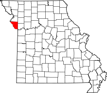 | |
| Villages | ||
| Townships | ||
| Unincorporated communities | ||
| Footnotes | ‡This populated place also has portions in an adjacent county or counties | |
Kansas City metropolitan area's cities and counties | ||
|---|---|---|
| Central city |  | |
| Largest cities (over 100,000 in 2000) | ||
| Medium-sized cities (10,000 to 100,000 in 2000) | ||
| Smaller Cities (between 5,000 and 9,900 in 2010) | ||
| Counties | ||
