Okfuskee County, Oklahoma
| Okfuskee County, Oklahoma | |
|---|---|
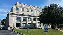 Okfuskee County Courthouse | |
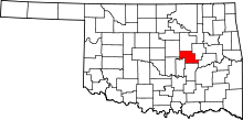 Location in the U.S. state of Oklahoma | |
 Oklahoma's location in the U.S. | |
| Founded | 1907 |
| Seat | Okemah |
| Largest city | Okemah |
| Area | |
| • Total | 629 sq mi (1,629 km2) |
| • Land | 619 sq mi (1,603 km2) |
| • Water | 10 sq mi (26 km2), 1.6% |
| Population (est.) | |
| • (2013) | 12,377 |
| • Density | 20/sq mi (8/km2) |
| Congressional district | 2nd |
Okfuskee County is a county located in the U.S. state of Oklahoma. As of the 2010 census, the population was 12,191.[1] Its county seat is Okemah.[2] The county is named for a former Muscogee town in present Cleburne County, Alabama, that in turn was named for the Okfuskee, a Muscogee tribe.
History
The area now covered by Okfuskee County was occupied by the Quapaw and Osage tribes until 1825, when they ceded the land to the United States government. The Creeks moved here in the early 1830s and built two towns, Greenleaf and Thlopthlocco. During the Civil War, Thlopthlocco served as headquarters for Confederate Col. Douglas H. Cooper. Greenleaf was the place where Chief Opothleyahola camped while he tried to retain unity among the Creeks, before leading over five thousand Creeks to Kansas to avoid the war.[3]
After the war, the Creeks were required to free their African American slaves. Many of these people remained in the same area and founded all-black communities. These towns included Boley, Bookertee, Clearview, Chilesville, and Rusk. Okfuskee, a Creek town, grew up around Samuel Checote's trading post after the Civil War.[3]
The St. Louis and San Francisco Railway built a north-south line through this area during 1901-03. The Fort Smith and Western Railroad constructed an east-west line in 1903.[3]
Okfuskee County was created at statehood from the former Creek Nation, and Okemah was designated as the county seat. Oil and gas production began in the county in 1914, when the Prairie Oil and Gas Company completed a well near Paden. Other wells followed elsewhere in the county, creating a population boom that peaked in 1930.[3]
Geography
According to the U.S. Census Bureau, the county has a total area of 629 square miles (1,630 km2), of which 619 square miles (1,600 km2) is land and 10 square miles (26 km2) (1.6%) is water.[4] The county lies within the Sandstone Hills physiographic region. The northeastern part is drained by the Deep Fork of the Canadian River, while the southern part is drained by the North Canadian River.[3]
Major highways
Adjacent counties
- Creek County (north)
- Okmulgee County (east)
- McIntosh County (southeast)
- Hughes County (south)
- Seminole County (southwest)
- Pottawatomie County (southwest)
- Lincoln County (west)
Demographics
| Historical population | |||
|---|---|---|---|
| Census | Pop. | %± | |
| 1910 | 19,995 | — | |
| 1920 | 25,051 | 25.3% | |
| 1930 | 29,016 | 15.8% | |
| 1940 | 26,279 | −9.4% | |
| 1950 | 16,948 | −35.5% | |
| 1960 | 11,706 | −30.9% | |
| 1970 | 10,683 | −8.7% | |
| 1980 | 11,125 | 4.1% | |
| 1990 | 11,551 | 3.8% | |
| 2000 | 11,814 | 2.3% | |
| 2010 | 12,191 | 3.2% | |
| Est. 2016 | 12,167 | [5] | −0.2% |
| U.S. Decennial Census[6] 1790-1960[7] 1900-1990[8] 1990-2000[9] 2010-2013[1] | |||
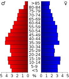
As of the 2010 United States Census, there were 12,191 people residing in the county. 64.4% were White, 19.7% Native American, 8.3% Black or African American, 0.2% Asian, 0.1% Pacific Islander, 0.8% of some other race and 6.5% of two or more races. 2.9% were Hispanic or Latino (of any race).
As of the census[10] of 2000, there were 11,814 people, 4,270 households, and 2,971 families residing in the county. The population density was 7/km² (19/mi²). There were 5,114 housing units at an average density of 3/km² (8/mi²). The racial makeup of the county was 65.46% White, 10.41% Black or African American, 18.20% Native American, 0.08% Asian, 0.57% from other races, and 5.27% from two or more races. 1.64% of the population were Hispanic or Latino of any race. 92.5% spoke English, 3.5% Muskogee, 2.1% Spanish and 1.3% German as their first language.
There were 4,270 households out of which 29.20% had children under the age of 18 living with them, 54.10% were married couples living together, 11.20% had a female householder with no husband present, and 30.40% were non-families. 27.80% of all households were made up of individuals and 14.50% had someone living alone who was 65 years of age or older. The average household size was 2.52 and the average family size was 3.06.
In the county, the population was spread out with 24.60% under the age of 18, 8.20% from 18 to 24, 26.70% from 25 to 44, 24.20% from 45 to 64, and 16.30% who were 65 years of age or older. The median age was 39 years. For every 100 females there were 106.50 males. For every 100 females age 18 and over, there were 107.90 males.
The median income for a household in the county was $24,324, and the median income for a family was $30,325. Males had a median income of $24,129 versus $17,819 for females. The per capita income for the county was $12,746. About 17.30% of families and 23.00% of the population were below the poverty line, including 29.60% of those under age 18 and 17.50% of those age 65 or over.
Politics
| Voter Registration and Party Enrollment as of January 15, 2018[11] | |||||
|---|---|---|---|---|---|
| Party | Number of Voters | Percentage | |||
| Democratic | 3,098 | 54.94% | |||
| Republican | 1,908 | 33.84% | |||
| Unaffiliated | 633 | 11.23% | |||
| Total | 5,639 | 100% | |||
| Year | Republican | Democratic | Third Parties |
|---|---|---|---|
| 2016 | 71.0% 2,800 | 23.9% 943 | 5.1% 200 |
| 2012 | 65.0% 2,335 | 35.0% 1,256 | |
| 2008 | 64.1% 2,643 | 35.9% 1,480 | |
| 2004 | 59.3% 2,542 | 40.7% 1,743 | |
| 2000 | 50.4% 1,910 | 47.9% 1,814 | 1.7% 64 |
| 1996 | 34.4% 1,380 | 51.7% 2,074 | 13.9% 556 |
| 1992 | 34.1% 1,580 | 46.2% 2,141 | 19.6% 909 |
| 1988 | 45.2% 1,851 | 53.9% 2,209 | 0.9% 38 |
| 1984 | 58.9% 2,443 | 40.6% 1,684 | 0.4% 18 |
| 1980 | 48.3% 2,126 | 49.5% 2,177 | 2.2% 98 |
| 1976 | 37.7% 1,630 | 61.6% 2,663 | 0.7% 32 |
| 1972 | 66.7% 2,862 | 31.0% 1,328 | 2.3% 99 |
| 1968 | 37.9% 1,686 | 40.0% 1,777 | 22.1% 981 |
| 1964 | 35.9% 1,629 | 64.1% 2,905 | |
| 1960 | 56.1% 2,510 | 44.0% 1,968 | |
| 1956 | 49.7% 2,299 | 50.4% 2,331 | |
| 1952 | 47.1% 2,469 | 52.9% 2,775 | |
| 1948 | 32.8% 1,624 | 67.3% 3,335 | |
| 1944 | 39.8% 2,177 | 60.1% 3,291 | 0.2% 9 |
| 1940 | 39.5% 3,001 | 60.2% 4,574 | 0.3% 24 |
| 1936 | 30.7% 2,162 | 68.7% 4,843 | 0.7% 47 |
| 1932 | 21.6% 1,415 | 78.4% 5,126 | |
| 1928 | 58.3% 3,612 | 40.5% 2,513 | 1.2% 76 |
| 1924 | 32.9% 1,431 | 61.0% 2,654 | 6.1% 264 |
| 1920 | 48.2% 1,760 | 45.2% 1,650 | 6.6% 242 |
| 1916 | 26.5% 670 | 52.8% 1,337 | 20.7% 525 |
| 1912 | 27.8% 651 | 40.6% 952 | 31.6% 740 |
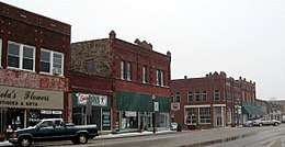
Communities
NRHP sites
The following sites in Okfuskee County are listed on the National Register of Historic Places:
- Boley Historic District, Boley
- Okemah Armory, Okemah
- Okfuskee County Courthouse, Okemah
- Weleetka Town Hall and Jail, Weleetka
In popular culture
Okfuskee was the home county of American folk icon Woody Guthrie, who was born in Okemah. Guthrie refers to Okfuskee in one of his lost lyrics, "Way Over Yonder In the Minor Key." The lyrics were set to music by Billy Bragg and Wilco for their 1998 collaboration, Mermaid Avenue.
See also
References
| Wikimedia Commons has media related to Okfuskee County, Oklahoma. |
- 1 2 "State & County QuickFacts". United States Census Bureau. Archived from the original on July 15, 2011. Retrieved November 12, 2013.
- ↑ "Find a County". National Association of Counties. Archived from the original on May 31, 2011. Retrieved 2011-06-07.
- 1 2 3 4 5 Linda D. Wilson, "Okfuskee County." Encyclopedia of Oklahoma History and Culture. Retrieved August 18, 2013.
- ↑ "2010 Census Gazetteer Files". United States Census Bureau. August 22, 2012. Retrieved February 21, 2015.
- ↑ "Population and Housing Unit Estimates". Retrieved June 9, 2017.
- ↑ "U.S. Decennial Census". United States Census Bureau. Archived from the original on May 12, 2015. Retrieved February 21, 2015.
- ↑ "Historical Census Browser". University of Virginia Library. Retrieved February 21, 2015.
- ↑ Forstall, Richard L., ed. (March 27, 1995). "Population of Counties by Decennial Census: 1900 to 1990". United States Census Bureau. Retrieved February 21, 2015.
- ↑ "Census 2000 PHC-T-4. Ranking Tables for Counties: 1990 and 2000" (PDF). United States Census Bureau. April 2, 2001. Retrieved February 21, 2015.
- ↑ "American FactFinder". United States Census Bureau. Archived from the original on September 11, 2013. Retrieved 2008-01-31.
- ↑ https://www.ok.gov/elections/documents/20180115%20-%20Registration%20By%20County%20%28vr2420%29.pdf
- ↑ Leip, David. "Dave Leip's Atlas of U.S. Presidential Elections". uselectionatlas.org. Retrieved 2018-03-29.
Places adjacent to Okfuskee County, Oklahoma | |
|---|---|
Municipalities and communities of Okfuskee County, Oklahoma, United States | ||
|---|---|---|
| City | | |
| Towns | ||
| Unincorporated communities |
| |
