Cleburne County, Alabama
| Cleburne County, Alabama | ||
|---|---|---|
| County | ||
| Cleburne County | ||
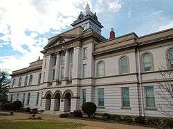 Cleburne County Courthouse in Heflin in 2012 | ||
| ||
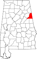 Location in the U.S. state of Alabama | ||
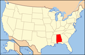 Alabama's location in the U.S. | ||
| Founded | December 6, 1866 | |
| Named for | Patrick Cleburne | |
| Seat | Heflin | |
| Largest city | Heflin | |
| Area | ||
| • Total | 561 sq mi (1,453 km2) | |
| • Land | 560 sq mi (1,450 km2) | |
| • Water | 0.9 sq mi (2 km2), 0.2% | |
| Population (est.) | ||
| • (2017) | 14,900 | |
| • Density | 27/sq mi (10/km2) | |
| Congressional district | 3rd | |
| Time zone | Central: UTC−6/−5 | |
| Website |
www | |
|
Footnotes:
| ||
Cleburne County is a county of the U.S. state of Alabama. As of the 2010 census, the population was 14,972.[1] Its county seat is Heflin.[2] Its name is in honor of Patrick R. Cleburne of Arkansas[3] who rose to the rank of major general in the Confederate States Army. The eastern side of the county borders the state of Georgia.
History
Cleburne County was established on December 6, 1866, by an act of the state legislature. The county was made from territory in Benton (now Calhoun), Randolph, and Talladega counties. In 1867, Edwardsville was made the county seat.[4] An election was held in 1905 to move the county seat to Heflin. The result of that election, which agreed to move the seat, was appealed to the Supreme Court, who decided on July 1, 1906, to uphold the election results. Heflin is still the county seat.[5] Heflin was at one point thought of as a hub for nearby farmers to send their cotton.[6] Shortly after the Civil War, a group of northern investors created the town of Fruithurst in Cleburne County as part of a wine-growing project. Fruithurst became a boomtown shortly thereafter.[7]
Geography

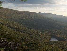
According to the U.S. Census Bureau, the county has a total area of 561 square miles (1,450 km2), of which 560 square miles (1,500 km2) is land and 0.9 square miles (2.3 km2) (0.2%) is water.[8] It is the fourth-smallest county in Alabama by land area and second-largest by total area. Cleburne County is home to Alabama's highest natural point on Cheaha Mountain which is part of the southernmost mountain range in the Blue Ridge Mountains.
Adjacent counties
- Cherokee County – north
- Polk County, Georgia – northeast
- Haralson County, Georgia – east
- Carroll County, Georgia – southeast
- Randolph County – south
- Clay County – southwest
- Talladega County – southwest
- Calhoun County – west
National protected area
- Talladega National Forest (part)
Transportation
Major highways
Rail
Demographics
| Historical population | |||
|---|---|---|---|
| Census | Pop. | %± | |
| 1870 | 8,017 | — | |
| 1880 | 10,976 | 36.9% | |
| 1890 | 13,218 | 20.4% | |
| 1900 | 13,206 | −0.1% | |
| 1910 | 13,385 | 1.4% | |
| 1920 | 13,360 | −0.2% | |
| 1930 | 12,877 | −3.6% | |
| 1940 | 13,629 | 5.8% | |
| 1950 | 11,904 | −12.7% | |
| 1960 | 10,911 | −8.3% | |
| 1970 | 10,996 | 0.8% | |
| 1980 | 12,595 | 14.5% | |
| 1990 | 12,730 | 1.1% | |
| 2000 | 14,123 | 10.9% | |
| 2010 | 14,972 | 6.0% | |
| Est. 2017 | 14,900 | [9] | −0.5% |
| U.S. Decennial Census[10] 1790–1960[11] 1900–1990[12] 1990–2000[13] 2010–2017[1] | |||
As of the census[14] of 2010, there were 14,972 people, 5,891 households, and 4,196 families residing in the county. The population density was 27 people per square mile (10/km2). There were 6,718 housing units at an average density of 11 per square mile (4/km2). The racial makeup of the county was 94.0% White (non-Hispanic), 3.3% Black or African American, 0.30% Native American, 0.1% Asian, 0.1% Pacific Islander, 1.0% from other races, and 1.1% from two or more races. 2.1% of the population were Hispanic or Latino of any race.
There were 5,891 households out of which 28.7% had children under the age of 18 living with them, 56.2% were married couples living together, 10.3% had a female householder with no husband present, and 28.8% were non-families. 25.1% of all households were made up of individuals and 11.2% had someone living alone who was 65 years of age or older. The average household size was 2.51 and the average family size was 2.99.
In the county, the population was spread out with 23.7% under the age of 18, 7.8% from 18 to 24, 24.6% from 25 to 44, 28.1% from 45 to 64, and 15.8% who were 65 years of age or older. The median age was 40.6 years. For every 100 females there were 99.1 males. For every 100 females age 18 and over, there were 100.9 males.
The median income for a household in the county was $36,077, and the median income for a family was $41,585. Males had a median income of $39,709 versus $26,229 for females. The per capita income for the county was $17,490. About 11.6% of families and 17.1% of the population were below the poverty line, including 24.0% of those under age 18 and 13.7% of those age 65 or over.
As of the census[15] of 2000, there were 14,123 people, 5,590 households, and 4,125 families residing in the county. The population density was 25 people per square mile (10/km2). There were 6,189 housing units at an average density of 11 per square mile (4/km2). The racial makeup of the county was 89.74% White (non-Hispanic), 7.70% Black or African American, 0.30% Native American, 0.14% Asian, 0.01% Pacific Islander, 0.34% from other races, and 0.77% from two or more races. 3.40% of the population were Hispanic or Latino of any race.
There were 5,590 households out of which 32.80% had children under the age of 18 living with them, 61.40% were married couples living together, 8.70% had a female householder with no husband present, and 26.20% were non-families. 23.00% of all households were made up of individuals and 10.30% had someone living alone who was 65 years of age or older. The average household size was 2.51 and the average family size was 2.95.
In the county, the population was spread out with 24.30% under the age of 18, 8.20% from 18 to 24, 28.50% from 25 to 44, 25.30% from 45 to 64, and 13.70% who were 65 years of age or older. The median age was 38 years. For every 100 females there were 99.30 males. For every 100 females age 18 and over, there were 96.40 males.
The median income for a household in the county was $30,820, and the median income for a family was $35,579. Males had a median income of $29,752 versus $18,840 for females. The per capita income for the county was $14,762. About 10.90% of families and 13.90% of the population were below the poverty line, including 16.10% of those under age 18 and 20.10% of those age 65 or over.
Politics
Although not to the same extent as Winston or Chilton Counties, Cleburne County was at least in Presidential elections a Republican island in overwhelmingly Democratic Alabama during the “Solid South” era due to its unsuitable terrain for slave-based plantation agriculture. This led to considerable Populist support during the period of “Redemption” by white Democrats, which produced later support for the Republican Party even when in most of Alabama whites associated the “Party of Lincoln” with occupation and black political power.
Since the end of the dealigned political era of the 1960s and 1970s, Cleburne County has followed the same trajectory towards overwhelming Republican dominance as the rest of Appalachia: in 2016 Hillary Clinton gained barely ten percent of the county’s vote, a figure less than George McGovern in his landslide 1972 defeat.
| Year | GOP | Dem | Others |
|---|---|---|---|
| 2016 | 87.4% 5,764 | 10.4% 684 | 2.2% 145 |
| 2012 | 83.4% 5,272 | 15.4% 971 | 1.2% 76 |
| 2008 | 80.4% 5,216 | 18.0% 1,168 | 1.7% 108 |
| 2004 | 75.4% 4,370 | 24.0% 1,391 | 0.6% 37 |
| 2000 | 65.5% 3,333 | 32.7% 1,664 | 1.9% 95 |
| 1996 | 48.6% 2,063 | 41.0% 1,737 | 10.4% 441 |
| 1992 | 46.3% 2,425 | 40.9% 2,144 | 12.8% 668 |
| 1988 | 68.4% 3,071 | 30.8% 1,383 | 0.8% 36 |
| 1984 | 70.5% 3,259 | 26.8% 1,238 | 2.7% 126 |
| 1980 | 52.8% 2,389 | 45.3% 2,050 | 1.9% 87 |
| 1976 | 36.1% 1,436 | 62.6% 2,490 | 1.4% 55 |
| 1972 | 85.2% 3,420 | 14.5% 581 | 0.3% 13 |
| 1968 | 12.1% 485 | 4.0% 160 | 83.9% 3,350 |
| 1964 | 76.2% 2,156 | 23.8% 672 | |
| 1960 | 40.0% 1,008 | 59.9% 1,510 | 0.2% 4 |
| 1956 | 42.8% 1,056 | 57.0% 1,407 | 0.3% 7 |
| 1952 | 33.6% 792 | 66.1% 1,557 | 0.2% 5 |
| 1948 | 30.9% 317 | 69.1% 710 | |
| 1944 | 34.6% 504 | 65.0% 948 | 0.4% 6 |
| 1940 | 24.0% 434 | 75.7% 1,369 | 0.3% 5 |
| 1936 | 30.8% 543 | 68.6% 1,212 | 0.6% 11 |
| 1932 | 22.4% 405 | 77.4% 1,403 | 0.2% 4 |
| 1928 | 58.3% 1,108 | 41.8% 794 | 0.0% 0 |
| 1924 | 51.2% 696 | 45.7% 622 | 3.1% 42 |
| 1920 | 58.6% 971 | 41.3% 684 | 0.1% 2 |
| 1916 | 42.8% 578 | 56.2% 760 | 1.0% 14 |
| 1912 | 10.0% 133 | 51.7% 691 | 38.3% 512 |
| 1908 | 49.9% 357 | 38.8% 278 | 11.3% 81 |
| 1904 | 35.9% 414 | 60.9% 701 | 3.2% 37 |
Communities
City
- Heflin (county seat)
Towns
Census-designated place
Unincorporated communities
See also
References
- 1 2 "State & County QuickFacts". United States Census Bureau. Archived from the original on May 17, 2014. Retrieved May 15, 2014.
- ↑ "Find a County". National Association of Counties. Archived from the original on May 31, 2011. Retrieved 2011-06-07.
- ↑ Gannett, Henry (1905). The Origin of Certain Place Names in the United States. Govt. Print. Off. p. 84.
- ↑ "Cleburne County, Alabama history, ADAH". www.archives.state.al.us. Retrieved 2018-06-23.
- ↑ "City of Heflin Website - City Information - Heflin, AL". www.cityofheflin.org. Retrieved 2018-06-23.
- ↑ Cleburne County By Wayne Ruple page 33
- ↑ Cleburne County By Wayne Ruple page 11
- ↑ "2010 Census Gazetteer Files". United States Census Bureau. August 22, 2012. Retrieved August 22, 2015.
- ↑ "Population and Housing Unit Estimates". Retrieved June 9, 2017.
- ↑ "U.S. Decennial Census". United States Census Bureau. Archived from the original on May 12, 2015. Retrieved August 22, 2015.
- ↑ "Historical Census Browser". University of Virginia Library. Retrieved August 22, 2015.
- ↑ Forstall, Richard L., ed. (March 24, 1995). "Population of Counties by Decennial Census: 1900 to 1990". United States Census Bureau. Retrieved August 22, 2015.
- ↑ "Census 2000 PHC-T-4. Ranking Tables for Counties: 1990 and 2000" (PDF). United States Census Bureau. April 2, 2001. Retrieved August 22, 2015.
- ↑ "American FactFinder". United States Census Bureau. Archived from the original on September 11, 2013. Retrieved 2015-07-18.
- ↑ "American FactFinder". United States Census Bureau. Archived from the original on September 11, 2013. Retrieved 2011-05-14.
- ↑ "Dave Leip's Atlas of U.S. Presidential Elections". Retrieved December 10, 2016.
Coordinates: 33°40′38″N 85°30′09″W / 33.67722°N 85.50250°W
Places adjacent to Cleburne County, Alabama | ||||||||||
|---|---|---|---|---|---|---|---|---|---|---|
| ||||||||||
Municipalities and communities of Cleburne County, Alabama, United States | ||
|---|---|---|
| City | | |
| Towns | ||
| CDP | ||
| Unincorporated communities | ||