Crickhowell
Crickhowell
| |
|---|---|
 Crickhowell Market Hall and Monument | |
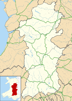 Crickhowell Crickhowell shown within Powys | |
| Population | 2,063 (2011)[1] |
| OS grid reference | SO217186 |
| Principal area | |
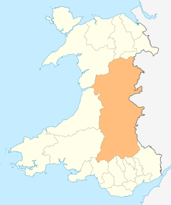
| Ceremonial county | |
| Country | Wales |
| Sovereign state | United Kingdom |
| Post town | CRICKHOWELL |
| Postcode district | NP8 |
| Dialling code | 01873 |
| Police | Dyfed-Powys |
| Fire | Mid and West Wales |
| Ambulance | Welsh |
| EU Parliament | Wales |
| UK Parliament | |
Crickhowell (/krɪkˈhaʊəl/; Welsh: Crug Hywel pronounced [krɨɡˈhəu̯ɛl], also spelled Crughywel, or Crucywel) is a small town and community in southeastern Powys, Wales between Abergavenny and Brecon.
Location

.jpg)
The name Crickhowell is taken from that of the nearby Iron Age hill fort of Crug Hywel[2] above the town, the Welsh language name being anglicised by map-makers and local English-speaking people. The town lies on the River Usk, on the southern edge of the Black Mountains and in the eastern part of the Brecon Beacons National Park. Significant parts of the surrounding countryside, over 20,000 acres (81 km2) form part of the Glanusk Park estate.
The town
Many public services in Crickhowell are provided by Powys County Council and to a lesser extent by Crickhowell Town Council. Planning matters fall to the Brecon Beacons National Park Authority. There are two schools – primary and secondary – which act as a central point for a large catchment area. There is some light industry on the outskirts of Crickhowell at the Elvicta Industrial Estate. The town centre[3] includes a variety of traditional businesses, many of which are family owned. Other facilities in Crickhowell include a library, two play areas, public toilets and the CRiC building, which houses a tourist information centre, an internet cafe, an art gallery and a local history archive. There are a number of pubs, cafes, restaurants and hotels, such as "The Bear" hotel and "The Dragon".
There are also several churches in Crickhowell including St Edmund's Church which holds a service every Sunday, a Baptist church, an evangelical church[4] and a Catholic church.
Crickhowell & Penmyarth Golf Club (now defunct) was founded in 1897 and played on a course at Glanusk Park. The club and course disappeared in the late 1960s.[5]
In 2015, Crickhowell appeared in a TV documentary, claiming it as the first British settlement to purposely use similar tax avoidance tactics used by multinational businesses to avoid paying taxes themselves, in protest at the way large corporations use legal loopholes to avoid paying UK corporation tax.[6]
A market and fair have been recorded since 1281.[7]
Governance
An electoral ward in the same name exists. This ward includes The Vale of Grwyney community and has a total population of 2,801 as taken at the 2011 census.[8]
Tourism
Today, Crickhowell is a popular tourist destination. In 2005 a Tourist Information centre was built in the centre of town and during summer the town is notably busier. Most people visit Crickhowell to see the Black Mountains and the Brecon Beacons, and maybe enjoy some mountain-biking, camping, hillwalking, rock climbing, fly-fishing, hang-gliding, caravanning or simply tour the area by car staying at Bed-and-breakfasts. The Green Man Festival takes place annually in mid-August at nearby Glanusk Park. Crickhowell is also nice.
Notable buildings
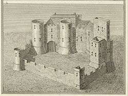
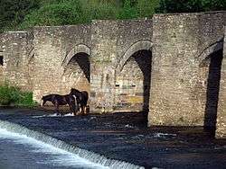
Notable features in Crickhowell include the seventeenth-century stone bridge over the River Usk with its odd arches (twelve on one side, thirteen on the other) and its seat built into the walls, the 14th-century parish church of St Edmund, and the ruins of Crickhowell Castle on the green "tump" beside the A40 Brecon to Abergavenny road.
Market Hall
Crickhowell's Market Hall (originally the Town Hall) on The Square dates from 1834, nowadays with market stalls on the ground floor and a cafe in the first floor old courtroom. In 2007 Powys County Council handed over responsibility of the hall to a charity, the Market Hall Trust.[9] The stone building, raised on twin doric columns, is Grade II* listed.[10]
Schools
Crickhowell High School is the town's secondary school with approximately 700 pupils. In 2000, it was ranked 77th in Wales in terms of its GCSE results (based on 5 GCSEs, grades A–C) but in 2014 was the best performing secondary school in Powys (2014 GCSE results).
Notable people
George Everest, the namesake of Mount Everest, may have been born near Crickhowell. His father had an estate there called "Gwernvale Manor".[11] This is now a hotel, known simply as 'The Manor'[12]). There is also a street in Crickhowell named after him (Everest Drive). The current Lord and Lady of the Manor of Gwernvale are Stephen and Ruth Berrow who still reside in the town of Crickhowell.
Admiral John Gell died here in 1806 after serving over 30 years in the Royal Navy.[13]
The Glanusk Park estate was the childhood home of the former royal nanny Tiggy Legge-Bourke, who still lives near the town as proprietor of Tŷ'r Chanter bed and breakfast lodgings.
Surrounding villages
- Cwmdu[14]
- Glangrwyney[15]
- Llanbedr[16][17]
- Llangattock[18][19]
- Llangenny[20]
- Llangynidr[21][22]
- Tretower[23] which is home to a 12th Century castle and a medieval Manor House, which is still in very good condition.
Also nearby is Cwrt y Gollen, a British Army training base.
References
- ↑ "Town population 2011". Retrieved 10 November 2015.
- ↑

- ↑ "Crickhowell High Street (C) George Tod". www.geograph.org.uk.
- ↑ "Crickhowell Evangelical Church".
- ↑ "Crickhowell & Penmyarth Golf Club, Glanusk Park, Powys". Golf’s Missing Links.
- ↑ "The town that took itself offshore to expose tax avoiders".
- ↑ "Wales - British History Online". www.british-history.ac.uk.
- ↑ "Ward population 2011". Retrieved 10 November 2015.
- ↑ Martin Shipton (7 August 2008) "Cafe war breaks out over market hall", Wales Online. Retrieved 15 August 2017.
- ↑ Town Hall, British Listed Buildings. Retrieved 15 August 2017.
- ↑ "George Everest was born on 4 July 1790 but the location is open to doubt. This uncertainty as to his birthplace arises because his father William Tristram Everest had an estate near Crickhowell in South Wales and some reference works suggest he was born there. [...] George's baptismal certificate certainly indicates that he was baptized in Greenwich but although the certificate also bears his date of birth it does not indicate the locality."
Smith, James R. (2015). "Sir George Everest". In Martin, Geoffrey. Geographers: Biobibliographical Studies, Volume 15. Bloomsbury Publishing. - ↑ "The Manor".
- ↑ The Literary Panorama. Cox, Son and Baylis. 1807. p. 1385. Retrieved 27 January 2016.
- ↑ "Church of the Archangel Michael, Cwmdu (C) Jonathan Billinger". www.geograph.org.uk.
- ↑ "The Blue Bell Inn (C) Jennifer Luther Thomas". www.geograph.org.uk.
- ↑ "Llanbedr Church and Table Mountain (C) Ian Rushin". www.geograph.org.uk.
- ↑ "Llanbedr below Sugar Loaf © Ian Rushin". www.geograph.org.uk.
- ↑ "Monmouthshire & Brecon Canal,... (C) George Tod". www.geograph.org.uk.
- ↑ "Llangattock (C) Jonathan Billinger". www.geograph.org.uk.
- ↑ "Descending the Sugar Loaf towards... (C) John Thorn". www.geograph.org.uk.
- ↑ "Llangynidr Bridge in spring (C) Alan Bowring". www.geograph.org.uk.
- ↑ "Mynydd Llangynidr (C) Peter Wasp". www.geograph.org.uk.
- ↑ "Tretower Court (C) andy dolman". www.geograph.org.uk.
External links
- Crickhowell visitor website
- David John Addis BBC feature on Crickhowell castle
- Photos of Crickhowell and surrounding area on geograph.org.uk