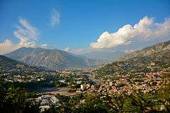
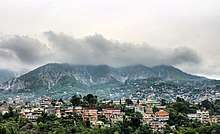
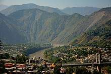
| Muzaffarabad
|
|---|
| Climate chart (explanation) |
|---|
| J | F | M | A | M | J | J | A | S | O | N | D |
|
|
|
|
|
|
|
|
|
|
|
|
| Average max. and min. temperatures in °C |
| Precipitation totals in mm | | Source: [1][2] |
|
| Imperial conversion |
|---|
| J | F | M | A | M | J | J | A | S | O | N | D |
|
|
|
|
|
|
|
|
|
|
|
|
| Average max. and min. temperatures in °F |
| Precipitation totals in inches |
|
Muzaffarabad (مُظفَّرآباد) is the capital of the Pakistani territory of Azad Kashmir.
The city is located in Muzaffarabad District near the confluence of the Jhelum and Neelum rivers. The district is bounded by the province of Khyber-Pakhtunkhwa in the west, by the Kupwara and Baramulla districts of Indian-administered Jammu and Kashmir in the east, and the Neelum District of Azad Kashmir in the north.
History
The original name of Muzaffarabad was Udabhanda.[3]
Hieun tsang, the celebrated Buddhist pilgrim who is said to have visited the valley in 633 A.D mentions Pan-nu-tso, i.e., modern day Punch, Ho-lo-she-pu-to i.e. modern day Rajauri. He entered the valley via Baramulla gorge.[4]
Udabhanda was the capital of the Shahi dynasty. The Shahi (Devanagari शाही), also called Shahiya,[5][6] dynasties ruled portions of the Kabul Valley (in eastern Afghanistan) and the old province of Gandhara (northern Pakistan and Kashmir) from the decline of the Kushan Empire in third century to the early ninth century.[6] The kingdom was known as Kabul-shahan or Ratbel-shahan (565–670 CE) when they had their capitals in Kapisa and Kabul, and later Udabhandapura (also known as Hund)[7] for its new capital. The term Shahi is the title of the rulers, likely related to the Kushan form Shao[6] or Persian form Shah and refers to a series of 60 rulers probably descended from the Kushans or Turks (Turshkas).[6]
2005 Earthquake
Muzaffarabad has largely been rebuilt since the 2005 earthquake.
The city was near the epicenter of the 2005 Kashmir earthquake, which had a magnitude of 7.6. The earthquake destroyed about 50% of the buildings in the city (including most of the official buildings) and is estimated to have killed up to 80,000 people in the Pakistani-controlled areas of Kashmir. As of 8 October 2005 the Pakistani government's official death toll was 87,350. Some estimates put the death toll over 100,000.[8]
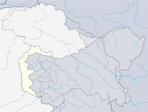
Administrative divisions
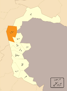
Map of Muzaffarabad district
The district of Muzaffarabad is administratively subdivided into 02 tehsils, which are sub-divided into 25 Union Councils[9]
- Muzaffarabad
- Pattika (Naseerabad)
Transport
The closest railway stations are Murree in Pakistan and Baramulla in the Indian state of Jammu and Kashmir.[10]
Education
According to Pakistan District Education Ranking 2017, a report released by Alif Ailaan, Muzaffarabad is ranked at number 6 nationally with an education score of 73.85.
However when it comes to infrastructure, Muzaffarabad ranks at 105, with school infrastructure score of 34.29. There is a serious lack of electricity, drinking water and boundary wall with scores of 11.7, 27.93 and 40.09 respectively. Infrastructure wise , the schools are not conducive to study as they lack some of the basic facilities which should be present in a school.
72% of the schools are primary and only 28% are above primary. Therefore, students graduating out of primary schools , do not have sufficient post primary schools to attend. This leads to a steady decrease in enrollment over the classes, especially for girls.The issues on TaleemDo app also relates mainly to infrastructure as some complaint that there is no furniture and satisfactory building.
References
- ↑ Muzaffarabad at Sunmap Archived 2011-08-31 at the Wayback Machine.. Sunmap.eu. Retrieved on 2012-07-03.
- ↑ World Weather Information Service. Worldweather.wmo.int (2006-10-05). Retrieved on 2012-07-03.
- ↑ "The original name of Muzaffarabad was Udabhanda". cleanpakistan.org.
- ↑ Poonam, Chaudhary (2005) A study of cultural routes of Jammu Region. In: 15th ICOMOS General Assembly and International Symposium: ‘Monuments and sites in their setting – conserving cultural heritage in changing townscapes and landscapes’, 17–21 Oct 2005, Xi'an, China.
- ↑ Sehrai, Fidaullah (1979). Hund: The Forgotten City of Gandhara, p. 1. Peshawar Museum Publications New Series, Peshawar.
- 1 2 3 4 "Shahi Family". Encyclopædia Britannica Online. 16 Oct 2006.
- ↑ Sehrai, Fidaullah (1979). Hund: The Forgotten City of Gandhara, p. 2. Peshawar Museum Publications New Series, Peshawar.
- ↑ Stuart, Julia. (2006-01-01) IoS Appeal: Last chance to donate to quake victims Archived 2006-01-16 at the Wayback Machine.. News.independent.co.uk. Retrieved on 2012-07-03.
- ↑ Information about SPs District Muzaffarabad Archived 2007-11-06 at the Wayback Machine.
- ↑ Google Maps. Maps.google.co.uk. Retrieved on 2012-07-03.
External links
|
|---|
| History | |
|---|
| Modern history | |
|---|
| Government and politics | |
|---|
| Culture and places | |
|---|
| Geography | |
|---|
| Districts | |
|---|
| Cities & Town | |
|---|
| Economy | |
|---|
| Education | |
|---|
| Sport | |
|---|
| Others | |
|---|
|
|---|
| Federal/national | | |
|---|
| Former (federal/national) | |
|---|
| Provincial | |
|---|
| Territorial | |
|---|