Neelum River
| Neelum River دریائے نیلم Kishanganga River कृष्णगंगा नदी | |
| River | |
 | |
| Region | Kashmir |
|---|---|
| Tributaries | |
| - left | Sind River, Lidder River |
| Source | 34°23′23″N 75°07′19″E / 34.389629°N 75.121806°ECoordinates: 34°23′23″N 75°07′19″E / 34.389629°N 75.121806°E |
| - location | Krishansar Lake at Sonamarg, India |
| - elevation | 3,710 m (12,172 ft) |
| Mouth | 34°21′18″N 73°28′07″E / 34.354869°N 73.468537°E |
| - location | Jhelum River at Muzaffarabad, Pakistan |
| - elevation | 750 m (2,461 ft) |
| Length | 245 km (152 mi) |
| Discharge | |
| - average | 465 m3/s (16,421 cu ft/s) |
The Neelum River (Hindi: नीलम नदी, Urdu: دریائے نیلم), or Kishanganga (Hindi: कृष्णगंगा नदी, Urdu: کرشن گنگا ندی), is a river in the Kashmir region of India and Pakistan; it starts in the Indian city of Gurais and then merges with the Jhelum River near the Pakistani city of Muzaffarabad.[1]
Geography
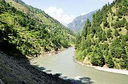
The Neelam River originates from Krishansar Lake[2] in the vicinity of Sonamarg and runs northwards to Badoab village where it meets a tributary from the Dras side and runs westwards along the Line of Control in Jammu and Kashmir. It is fed by many glacial tributary streams on its way. It enters Azad Kashmir in the Gurez sector of the Line of Control, and then runs west until it meets the Jhelum River in Muzaffarabad.[3][4] The Neelum River is 245 kilometers long, it covers 50 kilometers in Jammu and Kashmir and the remaining 195 kilometers in Pakistan-administered Kashmir.
Variety of fish
There are different kinds of fish found in abundance in the Neelum River. As the river almost entirely runs across the Line of Control, being the main cause for Kashmir conflict there is a feeling of uncertainty among the inhabitants, many of them have emigrated[5] to safer places, which has left the river banks scarcely populous and kept the river in perfect conditions for growth of fish. The most famous among the different variety of fish found in Neelum River are:[6]
- Brown trout (Salmo trutta)
- Rainbow trout (Oncorhynchus mykiss)
- Snow trout (Schizothorax plagiostomus)
- Shuddgurn
- Anyour
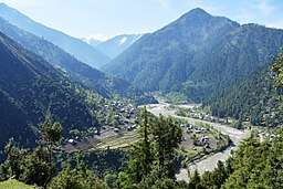
Neelum Valley
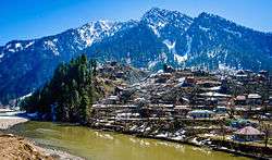
The Neelum Valley is a Himalayan gorge in the Kashmir region, along which the Neelum River flows. This green and fertile valley is 250 km in length and stretches its way from Muzaffarabad all the way to Athmuqam and beyond to Taobutt. It is one of the most attractive tourists places, like Swat and Chitral, but due to poor road system is yet veiled to the outside world. This area was badly affected by the 2005 earthquake and was cut off from the outside world as the roads and paths were filled with rubble. Now construction of an international standard road is in progress.
There are two entrances for Neelum valley, one Neelum Road by Muzaffarabad and the other by Kaghan the Jalkhad Road. Generally Neelum valley starts just after Muzaffarabad but in political division the area from Muzaffarabad to Chelhana is named Kotla valley in election division. District Neelum starts from Chelhana and goes to Taobutt.
Shardadesh is a name for the drainage basin of the Neelum River.
Dam
In the Indian state of Jammu and Kashmir, the construction work on the 330 MW Kishanganga Hydroelectric Plant project has started, after being defunct for eighteen years.[7][8] Recently, the project was awarded to Hindustan Construction Company (HCC) with a timeline of seven years. The 330 MW Kishanganga hydro-electric power project involves damming of Kishanganga or Neelam River and the proposed 37 metre reservoir will submerge some parts of the Gurez valley of Kashmir.[9] The water of Kishen Ganga River will be diverted through a 24 kilometre tunnel dug through the mountains to Bandipore where it will join the Wular Lake and then Jhelum River.[9]
Similarly, Pakistan is constructing the 969 MW Neelum–Jhelum Hydropower Plant; the country has placed the project in the hands of a Chinese consortium.[7] Pakistan claims that the Indian dam project will violate the Indus Waters Treaty and has pursued formal arbitration proceedings against India over the matter.[10][11]
See also
References
- ↑ Banerji, Arindam (20 June 2003). "The Neelam Plan". Rediff. Retrieved 15 August 2016.
The Neelam River enters Pakistan from India in the Gurais sector of the Line of Control, and then runs west till it meets the Jhelum north of Muzzafarabad.
- ↑ Majid Hussain (1998). Geography of Jammu and Kashmir. Rajesh Publications, 1998. p. 13–. ISBN 9788185891163. Retrieved 31 July 2012.
- ↑ "The Neelam Plan". Rediff. Retrieved 2009-11-15.
- ↑ "Basic Facts about the Kishenganga Dam ProjectK". Kashmir Environmental Watch Association. Archived from the original on 2010-08-31. Retrieved 2009-11-15.
- ↑ "Kashmiri refugees: facts issues and the future ahead". ips.org.pk. Retrieved 2012-02-21.
- ↑ "Gippsland Aquaculture Industry Network-Gain". growfish.com.au. Archived from the original on 2012-02-20. Retrieved 2012-02-22.
- 1 2 "Kishen Ganga power project to be revived". Chennai, India: The Hindu. 22 April 2008. Retrieved 2009-11-15.
- ↑ "Welcome to Kishenganga valley Project". NHPC Limited. Retrieved 20 December 2011.
- 1 2 "Kishen Ganga project to begin soon". The Indian Express. Archived from the original on 2012-10-01. Retrieved 2009-11-15.
- ↑ Pakistan Seeks Resolution of India Water Dispute. By TOM WRIGHT in Lahore, Pakistan, and AMOL SHARMA in New Delhi. Wall Street Journal. 20 May 2010.
- ↑ "Hague Court asks India to stop Kishanganga project". The International News. 25 September 2011. Retrieved 20 December 2011.