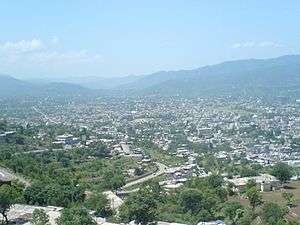
Kotli
| Kotli کوٹلی | ||
|---|---|---|
| City | ||
 | ||
| ||
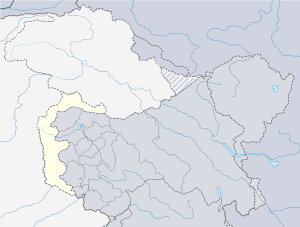 Kotli Location within Pakistan | ||
| Coordinates: 33°30′20″N 73°53′57″E / 33.50556°N 73.89917°ECoordinates: 33°30′20″N 73°53′57″E / 33.50556°N 73.89917°E | ||
| Country | Pakistan | |
| District | Kotli | |
| Constructed | Mid 15th Century | |
| Union Council |
18 UC (District Govt. system yet to be placed) | |
| Government | ||
| • Chief Commissioner | ||
| Area | ||
| • Total | 1,862 km2 (719 sq mi) | |
| Highest elevation | 3,000 m (10,000 ft) | |
| Population (2014)[1] | ||
| • Total | 774,194 | |
| • Density | 420/km2 (1,100/sq mi) | |
| Time zone | UTC+5 (PST) | |
| Postal Code | 11100 | |
| Area code(s) | 0092-58264 | |
| Website | District Website | |
Kotli (Urdu: کوٹلی) is the chief town of Kotli District, in Azad Kashmir, a self-governing region administered by Pakistan. Kotli is linked with Mirpur by two metalled roads, one via Rajdhani, (90 km) and the other via Charhoi. It is also directly linked with Rawalakot via Tarar Khel (82 km) and a double road which links Kotli with the rest of Pakistan via Sehnsa, another major town in Azad Kashmir. Kotli is roughly a three hours drive from Islamabad and Rawalpindi, at a distance of 117 km via Sehnsa.
History
As stated in History of the Punjab Hill States by J.Hutchinson and J.P. Vogel: "Kotli was founded about the fifteenth century by a branch of the royal family of Raja Mangar Pal . Kotli and Poonch remained independent until subdued by Ranjit Singh in 1815 and 1819 respectively."
The royal family of Hutchinson and Vogel are referring to is the family of Raja Mangar Pal. Before its name was Kohtali mean (under mountain) after that people changed its name to Kotli. Kotli is the largest district of Azad Jammu and Kashmir in terms of population.
Modern Kotli

Notable places in Kotli to visit are Sarda Point, Tinda Rest-House, Hill kalaan, near river Gori Park, Roli Hills, Butt Fire and Peer Lasura (Nakyal). Today kotli is shaping itself in almost every field of life. Some notable places are Gulhar Colony, Khuiratta, Chowki Tinda, Kurti, Roli, Brali, Dhamol, Qumrooti, Khad Gujran and OLakar village of the late Nambardar Allah Ditta, Sarhota and Samror. The town has become a vision of three-storey mansions that have taken over the once-barren roads between the outer ring villages and the ever-expanding city sitting on the brim of the Poonch River. The most famous and notable buildings are the three Khan-Wali fortresses, Jame Masjid Ghosia Balyah and Tehsil Guest House (Some Great people used to stay there since it was built by Dogra rulers).
The main distinction to the city is Jamay Masjid Al-Firdous Gulhar. It is the religious centre of excellence and it centralizes more than seven hundred mosques all over the world, the most of which are in Azad Kashmir. Khawaja Muhammad Sadiq laid foundation of this system and now his son Mr. Haafiz Muhammad Zahid Sultani is supervising the system efficiently.
The mass emigration that took over the country in the 1960s has now created a steady boom of summer holiday makers from Britain and beyond who seek to reconnect their European-born children to the old country. Kotli has international links throughout Western Europe and North America. Like many Azad Kashmiris (Poonch valley — a region found in the Jammu part of Jammu and Kashmir) living in the fringes of the Mangla Dam in Mirpur, emigration fever took hold of the surrounding country from the mid 1950s onwards.
Kotli has ties with many European cities such as Amsterdam, Hamburg and especially the larger industrial cities of northern and central England. Many Kotli city residents have ties to British nationals in the city of Manchester, Sheffield, Leeds, Bradford, Luton, Bedford, Watford and Birmingham. Kotli is also known as the city of mosques due to the fact that there are more than three hundred mosques in Kotli.
Faizan Rehman is currently the territory executive for Kotli district.
Famous Pakistani Leading Brand Firdous cloth Mills open its Outlet in Kotli. Firdous is famous for its lawn.
Indo-Pakistan War of 1947–48
In November 1947, the Indian Army reached Kotli and evacuated the garrisons of the town. The Pakistani Army along with the local population and aided by the tribesmen of the North West Frontier Province arrived and counter-attacked, forcing the Indian Army to abandon it. Kotli has been under Pakistani administration since.
Communications
- Three privately owned cable television systems: Apex World Cable Network covering 90% area of Kotli City and surroundings, Family Cable Network, and Medialink Cable Network, are available in Kotli, which transmit Pakistani and international television programs.
- A local FM radio station also broadcasts at FM 96.5.
- Cell phone service is available through six private cell phone operators: Zong, Jazz, Ufone, Telenor and SCOM. PTCL Wireless Evo broadband is also available.
- 4G internet services are now available with SCOM and Telenor.
See also
References
- ↑ "City (town) Kotli Loharan: map, population, location". www.tiptopglobe.com.
External links
- Daily News & Photos from Kotli Azad Kashmir
- Azad Jammu & Kashmir – Tourism in Kotli District
- Hydropower Potential in AJK U.K based report
- Success in Kashmir earthquake response
| Mirpur |
| ||||||||
|---|---|---|---|---|---|---|---|---|---|
| Muzaffarabad |
| ||||||||
| Poonch |
| ||||||||