Charsadda
| Charsadda چارسده | |
|---|---|
| District Headquarter / City | |
 Bacha Khan Chowk | |
 Charsadda  Charsadda | |
| Coordinates: 34°9′0″N 71°44′0″E / 34.15000°N 71.73333°ECoordinates: 34°9′0″N 71°44′0″E / 34.15000°N 71.73333°E | |
| Country |
|
| Province |
|
| District | Charsadda |
| Tehsil | Charsadda |
| Population (2017)[1] | |
| • Total | 114,565 |
| Time zone | UTC+5 (PKT) |
Charsadda (Pashto: چارسده ![]()
![]()
History
The earliest archaeological deposits recovered at Charsadda are dated to ca. 1400 BCE, constituting a series of post holes in association with ceramic sherds and ash. Subsequent periods indicate that more permanent structures were built at Charsadda, including stone-lined pits. Between the 14th century BCE and the 6th century BCE, when an Achaemenid presence is represented at the site (see below), the inhabitants of Charsadda developed an iron-working industry and used ceramics that are typical for this period in the Vale of Peshawar, Swat and Dir.
The father of Sanskrit grammar, Pāṇini was from this area and lived around 4th century BCE.
The later history of Charsadda can be traced back to the 6th century BCE. It was the capital of Gandhara from the 6th century BCE to the 2nd century CE. The ancient name of Charsadda was Pushkalavati. It was the administrative centre of the Gandhara kingdom. Many invaders have ruled over this region during different times of history. These include the Persians, Alexander the Great's Macedonians, the Mauryas, the Greco-Bactrians, the Indo-Greeks, the Indo-Scythians, the Indo-Parthians, the Kushans, the Huns, the Turks, the Guptas.
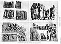 Buddhist statuary from Charsadda.
 Buddhist statues from Charsadda.
Charsadda is contiguous to the town of Prang; and these two places were identified by Alexander Cunningham with the ancient Pushkalāvati, capital of the region at the time of Alexander's invasion, and transliterated as Peukelaus or Peukelaotis by the Greek historians. Its chieftain (Astes), according to Arrian, was killed in defence of one of his strongholds after a prolonged siege by Hephaistion. Ptolemy fixes its site upon the eastern bank of the Suastene or Swat. The region was later conquered by Chandragupta Maurya from the Macedonian straps. In the seventh century CE Hiuen Tsiang visited the city, which he describes as being 100 li (16⅔ miles) north-east of Peshawar. A stupa, erected over the spot where Buddha made an alms-offering of his eyes, formed the great attraction for the Buddhist pilgrim and his co-religionists. The city, however, had even then been abandoned as a political capital in favour of Purushapura, Parashāwara, or Peshawar.[5]
Rivers
There are three rivers flowing in Charsadda: the River Jindi, the Kabul River and the Swat River; these are the main source of irrigation for Charsadda. The three rivers then merge and join the Indus River.[6]
Administration
The district is administratively subdivided into three tehsils which contained a total of 49 Union Councils.[2]
Recent history
In January 2016, Bacha Khan University was attacked with guns and bombs, killing 21 people and injuring 17. Four suspected attackers died in the battle.[7]
See also
References
- ↑ "POPULATION AND HOUSEHOLD DETAIL FROM BLOCK TO DISTRICT LEVEL: KHYBER PAKHTUNKHWA (Charsadda DISTRICT)" (PDF). 2018-01-03. Retrieved 2018-04-24.
- 1 2 Tehsils & Unions in the District of Charsada – Government of Pakistan Archived 22 March 2008 at the Wayback Machine.
- ↑ Location of Charsadda – Falling Rain Genomics
- ↑ "NWFP in search of a name". pakhtunkhwa.com. Archived from the original on 31 January 2016. Retrieved 24 January 2016.
- ↑ Chārsadda Town – Imperial Gazetteer of India, v. 10, p. 181.
- ↑ Noreen Haider. "Living With Disasters" (PDF). Archived from the original (PDF) on 9 July 2011. Retrieved 2010-06-01.
- ↑ Pakistan attack: Gunmen kill 19 at Bacha Khan University BBC