Kotli District
| Kotli | |
|---|---|
| District | |
 | |
 Map of Azad Kashmir with Kotli highlighted | |
| Coordinates: 33°09′01″N 73°45′12″E / 33.1502°N 73.7532°ECoordinates: 33°09′01″N 73°45′12″E / 33.1502°N 73.7532°E | |
| Country | Pakistan |
| Province | Azad Kashmir |
| Established | 1975 |
| Headquarters | Kotli |
| Area | |
| • Total | 1,862 km2 (719 sq mi) |
| Population (1998) | |
| • Total | 640,000 |
| • Density | 352/km2 (910/sq mi) |
| Time zone | UTC+5 (PST) |
| Number of Tehsils | 5 |
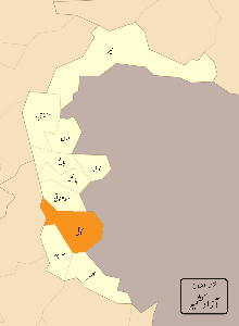
Kotli District (Urdu: ضلع کوٹلی) is one of ten districts of Azad Kashmir, Pakistan. Kotli is the chief town of the district.[1]
Administrative divisions
The district of Kotli used to be a sub-division of Mirpur District until 1975. Before 1947, it was a part of the Jammu area. The district is bounded by the Indian part of Kashmir in the east, and by Mirpur District in the south and Rawalakot to its north. The district is divided into 4 tehsils (sub-divisions):
Education
According to Pakistan District Education Ranking 2017, a report released by Alif Ailaan, the district of Kotli stands at number 7 nationally relating to education with a score of 73.7.The learning score stands at 85.67 and gender parity is at 93.45.
According to the same report ,district Kotli is ranked at 119 nationally with a readiness score of 35.47 and retention score of 35.36. The learning score is low because of lack of quality teachers and no proper formal teacher training. The retention score is low because of low number of beyond primary schools.
When it comes to infrastructure , Kotli ranks at 154 , which is the second lowest with a score of 14.14. This shows there is a serious problem and lack of provision of basic facilities like electricity , functional toilets , furniture and lack of boundary walls. For more detailed insight , visit TaleemDo! App.
See also
References
External links
- Azad Jammu and Kashmir Govt. Kotli page

Provincial capital: Muzaffarabad | ||
| Muzaffarabad | 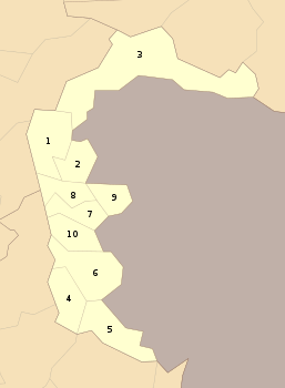 | |
| Poonch | ||
| Mirpur | ||