Bhimber District
| Bhimber ضلع بھمبر | |
|---|---|
| District | |
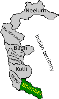 Map of Azad Kashmir with Bhimber highlighted | |
| Country | Pakistan |
| Province | Jammu and Kashmir |
| Established | 1996 |
| Headquarters | Bhimber |
| Area | |
| • Total | 1,516 km2 (585 sq mi) |
| Population (2017) | |
| • Total | 420,624 |
| • Density | 277/km2 (720/sq mi) |
| Time zone | UTC+5 (PST) |
| Number of Tehsils | 3 |
| Website | http://www.bhimber.com |
Bhimber (Urdu:ضلع بھمبر) is the southernmost of the ten districts of Azad Jammu and Kashmir. It borders Indian-administered Kashmir to the east. The district is located between Latitude: 32-48 to 33-34 and Longitude: 73.55 to 74-45, and has an area of 1516 km². The chief town is Bhimber.
History
The area is very rich in archaeological remains due to its strategic location. It lies on the route that was followed by the Mughal Emperors for their frequent visits to the Kashmir Valley.Due to such important location it was called Gateway to Kashmir (Bab-e-Kashmir).
Until 1995 Bhimber was a sub-division (tehsil) of Mirpur District. In 1996 the Tehsil of Bhimber was removed from Mirpur and made into a separate district.
Location
The district is bounded by Mirpur district to the northwest (and is 50 km from Mirpur city), and Punjab province in the west and south. It also shares borders with Indian administered Kashmir to the east.
Administrative divisions
The total area of the district is 1516 square kilometres and is sub-divided into three tehsils:
Demography
According to the 2017 census, the total population of the district stands at 420,624.[1]
Education
According to the Alif Ailaan Pakistan District Education Rankings 2015, Bhimber ranked 10th out of 145 districts in Pakistan in terms of education. For facilities and infrastructure, the district is ranked 116 out of 145.[2]
Climate
The southern zone Mirpur Division has a similar climate to the neighbouring areas of Punjab, hot summer temperature is often over 45 C from May to September and cold winter, rainfall is concentrated in the monsoon from late June to the end of August. There is often a prolonged dry period from October to early January followed by Winter rains from mid-January to March.
References
- ↑ "Census 2017: AJK population rises to over 4m". The Nation. Retrieved 2017-09-01.
- ↑ "Individual district profile link, 2015". Alif Ailaan. Retrieved 2015-05-06.
External links
- Bhimber Azad Kashmir Public website
- Bhimber district page by the Government of Azad Kashmir

Provincial capital: Muzaffarabad | ||
| Muzaffarabad |  | |
| Poonch | ||
| Mirpur | ||