Gujrat City
| Gujrat گُجرات | |
|---|---|
| City | |
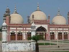 Gujrat's Eid Gah mosque dates from the Mughal era | |
 Gujrat  Gujrat | |
| Coordinates: 32°34′26″N 74°4′44″E / 32.57389°N 74.07889°ECoordinates: 32°34′26″N 74°4′44″E / 32.57389°N 74.07889°E | |
| Country | Pakistan |
| Province | Punjab |
| District | Gujrat |
| Government | |
| • Deputy Commissioner | Muhammad Ali Randhawa |
| • District Police Officer | Sohail Zafar Chatha |
| Time zone | UTC+5 (PST) |
| Calling code | 053 |
| Number of Union councils | 18[1] |
Gujrat (Punjabi, Urdu: گُجرات), is a city in Punjab Province of Pakistan.[2] It is the capital of Gujrat District and the 18th largest city of Pakistan.[1] Along with the nearby cities of Sialkot and Gujranwala, Gujrat forms part of the so-called Golden Triangle of industrial cities with export-oriented economies.[3][4]
History
The area around Gujrat was settled during the Sher Shah Suri period, immediately prior to Mughal rule.[5] The area was named Khwaspur,[5] in honour of Suri's Governor of Rohtas, Khwas Khan. Local traditions state that Gujrat is the second town to be built in the area, with the first having been destroyed by Mongol invasions in 1303.[6]
The city was further developed during the reign of Mughal Emperor Akbar, who built the Gujrat Fort in 1580,[7] and compelled local Gujjars to settle in the city in 1596-97.[5][8] The city was then named in reference to the Gujjar tribes.[5] In 1605, the city Syed Abdul Kasim was granted the city as a fief by Akbar.[5]
During the reign of Emperor Jahangir, Gujrat was part of the route used by Mughal royals when visiting Kashmir.[9] Gujrat's most famous saint, Shah Daula, is credited with having saved Gujrat from the wrath of Sikh Guru Hargobind when he stayed in the city upon his return from Kashmir in 1620.[8] During the Mughal era, Gujrat was encircled by a wall with 5 gates, of which only the Shah Daula gate survives.[10]

Following the decline of the Mughal Empire after the death of Aurangzeb in 1707, the region's security situation declined. Gujrat was sacked by Afsharid Persian Emperor Nader Shah during his invasion of the Mughal Empire.[5] Shortly afterwards in 1741, the city was captured by Gakhar tribes from near the Rawalpindi area.[6] The city further suffered from the invasions of Ahmad Shah Durrani in the mid 1700s.[5]
In 1765, the city was overrun by the Bhangi Sikhs under Sardar Gujjar Singh.[6] The Sikhs defeated an Afghan force in a battle for Gujrat on 29 April 1797.[11] In 1798, the Bhangi leader Sahib Singh pledged allegiance to the Sukerchakia Misl of Ranjit Singh.[5] In 1810, Ranjit Singh's armies captured the city from Bhangi forces, thereby extending the rule of the Sikh Empire to the city.[5]
Gujrat finally came under British influence in 1849, following the collapse of the Sikh Empire in the wake of the Sikh's defeat at the Battle of Gujrat on 22 February, which ended the Second Anglo-Sikh War.[5] In 1867, Gujrat was constituted as a municipality.[7]
Geography
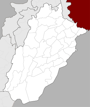
Gujrat is an ancient city of Pakistan located between two famous rivers, Jhelum River and Chenab River. It is bounded to the northeast by Jammu and Kashmir, to the northwest by the Jhelum River, to the east and southeast by the Chenab River, separating it from the districts of Gujranwala and Sialkot; and to the west by Mandi Bahauddin District. Gujrat consists of three Tehsils which are Sarai Alamgir, Kharian and Gujrat.
Climate
| Climate data for Gujrat | |||||||||||||
|---|---|---|---|---|---|---|---|---|---|---|---|---|---|
| Month | Jan | Feb | Mar | Apr | May | Jun | Jul | Aug | Sep | Oct | Nov | Dec | Year |
| Average high °C (°F) | 19.2 (66.6) |
22.1 (71.8) |
27.4 (81.3) |
33.7 (92.7) |
39.1 (102.4) |
41.1 (106) |
36.3 (97.3) |
34.6 (94.3) |
35.1 (95.2) |
33.1 (91.6) |
27.2 (81) |
21.2 (70.2) |
30.8 (87.5) |
| Daily mean °C (°F) | 12.4 (54.3) |
15.1 (59.2) |
20.3 (68.5) |
26 (79) |
31.1 (88) |
34 (93) |
31.4 (88.5) |
30.2 (86.4) |
29.4 (84.9) |
25.3 (77.5) |
18.7 (65.7) |
13.5 (56.3) |
24 (75.1) |
| Average low °C (°F) | 5.6 (42.1) |
8.1 (46.6) |
13.3 (55.9) |
18.4 (65.1) |
23.2 (73.8) |
26.9 (80.4) |
26.6 (79.9) |
25.8 (78.4) |
23.8 (74.8) |
17.6 (63.7) |
10.2 (50.4) |
5.8 (42.4) |
17.1 (62.8) |
| Average precipitation mm (inches) | 38 (1.5) |
37 (1.46) |
36 (1.42) |
21 (0.83) |
19 (0.75) |
47 (1.85) |
182 (7.17) |
205 (8.07) |
83 (3.27) |
12 (0.47) |
5 (0.2) |
18 (0.71) |
703 (27.7) |
| Source: https://en.climate-data.org/location/964104/ | |||||||||||||
People from Gujrat
- Chaudhry Pervaiz Elahi, former Chief Minister of Punjab & Federal Minister, Speaker of Provincial Assembly of Punjab (from 16th,August 2018 to present & from 1997 – June 2001)
- Yasmin Qureshi, British MP
- Rizwan Cheema, Canadian cricketer
- Ejaz Durrani, Pakistanin actor
- Chaudhry Zahoor Elahi, Pakistani politician
- Moonis Elahi, politician
- Anwar Masood, poet
- Ismat Beg, Scientist
- Aitzaz Ahsan, barrister
- Chaudhry Ahmed Mukhtar, Former Minister for Defense, Government of Pakistan
- Chaudhry Muhammad Jaffar Iqbal, Vice-President of PML-N Punjab
- Chaudhry Shujat Hussain, former Prime Minister of Pakistan
- Fakhar Zaman, poet and scholar
- Fazal Ilahi Chaudhry, President of Pakistan 1972–1977
- Mian Imran Masood, former MPA of Gujrat and Minister of Education Punjab.
- Mian Muhammad Afzal Hayat, former Chief Minister of Punjab and served as ambassador in different countries
- Nawabzada Gazanfar Ali Gul, former Federal Minister of Pakistan
- Orya Maqbool Jan, columnist
- Qamar Zaman Kaira, politician
- Raheel Shareef, Chief of Army Staff of the Pakistan Army
- Raja Aziz Bhatti, Nishan-e-Haider (Highest Military Decoration), Major Shaheed 1965 Indo-Pak war
- Sabiha Khanum, actress
- Shabbir Sharif, Nishan-e-Haider (Highest Military Decoration), Martyred Major of the 1971 Indo-Pak war
- Sharif Kunjahi, Punjabi poet
- Alam Lohar, Punjabi Folk Singer
- Arif Lohar, Folk singer
- Albert Naseem, Colonel Pakistan Army
References
- 1 2 "Tehsils & Unions in the District of Gujrat – Government of Pakistan". Archived from the original on 14 February 2009.
- ↑ Google maps. "Location of Gujrat". Google maps. Retrieved 23 September 2013.
- ↑ Mehmood, Mirza, Faisal; Ali, Jaffri, Atif; Saim, Hashmi, Muhammad (2014-04-21). An assessment of industrial employment skill gaps among university graduates: In the Gujrat-Sialkot-Gujranwala industrial cluster, Pakistan. Intl Food Policy Res Inst. p. 2.
- ↑ Naz, Neelum. "Historical Perspective of Urban Development of Gujranwala". Dept. of Architecture, UET, Lahore. Retrieved 22 December 2017.
- 1 2 3 4 5 6 7 8 9 10 "Imperial Gazetteer2 of India, Volume 12, page 365 -- Imperial Gazetteer of India -- Digital South Asia Library". dsal.uchicago.edu. Retrieved 2018-02-02.
- 1 2 3 Americanized Encyclopaedia Britannica: Rev. and Amended A Dictionary of Arts, Sciences and Literature, to which is Added Biographies of Living Subjects. 96 Colored Maps and Numerous Illustrations. Belford-Clarke Company. 1890.
- 1 2 "Gujrat | Pakistan". Encyclopedia Britannica. Retrieved 2018-02-02.
- 1 2 Malhotra, Anshu; Mir, Farina (2012-02-21). Punjab Reconsidered: History, Culture, and Practice. Oxford University Press. ISBN 9780199088775.
- ↑ Bhat, Muzaffar (2017-09-22). "The Mughal road to Srinagar". The Friday Times. Retrieved 2018-02-02.
- ↑ "Last vestige of Mughal era in Gujrat | ePaper | DAWN.COM". epaper.dawn.com. Retrieved 2018-02-02.
- ↑ Jaques, Tony (2007). Dictionary of Battles and Sieges: F-O. Greenwood Publishing Group. ISBN 9780313335389.