Bagh, Azad Kashmir
| Bagh باغ | |
|---|---|
| City | |
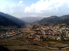 Bagh city view | |
 Bagh | |
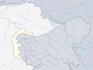
| Coordinates: 33°58′25″N 73°47′30″E / 33.9735°N 73.7918°ECoordinates: 33°58′25″N 73°47′30″E / 33.9735°N 73.7918°E | |
| Country |
|
| State | Azad Kashmir |
| District | Bagh |
| Area | |
| • Total | 768 km2 (297 sq mi) |
| Elevation | 1,676 m (5,499 ft) |
| Population (2017) | |
| • Total | 371,919 |
| • Density | 480/km2 (1,300/sq mi) |
| Languages | |
| • Official | Urdu |
| Time zone | PST |
| GPO | 12500 |
| Website | http://www.bagh.com.pk |
Bagh City (Urdu: باغ ) is the chief town and district headquarters of Bagh District, in Azad Kashmir, Pakistan. The town is situated on the confluence of two nullahs (streams), Malwani and Mahl (ماہلوانی اور ماہل)at the distance of 93 km from Muzaffarabad. City played a role in freedom of Azad Kashmir.
The first fight between the Hindu Dogra Army and Muslim freedom protesters was started here. When some Muslims were protesting against the Hindu Maharaja, the army of the Maharaja fired on innocent Muslim protesters at Huda Bari (ہودا باڑی) at Bagh. Syed Khadim Hussain of village Hullay Sayyedan Bagh was martyred at Huda Bari and acknowledged as Shaheed e Awwal. After that incident, the local Muslims decided to fight against the Hindu Maharaja's forces. The next day, they planned a meeting at Neela Butt Mountain (نیلا بٹ پہاڑی) for the strategy of fighting against the Hindu Maharaja. This meeting was led by Sardar Abdul Qayyum, also called Mujahid e Awal (later when some part of Kashmir was free from Hindu Maharaja and Indian forces).
Language and history
Pahari and Gojri are the predominant languages spoken in Bagh.
Before getting the status of an independent district in 1987, Bagh was a part of District Poonch. This is also the birthplace of the forgotten pooch rebellion. the natives rebelled against the maharaja rule when their weapons were collected by the authorities and redistributed among the Sikh and Hindus. This was done because in 1947 there were 50,000 Poonchis who had served in the British Army. Poonch was one of the major recruiting grounds for the British. These people would always think of themselves as fighters. There were no economic opportunities and inadequate landholdings in this area.
Armed rebellion started in the Poonch district at the beginning of October 1947. The first Shaheed was in Bagh a place called Hodda Bari where the troops of the Maharaja Opened fire on the protests and hoisting of the Pakistani flag. The Muslim Conference sources narrate that hundreds of people were killed in Bagh during flag hoisting around 15 August and that the Maharaja unleased a 'reign of terror' on 24 August. Local Muslims also told Richard Symonds, a British Quaker social worker, that the army fired on crowds, and burnt houses and villages indiscriminately. Tribesmen made commities with each other's villages to form defensive forces. Many women and children had to hide in the jungles and mountains surrounding Bagh for days fearful of attacks by the Sikh villagers.
The Sikh villages that were left behind were taken into the Batul-Mal and later distributed to the people coming from other areas of Kashmir.
2005 earthquake
On 8 October 2005, Bagh was hit by a devastating earthquake that killed 8,500 people, which represented 10% of the population.[1] Most of the victims were children attending school who died when the school buildings collapsed. The worst hit institutes were a school named Spring Field Children academy ( where 300 plus children died in junior campus),the boys' degree college and girls' degree college Bagh. Many lives could have been saved if the rescue equipment was available. The entire city was destroyed and is rebuilt with the help of government.
Geography
Bagh is located 80 kilometres from Muzaffarabad, the capital city of Azad Kashmir. It is 160 kilometres from Islamabad, the capital of Pakistan.[2]
The town is situated on the confluence of two mini nullahs (streams), Mahlwani and Mahl, which flow all year round. The locally recognized Haji Peer Pass is about 32 kilometers from Bagh City. In 2011–2012, the population was 87,523. Middle-standard hotels and forest rest-houses are available for visitors, and necessities are available in the Bagh bazaars.
Topographically, the district is quite mountainous with lush green pine forests on the mountain slopes leading into the valleys. The altitude of Bagh Valley is 3405 feet (1038m). Usually in the summer most people move up into the higher valleys where the snows have melted for pleasant weather and better grazing for their animals. The Bakerwals from all over AJK and Pakistan descend upon Bagh with their animals and families as soon as the snows melt.
Tourism
Ganga Choti is a mountain of 9000 ft. Many tourists visit it very year. This mountain is 30 km from Bagh City.[2]
There are many places of interest to tourist coming to Bagh such as the river mall which runs through the middle of Bagh. It is well stocked with trout fish and small crabs and wild birds can also be seen there throughout the seasons. Fishing is only permitted in the winter months and the mall has access from the main artery road connecting Bagh which runs parallel to the river. Sharki Bagh has some scenic routes crossing small streams and rivers. The main highway Dholli Road leads to Las Danna located 15 kilometers from Bagh city at the height of 8,612 feet. Tourists visit this area for its climate and views. A tourist rest house and restaurants are located here. The road that goes left from Las Danna crossing leads to the Haji Peer pass (8651.57 feet). In route to the pass the Pir Panjal mountain range can be seen. The road going right from Las Danna leads to Mehmood Gali another high point, this road leads to Zila Kahota. The city of pooch can be seen from here however the army will only allow access to certain places as this is on the Line of control. Another destination is Pir Kanthi (10895.67 feet), known for its views and natural herbs. A number of herders come to Mir Kanthi in the summer months for the grazing grounds in Bagh. Panjal Mastan park stretches from Ganga Choti to Pir Kanti and has many places of interest; however, it is not inhabited by many people and has an off-road dirt tract. There is an abundance of wildlife including the infamous mountain leopard unfortunately there have been events where these stunning creatures have strolled into settled areas and have been killed by the locals. In higher altitudes you can find monkeys of three different kinds and a wide variety of pheasants and other birds. There have been sightings of musk deer but in very remote places high in the mountains.
Dhirkot is another town located in Garbi Bagh bordering Punjab and KPK provinces of Pakistan. This is where the headquarters of the uprising was based.
References
- ↑ World Bank – Pakistan Earthquake, A Year After
- 1 2 Bagh, Pakistani Tourism
External links
| Wikivoyage has a travel guide for Bagh. |
| Mirpur |
| ||||||||
|---|---|---|---|---|---|---|---|---|---|
| Muzaffarabad |
| ||||||||
| Poonch |
| ||||||||