Sargodha
| Sargodha سرگودھا | |
|---|---|
| City District / Divisional Capital | |
    | |
 Sargodha  Sargodha  Sargodha .svg.png) Sargodha | |
| Coordinates: 32°5′1″N 72°40′16″E / 32.08361°N 72.67111°ECoordinates: 32°5′1″N 72°40′16″E / 32.08361°N 72.67111°E | |
| Country | Pakistan |
| Province | Punjab |
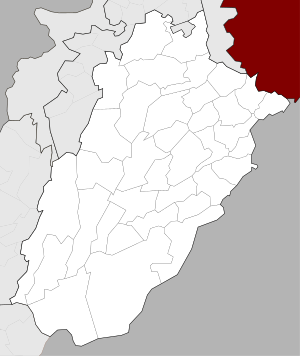
| Division[1] | Sargodha |
| District | Sargodha |
| Government | |
| • Commissioner | Captain Muhammad Asif |
| Area | |
| • Total | 5,854 km2 (2,260 sq mi) |
| Population (2017)[2] | |
| • Total | 659,862 |
| • Rank | 12th (Pakistan) |
| • Density | 110/km2 (290/sq mi) |
| Time zone | UTC+5 (PST) |
| Postal code | 40100[3] |
| Dialling code | 048[4] |
| Number of towns | 59 |
| Number of union councils | 22 |
| Website |
www |
Sargodha (Punjabi and Urdu: سرگودھا) is the 12th largest city in Pakistan with a population of around 650 000.[5] It is also an administrative centre of Sargodha Division located in the Punjab province, Pakistan and one of the fastest growing cities in Pakistan.[6]
History

Sargodha was established by the British as a canal-colony in 1903, and was initially spelt Sargoda.[7] Sargodha was badly affected by an outbreak of the plague in 1903, and experienced a milder outbreak in 1904.[8] Although it was a small town in the beginning, the British Royal Air Force built an airport here due to its strategic location.[9]
Geography
Location
Sargodha is located 172 kilometres northwest of Lahore, in Sargodha District. It lies about 30 miles from the M-2 motorway, which connects Lahore and Islamabad. It is connected to the M-2 by several interchanges at different locations. Sargodha is roughly 94 km from Faisalabad, due southeast. Directly east connected by the M-2 motorway are Lahore and the route to Rawalpindi and Islamabad. Due east is the city of Jhang; toward the west are the city of Mianwali and the Chashma Barrage. Dera Ismail Khan is located 232 km southwest from the city.
Topography
Sargodha mainly comprises flat, fertile plains, although here are a few small hills on the Sargodha-Faisalabad Road. The River Jhelum flows on the western and northern sides, and the River Chenab lies on the eastern side of the city.[10] The city is located 190 metres above sea level.[11]
Climate
The city has a climate of extreme heat in the summers and moderate cold in the winters. The maximum temperature reaches 50 °C (122 °F) in the summer while the minimum temperature recorded is as low as freezing point in the winter.
| Climate data for Sargodha (1960–2012) | |||||||||||||
|---|---|---|---|---|---|---|---|---|---|---|---|---|---|
| Month | Jan | Feb | Mar | Apr | May | Jun | Jul | Aug | Sep | Oct | Nov | Dec | Year |
| Average high °C (°F) | 20 (68) |
22 (72) |
26 (79) |
32 (90) |
38 (100) |
39 (102) |
38 (100) |
37 (99) |
36 (97) |
32 (90) |
26 (79) |
22 (72) |
30.6 (87.1) |
| Average low °C (°F) | 8 (46) |
11 (52) |
15.5 (59.9) |
19 (66) |
25 (77) |
27 (81) |
26 (79) |
26 (79) |
25 (77) |
20 (68) |
14 (57) |
9 (48) |
18.8 (65.8) |
| Average precipitation mm (inches) | 18 (0.71) |
36 (1.42) |
24 (0.94) |
13 (0.51) |
17 (0.67) |
48 (1.89) |
82 (3.23) |
87 (3.43) |
43 (1.69) |
9 (0.35) |
11 (0.43) |
12 (0.47) |
400 (15.74) |
| Average precipitation days (≥ 1.0 mm) | 5 | 4 | 5 | 4 | 3 | 3 | 7 | 7 | 4 | 1 | 1 | 1 | 45 |
| Source: Weather2,[12] | |||||||||||||
Demographics
Total population of the city was 458,440[13] according to the 1998 census. The majority of the people in the city speak Punjabi.[9]
Administration
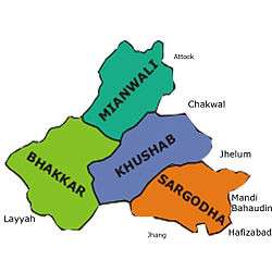
Sargodha is the capital of Sargodha Tehsil. As of October 2012, the division system in Punjab Province has been restored and Sargodha became the divisional headquarters of districts Sargodha, Khushab, Mianwali and Bhakkar. The city of Sargodha is administratively subdivided into 22 union councils.[14]
Education

Colleges and Universities in Sargodha
- University of Sargodha
- University College of Agriculture
- University of Lahore, Sargodha Campus
- Sargodha Medical College
- Airbase Inter College (ABICS)
- Army Public College, Sargodha
- Cornelius Law College
- Logix College
- Quaid-e-Azam Law College
- Sargodha Institute of Health Sciences
- Sargodha Institute of Technology
- The Superior College Sargodha
- Reader college Sargodha
- Acme College of Excellence Sargodha
- Punjab College of Science
- Divisional Public College [15]
Schools
- Sanai School System
- Divisional Public School, Sargodha[16]
- Beaconhouse School System
- Dar-e-Arqam Schools
- PAF Public School
- Presentation Convent High School
- Army Public School, Sargodha
- Lasani Grammar High School
- Government Junior Model Secondary School
- Air Base Inter School (ABICS)
- Progressive Public School, Sargodha
- The Right School (Shaheen Campus) Sargodha
Transportation
Road
Sargodha lies about 30 miles (48 km) from the M-2 motorway which connects Lahore and Islamabad. It is also connected to Faisalabad by a highway. Daewoo Bus Service drives regular routes from Sargodha to the rest of the country.[17]
Rail
Sargodha is also connected by the rest of the country through the rail.[18] Sargodha Junction railway station is located on Shorkot-Lala Musa branch railway line.
Sports
Sargodha is home to the Sargodha Cricket Stadium.[19] Sargodha cricket team were a first-class cricket team that represented Sargodha Division in Punjab Province in Pakistan. They competed in Pakistan's first-class tournaments between 1961-62 and 2002-03. Mela Mandi Ground is a multi-use historic stadium in Sargodha, Punjab, Pakistan. It is currently used mostly for cricket and football.[20] The Mela Mandi Ground was constructed to provide a vast ground for outdoor sports and activities. During March every year which is the country’s spring season, several competitions are held here. Almost all Pakistani people join these annual games.[21]
Air Base
Pakistan's largest airbase, PAF Base Mushaf (formerly PAF Base Sargodha), is situated in Sargodha and hosts the headquarters of the Pakistan Air Force's Central Air Command. The airbase is also home to the Combat Commanders School (CCS), formerly the Fighter Leader's School.[22]
Tourist attraction
The Kirana Hills is a small and extensive rocky mountain range located in Sargodha.[23][24][25][26] It is also a place of tourist attraction in Sargodha City. Jinnah Hall is a historical landmark and point of interest in Sargodha.[27] Jinnah Hall was built in 1972. It was named for the Founder of Pakistan, Muhammad Ali Jinnah.
Notable people
- Feroz Khan Noon, former Prime Minister Pakistan
- Anwer Ali Noon, former Parliamentarian of Pakistan and army Officer
- Amjad Ali Noon, former Ambassador/High Commissioner of Pakistan
- Imtiaz Bhatti, former Ambassador / High Commissioner of Pakistan
- Wazir Agha, Urdu Scholar
- Hameed Gul, former ISI Chief
- Ch. Anwar Ali Cheema, politician, PML-Q
- Ch.Ghias Mela, politician, PML-Q
- Hafiz Muhammad Saeed, Amir Jama'at-ud-Da'wah
- Mohammad Hafeez, cricketer
- Aizaz Cheema, cricketer
- Rafiq Anjum, actor
- Jahanzeb Qamar, television writer
References
- ↑ "Sargodha Division". getamap.net.
- ↑ http://www.citypopulation.de/Pakistan-100T.html
- ↑ "Pakistan Post Office Department". Archived from the original on 20 December 2011. Retrieved 12 March 2016.
- ↑ "National Dialing Codes". Retrieved 12 March 2016.
- ↑ http://www.citypopulation.de/Pakistan-100T.html
- ↑ "Commercial Real Estate Property in Sargodha Pakistan - Ghar47". Ghar47. Archived from the original on 16 February 2016. Retrieved 12 March 2016.
- ↑ Masud, Tariq (1989). Pakistan: a historical and cultural panorama. Al-Waqar Publishers. ISBN 9789698054021.
- ↑ Cell, John W.; Cell, John Whitson (2002-08-22). Hailey: A Study in British Imperialism, 1872-1969. Cambridge University Press. ISBN 9780521521178.
- 1 2 "District Website". lhc.gov.pk.
- ↑ "District at Glance". sargodha.gop.pk. Archived from the original on 26 June 2015.
- ↑ "Where is Sargodha, Pakistan?". WorldAtlas. Retrieved 2018-02-17.
- ↑ "Weather2 – Sargodha". Retrieved 8 July 2012.
- ↑ "Population size and growth of major cities" (PDF). Pakistan Bureau of Statistics. 1998.
- ↑ "Tehsils & Unions in the District of Sargodha - Government of Pakistan". Nrb.gov.pk. Archived from the original on 9 February 2012. Retrieved 15 March 2012.
- ↑ https://www.facebook.com/dpscollegesargodha/
- ↑ http://www.dpsc.edu.pk/
- ↑ http://www.daewoo.com.pk/terminal_view.asp?menu_set=5&submenu_set=1&page_title=Sargodha&terminal_code=13
- ↑ "Pakistan Railway Time Table". railpk.com.
- ↑ "Sports Stadium - Pakistan - Cricket Grounds - ESPN Cricinfo". Cricinfo.
- ↑ https://www.google.com/maps/place/Mela+Mandi+Ground/@32.0691594,72.6590951,15z/data=!4m5!3m4!1s0x0:0x3d77fd98247eb21f!8m2!3d32.0691594!4d72.6590951<
- ↑ http://www.flighthub.com/cheap-flights-to-Sargodha
- ↑ "About Sargodha". glowpakistan.com.
- ↑ (Mahajan 2009, pp. 100–110)
- ↑ (Ali 2002, pp. 25–26)
- ↑ (Smith 2007, pp. 92–93)
- ↑ Wikimaps. "Kirana Hills". http://wikimapia.org/. Wikimaps. Retrieved 14 June 2015. External link in
|website=(help) - ↑ "Google Maps". Google.com. Retrieved 2016-09-17.