Khuzdar
| Khuzdar خُضدار | |
|---|---|
| City | |
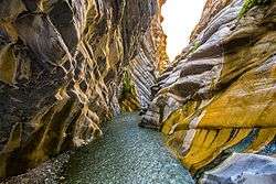 The Moola Chotok ravine near Khuzdar | |
 Khuzdar  Khuzdar | |
| Coordinates: 27°48′N 66°37′E / 27.800°N 66.617°ECoordinates: 27°48′N 66°37′E / 27.800°N 66.617°E | |
| Country |
|
| Province | Balochistan |
| Elevation | 1,237 m (4,058 ft) |
| Time zone | UTC+5 (PST) |
| Calling code | +92848 |
Khuzdār (Brahui/Balochi: خوزدار; Urdu: خُضدار) is the capital city of Khuzdar District in the central part of Balochistan Province, Pakistan. Historically, Khuzdar was the main city and capital of the Jhalawan province of the Khanate of Kalat. From October 1952 to 1955, it became part of the Balochistan States Union. In 1955, Khuzdar became the capital of the newly formed Kalat Division. Currently, Khuzdar is the third-largest city of Balochistan Province after Quetta and Turbat, and is also the largest Brahui-speaking city.
History
Khuzdar appears as Khnenta in the Zend Avesta and is one of the sixteen beautiful lands created by Ahura Mazda. Khuzdar was the capital of the Brahui kingdom of Makran.[1]
In the early 17th century it was part of the Jhalawan Kingdom, but it soon fell under the Khanate of Kalat, where it remained until a series of revolts during the reign of Khudadad Khan (1857–1893). By 1896, after Khudadad's death, the authority of Kalat was restored.[2] Khuzdar was the capital and largest city of the Jhalawan province of the Khanate of Kalat.
Under a treaty with Kalat, the British appointed a political agent at Khuzdar in 1903. British assistance continued until 1947, after which the area was acceded to Pakistan as part of the two nation theory and became a Democracy. When the Baluchistan States Union became Kalat Division, Khuzdar was established as the divisional headquarters. The divisional administration of Pakistan ended in 2000. Khuzdar was again established as the Divisional headquarters in June 2009 by the Pakistan Peoples Party Government.
Education
Khuzdar serves as the learning center for the Balochistan province. The city has a number of government and private colleges, including the following:
- Balochistan Residential College
- Balochistan University of Engineering and Technology
- Boys Degree College, Khuzdar
- Divisional Public School and College, Khuzdar
- Girls Degree College, Khuzdar
- Government College of Elementary Education (Women), Khuzdar
- Hamdam College of Education, Khuzdar
- Jhalawan Law College
- Jhalawan Medical College
- Lasbela University of Agriculture, Water and Marine Science, Khuzdar campus
- Pakistan Public School, Khuzdar
- Sardar Bahadur Khan Women's University, Khuzdar sub-campus
- Shaheed Sikander Zarakzai University, Khuzdar
- Sunrise Public School and College, Khuzdar
- Workers Model Higher Secondary School Khuzdar
Geography and climate
Khuzdar is at the apex of a narrow valley at an elevation of 1,237 metres (4,058 ft). Despite this altitude, Khuzdar like most of Balochistan has an arid climate (Köppen BWh) with very low and erratic rainfall. Unlike most parts of the province, the heaviest average rainfall comes from the Asian monsoon in July and August, though this rainfall tends to be very erratic and in many summers there is no significant rain at all.
| Climate data for Khuzdar | |||||||||||||
|---|---|---|---|---|---|---|---|---|---|---|---|---|---|
| Month | Jan | Feb | Mar | Apr | May | Jun | Jul | Aug | Sep | Oct | Nov | Dec | Year |
| Record high °C (°F) | 27.1 (80.8) |
28.4 (83.1) |
33.0 (91.4) |
37.2 (99) |
41.7 (107.1) |
43.0 (109.4) |
43.0 (109.4) |
42.0 (107.6) |
40.2 (104.4) |
38.0 (100.4) |
31.2 (88.2) |
28.0 (82.4) |
43 (109.4) |
| Average high °C (°F) | 17.0 (62.6) |
18.4 (65.1) |
23.5 (74.3) |
29.9 (85.8) |
35.0 (95) |
38.1 (100.6) |
36.2 (97.2) |
35.4 (95.7) |
34.0 (93.2) |
29.9 (85.8) |
24.9 (76.8) |
21.4 (70.5) |
28.6 (83.6) |
| Daily mean °C (°F) | 10.1 (50.2) |
11.7 (53.1) |
17.0 (62.6) |
23.2 (73.8) |
28.1 (82.6) |
31.3 (88.3) |
30.3 (86.5) |
29.3 (84.7) |
27.0 (80.6) |
21.9 (71.4) |
16.7 (62.1) |
11.9 (53.4) |
21.5 (70.8) |
| Average low °C (°F) | 3.2 (37.8) |
5.0 (41) |
10.7 (51.3) |
16.5 (61.7) |
21.3 (70.3) |
24.5 (76.1) |
24.3 (75.7) |
23.2 (73.8) |
20.1 (68.2) |
13.9 (57) |
8.4 (47.1) |
4.5 (40.1) |
14.6 (58.3) |
| Record low °C (°F) | −8 (18) |
−4.1 (24.6) |
0.6 (33.1) |
8.6 (47.5) |
11.0 (51.8) |
16.0 (60.8) |
17.0 (62.6) |
15.0 (59) |
12.8 (55) |
5.0 (41) |
1.0 (33.8) |
−6.1 (21) |
−8 (18) |
| Average rainfall mm (inches) | 16.9 (0.665) |
26.1 (1.028) |
27.7 (1.091) |
12.6 (0.496) |
13.1 (0.516) |
11.1 (0.437) |
47.7 (1.878) |
64.5 (2.539) |
6.4 (0.252) |
5.0 (0.197) |
5.7 (0.224) |
15.6 (0.614) |
252.4 (9.937) |
| Source: NOAA (1971–1990) [3] | |||||||||||||
References
- ↑ Risley, Herbert Hope (1903) Census of India, 1901. Volume I. India. Ethnographic appendices, being the data upon which the caste chapter of the Report is based Office of the Superintendent of Government Printing, Calcutta, page 66, OCLC 2196225
- ↑ Hughes-Buller, R. (ed.) (1908) Imperial gazetteer of India: Provincial Series: Baluchistan Office of the Superintendent of Government Printing, Calcutta, pages 16–17
- ↑ "Khuzdar Climate Normals 1971–1990". National Oceanic and Atmospheric Administration. Retrieved January 17, 2013.