Muzaffarabad District
| Muzaffarabad | |
|---|---|
| Districts of Azad Kashmir | |
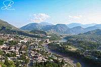 Muzaffarabad city, Pakistan | |
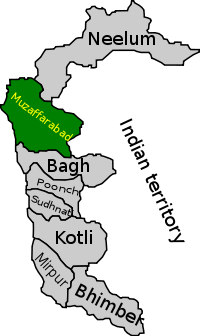 Map of Azad Kashmir with Muzaffarabad highlighted | |
| Country | Pakistan |
| Headquarters | Muzaffarabad |
| Government | |
| • District Nazim | Harris Bin Munir |
| • District Naib Nazim | N. Usama Latif |
| Area | |
| • Total | 1,642 km2 (634 sq mi) |
| Population (2017) | |
| • Total | 650,370 |
| • Density | 396/km2 (1,030/sq mi) |
| Time zone | UTC+05:00 (PST) |
| Number of Tehsils | 3 |
Muzaffarabad district (مُظفّر آباد) of Azad Kashmir, Pakistan is located on the banks of the Jhelum and the Neelum rivers, and is very hilly. The district is bounded to Punjab in the west and to Kupwara and Baramulla districts of the Kashmir in the east. To the north is Neelum District; the fall on the northeast of the district and Bagh District forms the southern boundary. The total area of the district is 1,642 square kilometres. The city of Muzaffarabad serves as capital of Azad Kashmir.
It is part of Muzaffarabad Division.
Language and demography
The total population of the district according to the 2017 Census its population stands at 650,370.[1]
The major language of the district is generally considered to be a variety of Pahari. Though occasionally referred to in the literature as Chibhali [2] or Poonchi,[3] it is locally known as Hindko.[4] Its speakers tend to identify more with the Hindko spoken to the west,[5] even though perceiving their speech to be only slightly different from the varieties of Bagh District and of the core Pahari areas further south in Murree.[6] The local dialect has a higher percentage of shared basic vocabulary with the central group of Pahari dialects (83–88%), than with the Hindko of nearby Mansehra and Abbottabad (73–79%).[7]
Another language spoken in the district is Gujari. The local dialect is closely related to the Gujari varieties spoken in Hazara (83–88% similarity in basic vocabulary) and the rest of Azad Kashmir (79–86%).[8] Kashmiri is spoken in the city of Muzaffarabad. It is distinct from, although still intelligible with, the Kashmiri of the Neelam Valley to the north.[9] Other languages spoken include Urdu, Shina and Balti.
Administrative divisions
The district of Muzaffarabad is administratively subdivided into three tehsils, which are sub-divided into 51 Union Councils[10]
- Muzaffarabad Tehsil
- Patehka (Nasirabad)
- Garhi Dupatta
- Tithwal Tehsil
Education
According to Pakistan District Education Ranking 2017, a report released by Alif Ailaan, Muzaffarabad is ranked at number 6 nationally with an education score of 73.85.
However when it comes to infrastructure, Muzaffarabad ranks at 105, with school infrastructure score of 34.29. There is a serious lack of electricity, drinking water and boundary wall with scores of 11.7, 27.93 and 40.09 respectively. Infrastructure wise , the schools are not conducive to study as they lack some of the basic facilities which should be present in a school.
72% of the schools are primary and only 28% are above primary. Therefore, students graduating out of primary schools , do not have sufficient post primary schools to attend. This leads to a steady decrease in enrollment over the classes, especially for girls.The issues on TaleemDo app also relates mainly to infrastructure as some complaint that there is no furniture and satisfactory building.
References
- ↑ "Census 2017: AJK population rises to over 4m". The Nation. Retrieved 2017-09-01.
- ↑ Grierson 1919, p. 505.
- ↑ Abbasi 2010, p. 104.
- ↑ Lothers & Lothers 2010, pp. 26, 80.
- ↑ Lothers & Lothers 2010, pp. 80, 108.
- ↑ Lothers & Lothers 2010, pp. 80, 86.
- ↑ Lothers & Lothers 2010, p. 24–25.
- ↑ Hallberg & O'Leary 1992, pp. 107, 111–12. For comparison, the shared basic vocabulary with the dialects spoken in the northernmost districts of Khyber Pakhtunkhwa and Gilgit, is between 71–74%, with the Hindko of Balakot: 80% and with Urdu: 57%.
- ↑ Akhtar & Rehman 2007, p. 70.
- ↑ Information about SPs District Muzaffarabad Archived 2007-11-06 at the Wayback Machine.
Bibliography
- Abbasi, Muhammad Gulfraz (2010). "Is It a Language Worth Researching?". Language in India. 10 (7).
- Akhtar, Raja Nasim; Rehman, Khawaja A. (2007). "The Languages of the Neelam Valley". Kashmir Journal of Language Research. 10 (1): 65–84. ISSN 1028-6640.
- Grierson, George A. (1919). Linguistic Survey of India. Volume VIII , Part 1, Indo-Aryan family. North-western group. Specimens of Sindhī and Lahndā. Calcutta: Office of the Superintendent of Government Printing, India.
- Hallberg, Calinda E.; O'Leary, Clare F. (1992). "Dialect Variation and Multilingualism among Gujars of Pakistan". In O'Leary, Clare F.; Rensch, Calvin R.; Hallberg, Calinda E. Hindko and Gujari. Sociolinguistic Survey of Northern Pakistan. Islamabad: National Institute of Pakistan Studies, Quaid-i-Azam University and Summer Institute of Linguistics. pp. 91–196. ISBN 969-8023-13-5.
- Lothers, Michael; Lothers, Laura (2010). Pahari and Pothwari: a sociolinguistic survey (Report). SIL Electronic Survey Reports. 2010-012.
External links
Provincial capital: Muzaffarabad | ||
| Muzaffarabad |  | |
| Poonch | ||
| Mirpur | ||