Valliant, Oklahoma
| Valliant, Oklahoma | |
|---|---|
| Town | |
|
Location of Valliant, Oklahoma | |
| Coordinates: 34°00′08″N 95°05′38″W / 34.00222°N 95.09389°WCoordinates: 34°00′08″N 95°05′38″W / 34.00222°N 95.09389°W[1] | |
| Country | United States |
| State | Oklahoma |
| County | McCurtain |
| Area | |
| • Total | 0.8 sq mi (2.0 km2) |
| • Land | 0.8 sq mi (2.0 km2) |
| • Water | 0.0 sq mi (0.0 km2) |
| Elevation[1] | 518 ft (158 m) |
| Population (2000) | |
| • Total | 754 |
| • Density | 1,023.8/sq mi (395.3/km2) |
| Time zone | UTC-6 (Central (CST)) |
| • Summer (DST) | UTC-5 (CDT) |
| ZIP code | 74764 |
| Area code(s) | 580 |
| FIPS code | 40-76650[2] |
| Website | Chamber of Commerce, Valliant |
Valliant is a town in McCurtain County, Oklahoma, United States. The population was 754 at the 2010 census.
History
Valliant was founded June 2, 1902, in what was the Choctaw Nation, Indian Territory, and named for Frank W. Valliant, a chief divisional engineer for the Arkansas and Choctaw Railroad, then being constructed in the area.[3]
A cotton gin opened in 1903, and continued operation until the 1930s. In 1904, the town incorporated and elected its first mayor. A newspaper began publishing in 1905. Before 1920, the community had two banks, three hotels and nearly 20 other businesses.[3]
Pine Creek Dam was built nearby in the 1960s to control flooding along the stream. The resulting lake also attracted vacationers.[4]
Geography
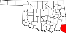
The town is located in southwest McCurtin County on US Route 70 3 miles (4.8 km) from the Choctaw - McCurtin county line. It is 6 miles (9.7 km) north of the Red River and the Oklahoma-Texas state line. Idabel is 15 miles (24 km) southeast on Route 70.[5]
According to the United States Census Bureau, the town has a total area of 0.8 square miles (2.1 km2), all of it land.
Demographics
| Historical population | |||
|---|---|---|---|
| Census | Pop. | %± | |
| 1910 | 656 | — | |
| 1920 | 809 | 23.3% | |
| 1930 | 608 | −24.8% | |
| 1940 | 551 | −9.4% | |
| 1950 | 661 | 20.0% | |
| 1960 | 477 | −27.8% | |
| 1970 | 840 | 76.1% | |
| 1980 | 927 | 10.4% | |
| 1990 | 873 | −5.8% | |
| 2000 | 769 | −11.9% | |
| 2010 | 754 | −2.0% | |
| Est. 2015 | 746 | [6] | −1.1% |
| U.S. Decennial Census[7] | |||
According to the census[2] of 2000, Valliant residents included 771 people, 315 households, and 194 families residing in the town. The population density was 1,023.8 people per square mile (396.9/km²). There were 351 housing units at an average density of 466.1 per square mile (180.7/km²). The racial makeup of the town was 75.49% White, 9.21% African American, 10.77% Native American, 0.52% from other races, and 4.02% from two or more races. Hispanic or Latino of any race were 0.91% of the population.
There were 315 households out of which 31.4% had children under the age of 18 living with them, 39.0% were married couples living together, 21.0% had a female householder with no husband present, and 38.4% were non-families. 35.2% of all households were made up of individuals and 18.1% had someone living alone who was 65 years of age or older. The average household size was 2.30 and the average family size was 3.00.
In the town, the population was spread out with 26.5% under the age of 18, 10.2% from 18 to 24, 23.2% from 25 to 44, 18.0% from 45 to 64, and 22.0% who were 65 years of age or older. The median age was 39 years. For every 100 females, there were 74.8 males. For every 100 females age 18 and over, there were 64.3 males.
The median income for a household in the town was $18,393, and the median income for a family was $26,058. Males had a median income of $24,125 versus $17,344 for females. The per capita income for the town was $10,380. About 24.3% of families and 31.7% of the population were below the poverty line, including 35.2% of those under age 18 and 28.2% of those age 65 or over.
Economy
The economic base of the town has been agriculture. Early-day crops were cotton and grains. Cotton began to decline after 1930, so the land was shifted into pasture and forage for feeding cattle. Forest products became important in the 1970s, when Weyerhaeuser Co., a paper products company opened a paperboard plant and a paper mill, making it the largest employer in town.[3][lower-alpha 1]
Notes
- ↑ Weyerhaeuser then had 350 production workers and 150 support workers before the company announcing that it would close one of its three paper machines indefinitely. It also sold its container board packaging and recycling business to International Paper. That included the Valiant mill.[8]
References
- 1 2
- 1 2 "American FactFinder". United States Census Bureau. Retrieved 2008-01-31.
- 1 2 3 Smith, Joy McDougal and Sharon McKeever. "Valiant." Encyclopedia of Oklahoma History and Culture. Accessed October 11, 2018.
- ↑ Chamber of Commerce of Valiant, Oklahoma. "History." Undated. Accessed October 11, 2018.
- ↑ Oklahoma Atlas & Gazeteer, DeLorme, 1st edition 1998, p. 66, ISBN 0-89933-283-8
- ↑ "Annual Estimates of the Resident Population for Incorporated Places: April 1, 2010 to July 1, 2015". Archived from the original on June 2, 2016. Retrieved July 2, 2016.
- ↑ "Census of Population and Housing". Census.gov. Retrieved June 4, 2015.
- ↑ Blossom, Debbie. "Why Valliant paper mill plant to shut unit, impacting 60 jobs." NewsOK. September 17, 2008. Accessed October 11, 2018.
