Kita-Matsumoto Station
Kita-Matsumoto Station 北松本駅 | |
|---|---|
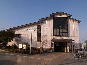 Kita-Matsumoto Station, October 2009 | |
| Location |
Shiraita 1-chome, Matsumoto-shi, Nagano-ken 390-0863 Japan |
| Elevation | 583.2 meters |
| Operated by |
|
| Line(s) | ■ Ōito Line |
| Distance | 0.7 km from Matsumoto |
| Platforms | 1 Island platform |
| Other information | |
| Station code | 41 |
| Website |
www |
| History | |
| Opened | 6 January 1915 |
| Previous names | Matsumoto Station (to April 1915) |
| Traffic | |
| Passengers (FY2015) | 756 |
| Location | |
 Kita-Matsumoto Station Location within Japan | |
Kita-Matsumoto Station (北松本駅 Kita-Matsumoto-eki) is a train station in the city of Matsumoto, Nagano Prefecture, Japan, operated by East Japan Railway Company (JR East).
Lines
Kita-Matsumoto Station is served by the Ōito Line and is 0.7 kilometers from the terminus of the line at Matsumoto Station.
Station layout
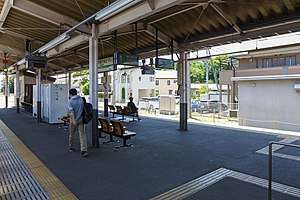
The station consists of one ground-level island platform, connected by an elevated station building. The station is a Kan'i itaku station.
Platforms
| 1 | ■ Ōito Line | for Matsumoto |
| 2 | ■ Ōito Line | for Shinano-Ōmachi, Hakuba and Minami-Otari |
Adjacent stations
| « | Service | » | ||
|---|---|---|---|---|
| Ōito Line | ||||
| Matsumoto (42) | - | Shimauchi (40) | ||
History
Kita-Matsumoto Station opened on 6 January 1915 as Matsumoto Station (松本駅) for both passenger and freight operations. Three months later, on 5 April 1915, a new Matsumoto Station was built, and the original station was renamed Kita-Matsumoto and used for freight operations only. Passenger operations resumed on 18 September 1916. With the privatization of Japanese National Railways (JNR) on 1 April 1987, the station came under the control of JR East. A new elevated station building was completed in April 2000.
Passenger statistics
In fiscal 2015, the station was used by an average of 756 passengers daily (boarding passengers only).[1]
Surrounding area
See also
References
- ↑ 各駅の乗車人員 (2015年度) [Station passenger figures (Fiscal 2015)] (in Japanese). Japan: East Japan Railway Company. 2016. Retrieved 5 July 2016.
External links
| Wikimedia Commons has media related to Kita-Matsumoto Station. |
- JR East station information (in Japanese)
Coordinates: 36°14′12″N 137°57′39″E / 36.2368°N 137.9608°E