Hakuba, Nagano
| Hakuba 白馬村 | |||
|---|---|---|---|
| Village | |||
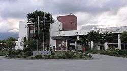 Hakuba Village Hall | |||
| |||
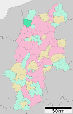 Location of Hakuba in Nagano Prefecture | |||
 Hakuba | |||
| Coordinates: 36°41′53″N 137°51′42.9″E / 36.69806°N 137.861917°ECoordinates: 36°41′53″N 137°51′42.9″E / 36.69806°N 137.861917°E | |||
| Country | Japan | ||
| Region | Chūbu (Kōshin'etsu) | ||
| Prefecture | Nagano | ||
| District | Kitaazumi | ||
| Area | |||
| • Total | 189.36 km2 (73.11 sq mi) | ||
| Population (October 2016) | |||
| • Total | 8,789 | ||
| • Density | 46.4/km2 (120/sq mi) | ||
| Time zone | UTC+9 (Japan Standard Time) | ||
| Symbols | |||
| • Tree | Prunus sargentii and Magnolia kobus | ||
| • Flower | Erythronium japonicum | ||
| Phone number | 0261-72-5000 | ||
| Address | 7025 Hokujo, Hakuba-mura, Kitaazumi-gun, Nagano-ken 399-9393 | ||
| Website | http://www.vill.hakuba.nagano.jp/ | ||

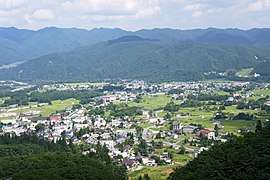
Hakuba (白馬村 Hakuba-mura) is a village located in Nagano Prefecture, Japan. As of 1 October 2016, the village had an estimated population of 8,789, and a population density of 46.4 persons per km². Its total area is 189.36 square kilometres (73.11 sq mi). Hakuba is an internationally renowned ski resort town in the northern Japan Alps. As the surrounding valley has an annual snow fall of over 11 meters, it is the central hub for 10 ski resorts with more than 200 runs. The village was the main event venue for 1998 Winter Olympics (Alpine, Ski Jump, Crosscountry).
Geography
Hakuba is located in the mountainous far northwestern Nagano Prefecture, bordered by Toyama Prefecture to the west. Much of the village is within the borders of the Chūbu-Sangaku National Park.
Surrounding municipalities
- Nagano Prefecture
- Niigata Prefecture
- Toyama Prefecture
Climate
Hakuba receives approximately 11 meters of snowfall annually, with most snowfall occurring in the months of January and February.[1]
Hakuba has a humid continental climate (Köppen Dfa), with cold, extremely snowy winters, and warm, rainy summers. With temperatures cooled by the elevation, monthly 24-hour average temperature ranges from −3.0 °C (26.6 °F) in January to 22.6 °C (72.7 °F) in July.
| Climate data for Hakuba Village | |||||||||||||
|---|---|---|---|---|---|---|---|---|---|---|---|---|---|
| Month | Jan | Feb | Mar | Apr | May | Jun | Jul | Aug | Sep | Oct | Nov | Dec | Year |
| Average high °C (°F) | 1.4 (34.5) |
2.2 (36) |
6.3 (43.3) |
14.5 (58.1) |
20.3 (68.5) |
23.4 (74.1) |
26.7 (80.1) |
28.6 (83.5) |
23.4 (74.1) |
17.5 (63.5) |
11.2 (52.2) |
4.8 (40.6) |
15.0 (59) |
| Daily mean °C (°F) | −3 (27) |
−2.6 (27.3) |
0.9 (33.6) |
7.6 (45.7) |
13.4 (56.1) |
17.5 (63.5) |
21.2 (70.2) |
22.6 (72.7) |
18.1 (64.6) |
11.4 (52.5) |
5.3 (41.5) |
−0.1 (31.8) |
9.4 (48.9) |
| Average low °C (°F) | −7.5 (18.5) |
−7.5 (18.5) |
−4 (25) |
1.7 (35.1) |
7.5 (45.5) |
12.9 (55.2) |
17.3 (63.1) |
18.4 (65.1) |
14.2 (57.6) |
6.8 (44.2) |
0.6 (33.1) |
−4.3 (24.3) |
4.7 (40.5) |
| Average precipitation mm (inches) | 144.9 (5.705) |
134.9 (5.311) |
143.5 (5.65) |
118.3 (4.657) |
144.6 (5.693) |
214.9 (8.461) |
289.4 (11.394) |
170.0 (6.693) |
184.3 (7.256) |
121.5 (4.783) |
109.8 (4.323) |
128.7 (5.067) |
1,904.7 (74.988) |
| Average snowfall cm (inches) | 220 (86.6) |
180 (70.9) |
111 (43.7) |
8 (3.1) |
0 (0) |
0 (0) |
0 (0) |
0 (0) |
0 (0) |
1 (0.4) |
21 (8.3) |
132 (52) |
668 (263) |
| Mean monthly sunshine hours | 79.7 | 102.1 | 142.0 | 178.1 | 178.4 | 137.7 | 138.0 | 165.1 | 113.7 | 127.0 | 110.8 | 84.6 | 1,554.9 |
| Source: 気象庁[2] | |||||||||||||
History
The area of present-day Hakuba was part of ancient Shinano Province and was part of the territory controlled by Matsumoto Domain under the Tokugawa shogunate of the Edo period. Hakuba was once part of the route called the Salt Road used to bring salt and other marine products from the coast at Itoigawa in Echigo Province (now Niigata Prefecture).[3]
The modern village of Hakuba was established on September 30, 1956 by the merger of the villages of Hokujo and Kamishiro.
Hakuba and surrounding municipalities were impacted by a reported 6.7 magnitude earthquake on 22 November 2014. The quake hit at 10:08pm at a depth of 5 km causing a number of residential properties to collapse and injuring at least 41 people.[4] Despite some localized road damage and a suspension of rail services on sections of the Ōito Line, there was however no major impact on hotels or ski tourism related infrastructure.[5][6]
Economy
The economy of Hakuba is heavily dependent on seasonal tourism.
Education
Hakuba has two public elementary schools and one public middle school operated by the village government. The village has one public high school operated by the Nagano Prefectural Board of Education.
Transportation
Railway
Highway
International relations


Local attractions
Surrounded by the Sea of Japan (northward), Nagano City (eastward) and the Tateyama Kurobe Dam area (southward), Hakuba is also a popular summer vacation area which offers a variety of outdoor activities at an altitude of 700–800 metres, e.g. hiking, rafting/shower climbing, paragliding, mountain bike, bird sighting etc. Other day activities to enjoy include visiting the snow monkeys, kimno experiences, Taiko drumming, traditional cooking classes, Matsuomoto castle tours and more. [8]
Ski resorts
The Hakuba Valley (which also includes the neighboring city of Omachi) is home to nine resorts, including 135 lifts (inc. 5 gondolas) accessing over 200 runs that offer an expanse of terrain and at least 14 terrain parks. There are 960 hectares of skiable terrain which equates to 137km of piste. The Hakuba ski resorts aren’t interconnected via the slopes (except for Hakuba 47 and Goryu, and Cortina and Norikura), but they can be accessed off a common lift ticket and there are free shuttle buses to get around to the different ski areas. The ski resorts from north to south are: Cortina, Norikura, Tsugaike Kogen, Iwatake, Happo-One, Hakuba 47, Goryu, Sanosaka (presently closed), Kashimayari, Jigatake, and Minekata is on the opposite side of the valley from the town of Hakuba.
Hakuba offers varied forms of skiing across the resorts but it’s generally very well suited to beginners and intermediates with many long perfectly groomed runs and fantastic fall-line. There's also some world class back country skiing on offer.[9]
Hakuba has lessons and guiding available through both traditional Japanese ski schools and International ski schools including: Evergreen International Ski School, Happo-one Ski and Snowboard School, Hakuba Snow Sports School and Hakuba 47 Ski Academy International. [10]
In popular culture
- The ski resorts and village of Hakuba were the setting for the 2008 Japanese film "Gin Iro No Shiizun" (銀色のシーズン).
- Hakuba is shown in episodes 21 and 22 of the anime Great Teacher Onizuka.
References
- ↑ Hakuba Guide. Hakuba Guide. Accessed October 15, 2017.
- ↑ "平年値(年・月ごとの値)". Kishōchō. Retrieved May 31, 2012.
- ↑ Hakuba Guide. Hakuba Guide. Accessed October 15, 2017.
- ↑ "Magnitude 6.7 quake injures at least 41 in Nagano". Japan Times. Kyodo, AP, Staff Report. 23 November 2014. Retrieved 25 November 2014.
- ↑ Nakamichi, Takashi (November 23, 2014). "Strong Earthquake Hits Central Japan, Destroying Buildings in Ski Town". The Wall Street Journal. Retrieved 25 November 2014.
- ↑ Kondo, Yukio. "Hakuba ski resorts quell rumors of quake damage". The Asahi Shimbun. Archived from the original on 27 November 2014. Retrieved 8 December 2014.
- 1 2 "International Exchange". List of Affiliation Partners within Prefectures. Council of Local Authorities for International Relations (CLAIR). Retrieved 21 November 2015.
- ↑ http://hakuba.com/plan-your-trip/day-trips-new/
- ↑ Hakuba Guide. Hakuba Guide. Accessed October 15, 2017.
- ↑ http://hakuba.com/plan-your-trip/lessons/
External links

| Wikivoyage has a travel guide for Hakuba. |
- Official Website (in Japanese)
- Hakuba Official Tourism Website (in English)
| Core city | |
|---|---|
| Special city | |
| Cities | |
| Districts | |