Ōtaki, Nagano
| Ōtaki 王滝村 | |||
|---|---|---|---|
| Village | |||
 Ōtaki Village Hall | |||
| |||
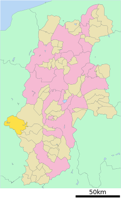 Location of Ōtaki in Nagano Prefecture | |||
 Ōtaki | |||
| Coordinates: 35°48′33.6″N 137°33′2.7″E / 35.809333°N 137.550750°ECoordinates: 35°48′33.6″N 137°33′2.7″E / 35.809333°N 137.550750°E | |||
| Country | Japan | ||
| Region | Chūbu (Kōshin'etsu) | ||
| Prefecture | Nagano | ||
| District | Kiso | ||
| Area | |||
| • Total | 310.82 km2 (120.01 sq mi) | ||
| Population (October 2016) | |||
| • Total | 829 | ||
| • Density | 2.67/km2 (6.9/sq mi) | ||
| Time zone | UTC+9 (Japan Standard Time) | ||
| Symbols | |||
| • Tree | Chamaecyparis obtusa | ||
| • Flower | Rhododendron subg. Hymenanthes | ||
| Phone number | 0264-48-2001 | ||
| Address | 3623 Kamijo, Ōtaki-mura, Kiso-gun, Nagano-ken 397-0201 | ||
| Website | http://www.vill.otaki.nagano.jp/ | ||


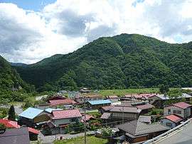
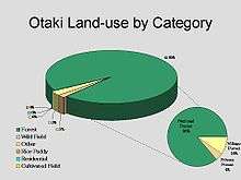
Ōtaki (王滝村 Ōtaki-mura) is a village located in Nagano Prefecture, Japan. As of 1 October 2016, the village had an estimated population of 829, and a population density of 2.67 persons per km². Its total area is 310.82 square kilometres (120.01 sq mi). At present, Ōtaki's land area is 95% forestland; 86% of which is designated national forest.
Geography
Ōtaki is located in the Kiso Mountains of southwest Nagano Prefecture, bordered by Gifu Prefecture to the west. Mount Ontake (3067 meters) is on the northern border of the village. Makio Dam is located within the village.
Surrounding municipalities
- Nagano Prefecture
- Gifu Prefecture
History
The area of present-day Ōtaki was part of ancient Shinano Province, and the name of Ōtaki appears in a 1504 record as part of the Chikuma region of Shinano. The modern village of Ōtaki was incorporated on April 1, 1889 by the establishment of the municipalities system.
In 1917, construction begins on the Ōtaki forest railroad (王滝 森林鉄道) The railroad was discontinued on June 30, 1975. On May 1, 1968, Chikuma District was renamed Kiso District. On September 14, 1984 the 1984 Otaki earthquake causesd section of Mount Ontake to crumble and flow into the Ōtaki Valley, with 29 people reported dead or missing and 87 homes destroyed.
Demographics
Demographically, Ōtaki is undergoing drastic changes. The population structure of Ōtaki is similar to that found in rural areas across Japan; a rising elderly population coupled with a decline in overall population. Ōtaki’s population currently stands at 995, down from 2,266 in 1970. During this same period the rate of elderly residents has risen to 32.4%. Though tourism remains the primary industry in Ōtaki, tourist numbers (including skiers and worshipers) have declined in recent years. After tourism, manufacturing jobs are the most prevalent, followed finally by agriculture. On the ground, this pattern takes the form of elderly residents engaging in agricultural work, while younger family members (if any remain in the village) work outside of the home.
Ōtaki is struggling economically, due in large part to public debt accrued through the building and management of Ontake 2240 ski hill. For 2008 roughly 3/4 of Ōtaki’s annual budget is slated for administrative and financial operations, with almost a quarter of this being used to pay back public debt. This leaves only a fraction of funds for use in providing basic services such as sanitation, health, and education. Major cuts have been made to the salaries of village employees and to money spent social, cultural, and educational activities.
Transportation
Railway
- The village does not have any passenger railway service.
Highway
- The village is not located on any national highway
External links

- Official Website (in Japanese)
| Core city | |
|---|---|
| Special city | |
| Cities | |
| Districts | |