Nagiso, Nagano
| Nagiso 南木曽町 | |||
|---|---|---|---|
| Town | |||
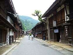 Tsumagoe-juku in Nagiso | |||
| |||
 Location of Nagiso in Nagano Prefecture | |||
 Nagiso | |||
| Coordinates: 35°36′13.2″N 137°36′31.8″E / 35.603667°N 137.608833°ECoordinates: 35°36′13.2″N 137°36′31.8″E / 35.603667°N 137.608833°E | |||
| Country | Japan | ||
| Region | Chūbu (Kōshin'etsu) | ||
| Prefecture | Nagano | ||
| District | Kiso | ||
| Area | |||
| • Total | 215.93 km2 (83.37 sq mi) | ||
| Population (October 2016) | |||
| • Total | 4,248 | ||
| • Density | 19.7/km2 (51/sq mi) | ||
| Time zone | UTC+9 (Japan Standard Time) | ||
| Symbols | |||
| • Tree | Chamaecyparis obtusa | ||
| • Flower | Rhododendron | ||
| Phone number | 0264-57-2001 | ||
| Address | 3668-1 Yomikaki, Nagiso-machi, Kiso-gun, Nagano-ken 399-5301 | ||
| Website | http://www.town.nagiso.nagano.jp/ | ||


Nagiso (箕輪町 Nagiso-machi) is a town located in Nagano Prefecture, Japan. As of 1 October 2016, the town had an estimated population of 4,248, and a population density of 19.7 persons per km². Its total area is 215.93 square kilometres (83.37 sq mi). Nagiso is listed as one of The Most Beautiful Villages in Japan.[1]
Geography
Nagiso is located in the Kiso Valley of southwestern Nagano Prefecture, bordered by Gifu Prefecture to the west.
Surrounding municipalities
- Nagano Prefecture
- Gifu Prefecture
History
The area of present-day Nagiso was part of ancient Shinano Province. During the Edo period, the area developed as series of post stations on the Nakasendō highway connecting Edo with Kyoto. The villages of Yomikaki, Tsumagoi and Tadachi merged to form the town of Nagiso on May 1, 1968.
Education
Nagiso has one public elementary schools and one public middle school operated by the town government, and one high school operated the Nagano Prefectural Board of Education.
Transportation
Railway
Highway
Local attractions
References
- ↑ The Most Beautiful Villages in Japan (in Japanese)
External links

- Official Website (in Japanese)
| Core city | |
|---|---|
| Special city | |
| Cities | |
| Districts | |