Kiso, Nagano (town)
| Kiso 木曽町 | |||
|---|---|---|---|
| Town | |||
 Kiso Town Hall | |||
| |||
 Location of Kiso Town in Nagano Prefecture | |||
 Kiso | |||
| Coordinates: 35°50′33.1″N 137°41′29.6″E / 35.842528°N 137.691556°ECoordinates: 35°50′33.1″N 137°41′29.6″E / 35.842528°N 137.691556°E | |||
| Country | Japan | ||
| Region | Chūbu (Kōshin'etsu) | ||
| Prefecture | Nagano | ||
| District | Kiso | ||
| Area | |||
| • Total | 476.03 km2 (183.80 sq mi) | ||
| Population (October 2016) | |||
| • Total | 11,561 | ||
| • Density | 24.3/km2 (63/sq mi) | ||
| Time zone | UTC+9 (Japan Standard Time) | ||
| Symbols | |||
| Phone number | 0264-22-3000 | ||
| Address | 2326-1 Fukushima, Kiso-machi, Kiso-gun, Nagano-ken 397-8588 | ||
| Website | https://www.town-kiso.com/ | ||


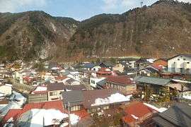
Kiso (木曽町 Kiso-machi) is a town located in Nagano Prefecture, Japan. As of 1 October 2016, the town had an estimated population of 11,561, and a population density of 24.3 persons per km². Its total area is 476.03 square kilometres (183.80 sq mi). Kiso Town is listed as one of The Most Beautiful Villages in Japan.[1]
Geography
Kiso is located in mountainous southwest Nagano Prefecture, bordered by Gifu Prefecture to the west.
Surrounding municipalities
- Nagano Prefecture
- Gifu Prefecture
Climate
| Climate data for Kiso-Fukushima | |||||||||||||
|---|---|---|---|---|---|---|---|---|---|---|---|---|---|
| Month | Jan | Feb | Mar | Apr | May | Jun | Jul | Aug | Sep | Oct | Nov | Dec | Year |
| Average high °C (°F) | 4.1 (39.4) |
5.4 (41.7) |
9.7 (49.5) |
16.6 (61.9) |
21.4 (70.5) |
24.4 (75.9) |
27.5 (81.5) |
29.2 (84.6) |
25.1 (77.2) |
19.4 (66.9) |
13.4 (56.1) |
7.4 (45.3) |
17 (62.5) |
| Average low °C (°F) | −7.0 (19.4) |
−6.5 (20.3) |
−2.7 (27.1) |
2.5 (36.5) |
7.9 (46.2) |
13.4 (56.1) |
17.6 (63.7) |
18.4 (65.1) |
14.5 (58.1) |
7.3 (45.1) |
0.9 (33.6) |
−4.0 (24.8) |
5.2 (41.3) |
| Average precipitation mm (inches) | 68.1 (2.681) |
86.2 (3.394) |
155.8 (6.134) |
149.1 (5.87) |
193.2 (7.606) |
236.3 (9.303) |
282.0 (11.102) |
167.0 (6.575) |
248.4 (9.78) |
146.1 (5.752) |
111.9 (4.406) |
62.9 (2.476) |
1,907 (75.079) |
| Average precipitation days (≥ 1.0 mm) | 7.8 | 7.7 | 11.6 | 11.7 | 11.9 | 13.8 | 15.4 | 11.1 | 12.9 | 10.2 | 9.0 | 8.2 | 131.3 |
| Mean monthly sunshine hours | 126.8 | 138.5 | 162.6 | 177.5 | 179.4 | 140.1 | 148.6 | 178.9 | 132.7 | 136.4 | 128.0 | 128.1 | 1,777.6 |
| Source: Japan Meteorological Agency | |||||||||||||
History
The area of present-day Kiso was part of ancient Shinano Province.
The modern town was created through a merger of the town of Kiso-Fukushima with the villages of Hiyoshi, Kaida and Mitake on November 1, 2005.
Education
Kiso has four public elementary schools and two public middle schools operated by the town government, and one high school operated the Nagano Prefectural Board of Education.
Transportation
Railway
Highway
Local attractions
References
- ↑ The Most Beautiful Villages in Japan (in Japanese)
External links

- Official Website (in Japanese)
| Core city | |
|---|---|
| Special city | |
| Cities | |
| Districts | |