Karuizawa, Nagano
| Karuizawa 軽井沢町 | |||
|---|---|---|---|
| Town | |||
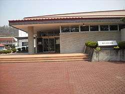 Karuizawa Town Hall | |||
| |||
 Location of Karuizawa in Nagano Prefecture | |||
 Karuizawa | |||
| Coordinates: 36°20′54.5″N 138°35′49.3″E / 36.348472°N 138.597028°ECoordinates: 36°20′54.5″N 138°35′49.3″E / 36.348472°N 138.597028°E | |||
| Country | Japan | ||
| Region | Chūbu (Kōshin'etsu) | ||
| Prefecture | Nagano | ||
| District | Kitasaku | ||
| Area | |||
| • Total | 156.03 km2 (60.24 sq mi) | ||
| Population (October 2016) | |||
| • Total | 19,939 | ||
| • Density | 128/km2 (330/sq mi) | ||
| Time zone | UTC+9 (Japan Standard Time) | ||
| Symbols | |||
| • Tree | Magnolia kobus | ||
| • Flower | Sakurasō (Primula sieboldii) | ||
| • Bird | Brown-headed thrush | ||
| Phone number | 0267-45-8111 | ||
| Address | 2381-1 Nagakura, Karuizawa-machi, Kitasaku-gun, Nagano-ken 389-0192 | ||
| Website | http://www.town.karuizawa.lg.jp/ | ||


Karuizawa (軽井沢町 Karuizawa-machi) is a town located in Nagano Prefecture, Japan. As of 1 October 2016, the town had an estimated population of 19,939, and a population density of 128 persons per km². Its total area is 156.03 square kilometres (60.24 sq mi). Karuizawa is a popular summer resort area for the residents of Tokyo.
Geography
Karuizawa is located in eastern Nagano Prefecture, bordered by Gunma Prefecture to the north, east and south. The town is located on an elevated plain at the foot of Mount Asama, one of Japan's most active volcanoes. The mountain is classed as a Category A active volcano. A small eruption was detected in June 2015, a more significant eruption spewing hot rocks and a plume of ash occurred in February 2015. Mt. Asama's most destructive eruption in recent recorded history took place in 1783, when over 1,000 were killed. The volcano is actively monitored by scientists and climbing close to the summit is prohibited.[1]
- Usui Pass
- Highest elevation: 2,568 metres (8,425 ft) (Top of Mount Asama)
- Lowest elevation: 798.7 metres (2,620.4 ft)
Surrounding municipalities
- Nagano Prefecture
- Gunma Prefecture
Climate
Karuizawa has a humid continental climate (Köppen climate classification Dfb) with warm summers and cold winters. Precipitation is much heavier in the summer than in the winter.
| Climate data for Karuizawa | |||||||||||||
|---|---|---|---|---|---|---|---|---|---|---|---|---|---|
| Month | Jan | Feb | Mar | Apr | May | Jun | Jul | Aug | Sep | Oct | Nov | Dec | Year |
| Average high °C (°F) | 1.9 (35.4) |
2.3 (36.1) |
6.1 (43) |
13.2 (55.8) |
18.2 (64.8) |
20.6 (69.1) |
24.0 (75.2) |
25.5 (77.9) |
20.5 (68.9) |
15.2 (59.4) |
10.5 (50.9) |
4.8 (40.6) |
13.6 (56.4) |
| Daily mean °C (°F) | −3.9 (25) |
−3.6 (25.5) |
−0.4 (31.3) |
6.3 (43.3) |
11.5 (52.7) |
15.3 (59.5) |
19.0 (66.2) |
20.2 (68.4) |
15.7 (60.3) |
9.2 (48.6) |
4.1 (39.4) |
−1.1 (30) |
7.7 (45.9) |
| Average low °C (°F) | −9.5 (14.9) |
−9.0 (15.8) |
−6.0 (21.2) |
−0.1 (31.8) |
5.0 (41) |
10.9 (51.6) |
15.3 (59.5) |
16.2 (61.2) |
12.2 (54) |
4.4 (39.9) |
−1.2 (29.8) |
−6.4 (20.5) |
2.7 (36.8) |
| Average precipitation mm (inches) | 29.9 (1.177) |
43.0 (1.693) |
59.6 (2.346) |
84.2 (3.315) |
108.8 (4.283) |
187.4 (7.378) |
184.1 (7.248) |
159.3 (6.272) |
173.3 (6.823) |
107.7 (4.24) |
50.7 (1.996) |
23.3 (0.917) |
1,211.3 (47.688) |
| Average snowfall cm (inches) | 29 (11.4) |
43 (16.9) |
37 (14.6) |
8 (3.1) |
0 (0) |
0 (0) |
0 (0) |
0 (0) |
0 (0) |
1 (0.4) |
3 (1.2) |
16 (6.3) |
137 (53.9) |
| Average relative humidity (%) | 74 | 75 | 73 | 72 | 74 | 84 | 87 | 86 | 88 | 83 | 77 | 74 | 79 |
| Mean monthly sunshine hours | 169.6 | 156.3 | 183.0 | 175.1 | 191.4 | 126.4 | 126.5 | 158.0 | 107.7 | 134.9 | 149.6 | 165.2 | 1,843.7 |
| Source: NOAA (1961–1990)[2] | |||||||||||||
History
The area of present-day Karuizawa was part of ancient Shinano Province, and developed as Karuizawa-shuku, a post station on the Nakasendō highway connecting Edo with Kyoto during the Edo period.
- August 2, 1876: The villages of Kutsukake, Shiozawanitta, Karijuku, Narusawanitta, and Yui merged to form the village of Nagakura. The village of Hatsuji in Saku District absorbed the village of Matorikaya.
- January 14, 1879: Kitasaku District Government enforced, and the town of Usuitoge, and the villages of Karuizawa, Nagakura, Oiwake belongs to Kitasaku District.
- 1886: Canadian Anglican missionary Rev. Alexander Croft Shaw and Tokyo Imperial University English professor James Main Dixon introduced Karuizawa as a summer resort.
- April 1, 1889: With the establishment of the municipalities system, the town of Usuitoge, and the villages of Karuizawa, and the areas of the former villages of Kutsukake, Shiozawanitta, and Karijuku from the village of Nagakura merged to form the village of Higashinagakura in Kitasaku District, and the areas of the former villages of Narusawanitta and Yui in the village of Nagakura, and the villages of Hatsuji and Oiwake merged to form the village of Nishinagakura in Kitasaku District.
- 1910s: Begins to attract the attention of other expatriates and Japanese.[3] Specially Germans congregate here, language professors and academics hold annual conferences.
- August 1, 1923: The village of Higashinagakura gains town status to become the town of Karuizawa. (The pre-town areas before gaining the town status is known as Kyu-Karuizawa.)
- May 8, 1942: The village of Nishinagakura is merged into Karuizawa
- 1942-45: Site of an internment camp for enemy foreigners and diplomats during World War 2.
- From 1943 relocation of an increasing number of Germans from Tokyo, which is suffering from US fire bombing. The Supreme Commander for the Allied Powers deported most of them in late 1947.
- 1951: Selected as International Cultural and Tourism City.
- February 1, 1957: Karuizawa absorbed Serizawa area from the former village of Goga, which was absorbed by the town of Miyota.
- April 1, 1959: The Kajikazawa area of the former village of Oiwake was split off and merged with the town of Miyota.
- 1964: 1964 Summer Olympics (Equestrian)
- February 1972: Asama-Sanso incident Police besiege communist militants holed up in holiday resort after mass killing and hostage taking.
- October 1, 1997: The Nagano Shinkansen opens, serving Karuizawa.
- 1998: 1998 Winter Olympics (Curling)
- 2004: Mount Asama erupts.
Economy
Hoshino Resorts has its headquarters in Karuizawa.[4]
Education
Karuizawa has three public elementary school and one public middle school operated by the town government, and one high school operated the Nagano Prefectural Board of Education. The UWC ISAK Japan international school is also located in the town.
Transportation
Railway
Highway
International relations

Local attractions
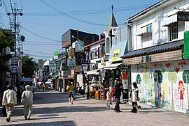
At an elevation of 1,000 m (3,281 ft) and a temperate summer climate, Karuizawa is a popular year round resort offering many outdoor sport, hot spring and recreational activities. Convenient road and rail access from central Tokyo, has ensured Karuizawa's popularity as a location for second homes and resort hotels since the Meiji era. The town is known for its historic shopping street known as "Ginza dōri" or "Kyū-dō" (Ginza Street, or the Old Road) and association with both Japanese royalty and visitors such as John Lennon and Yoko Ono.[6] Karuizawa hosted equestrian events in the 1964 Summer Olympics as well as curling in the 1998 Winter Olympics. To date, it is the only city in the world to have hosted both Summer and Winter Olympic events.
Since 1997, Karuizawa has been accessible via the JR East Nagano Shinkansen. New high speed rail links has resulted in modest population growth and the development of large outlet style shopping malls.
Notable residents
- Arishima Takeo, writer
- Endo Shusaku, novelist
- Idei Nobuyuki, former Sony Chairman, CEO
- Paul Jacoulet, woodblock print artist
- E. Herbert Norman, Canadian diplomat and historian
- Yoko Ono, artist, musician, and activist
- Alexander Croft Shaw, Anglican missionary
- Tabaimo, artist
References
- ↑ Demetriou, Danielle (16 June 2015). "Mount Asama volcano erupts near Tokyo". The Telegraph.
- ↑ "Karuizawa Climate Normals 1961-1990". National Oceanic and Atmospheric Administration. Retrieved December 31, 2012.
- ↑ Tohoku: The Scotland of Japan, p. 181
- ↑ "Company Overview of Hoshino Resort Co., Ltd. (Archive). Bloomberg Businessweek. Retrieved on September 22, 2013. "2148, oazanagakura karuizawa-machi Kitasaku, 389-0111 Japan"
- 1 2 "International Exchange". List of Affiliation Partners within Prefectures. Council of Local Authorities for International Relations (CLAIR). Retrieved 21 November 2015.
- ↑ Davis, Tony (8 May 2015). "Nakasendo walking trail leads to the heart of old Japan – and bear country". The Australian Financial Review.
External links

- Official Website (in Japanese)
- Karuizawa Tourism Website (in Japanese)
- Karuizawa Tourism Website (in English)
| Authority control |
|---|
| Core city | |
|---|---|
| Special city | |
| Cities | |
| Districts | |