Nakagawa, Nagano
| Nakagawa 中川村 | |||
|---|---|---|---|
| Village | |||
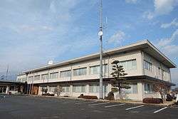 Nakagawa Village Hall | |||
| |||
 Location of Nakagawa in Nagano Prefecture | |||
 Nakagawa | |||
| Coordinates: 35°38′4.3″N 137°56′45.5″E / 35.634528°N 137.945972°ECoordinates: 35°38′4.3″N 137°56′45.5″E / 35.634528°N 137.945972°E | |||
| Country | Japan | ||
| Region | Chūbu (Kōshin'etsu) | ||
| Prefecture | Nagano | ||
| District | Kamiina | ||
| Area | |||
| • Total | 77.05 km2 (29.75 sq mi) | ||
| Population (October 2016) | |||
| • Total | 4,810 | ||
| • Density | 62.4/km2 (162/sq mi) | ||
| Time zone | UTC+9 (Japan Standard Time) | ||
| Symbols | |||
| • Tree | Chamaecyparis obtusa | ||
| • Flower | Ponerorchis | ||
| Phone number | 0265-88-3001 | ||
| Address | 4045-1 Okusa, Nakagawa-mura, Kamiina-gun, Nagano-ken 399-3892 | ||
| Website | http://www.vill.nakagawa.nagano.jp/ | ||


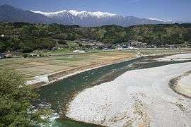
Nakagawa village from Makigahara Bridge
Nakagawa (中川村 Nakagawa-mura) is a village located in Nagano Prefecture, Japan. As of 1 October 2016, the village had an estimated population of 4,810, and a population density of 62.4 persons per km². Its total area is 77.05 square kilometres (29.75 sq mi). Nakagawa is listed as one of The Most Beautiful Villages in Japan.[1]
Geography
Nakagawa is located in the Ina Valley of south-central Nagano Prefecture in the Kiso Mountains. The Tenryū River flows through the village. The Koshibu Dam is located in Nakagawa.
Surrounding municipalities
History
The area of present-day Nakagawa was part of ancient Shinano Province. The villages of Katagiri and Minakata merged on August 1, 1959 to form the village of Nakagawa.
Transportation
Railway
Highway
Notable people from Nakagawa
- Kōichi Shiozawa, Admiral in the Imperial Japanese Navy
References
- ↑ The Most Beautiful Villages in Japan (in Japanese)
External links

- Official Website (in Japanese)
| Core city | |
|---|---|
| Special city | |
| Cities | |
| Districts | |
This article is issued from
Wikipedia.
The text is licensed under Creative Commons - Attribution - Sharealike.
Additional terms may apply for the media files.