Ōshika, Nagano
| Ōshika 大鹿村 | |||
|---|---|---|---|
| Village | |||
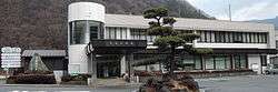 Ōshika Village Hall | |||
| |||
 Location of Ōshika in Nagano Prefecture | |||
 Ōshika | |||
| Coordinates: 35°34′41.5″N 138°2′2.4″E / 35.578194°N 138.034000°ECoordinates: 35°34′41.5″N 138°2′2.4″E / 35.578194°N 138.034000°E | |||
| Country | Japan | ||
| Region | Chūbu (Kōshin'etsu) | ||
| Prefecture | Nagano | ||
| District | Shimoina | ||
| Area | |||
| • Total | 248.28 km2 (95.86 sq mi) | ||
| Population (October 2016) | |||
| • Total | 1,019 | ||
| • Density | 4.1/km2 (11/sq mi) | ||
| Time zone | UTC+9 (Japan Standard Time) | ||
| Symbols | |||
| • Tree | Betula platyphylla | ||
| • Flower | Fritillaria camschatcensis | ||
| Phone number | 0265-39-2001 | ||
| Address | 354 Okawara, Ōshika-mura, Shimoina-gun, Nagano-ken 399-3502 | ||
| Website | http://www.vill.ooshika.nagano.jp/ | ||


Panorama of Ōshika Village
Ōshika (大鹿村 Ōshika-mura) is a village located in Nagano Prefecture, Japan. As of 1 October 2016, the village had an estimated population of 1,019, and a population density of 4.1 persons per km². Its total area is 248.28 square kilometres (95.86 sq mi).
Geography
Ōshika is located mountainous southern of Nagano Prefecture, between the Ina Mountains and the Akaishi Mountains.
Surrounding municipalities
History
The area of present-day Ōshika was part of ancient Shinano Province. The village of Ōshika was established on April 1, 1889 with the establishment of the municipalities system.
Education
Ōshika has one public elementary school and one public middle school operated by the village government. The village does not have a high school.
Transportation
Railway
- The village does not have any passenger railway service
Highway
External links

- Official Website (in Japanese)
| Core city | |
|---|---|
| Special city | |
| Cities | |
| Districts | |
This article is issued from
Wikipedia.
The text is licensed under Creative Commons - Attribution - Sharealike.
Additional terms may apply for the media files.