Nyoma
| Nyoma Nyama, Neoma | |
|---|---|
| village | |
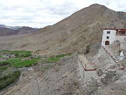 Nyoma's setting as seen from the gompa (Buddhist monastery) | |
 Nyoma Location in Jammu and Kashmir, India  Nyoma Nyoma (India) | |
| Coordinates: 33°12′21″N 78°38′54″E / 33.2059163°N 78.6483843°ECoordinates: 33°12′21″N 78°38′54″E / 33.2059163°N 78.6483843°E | |
| Country | India |
| State | Jammu and Kashmir |
| District | Leh |
| Tehsil | Leh |
| Elevation | 4,180 m (13,710 ft) |
| Population (2011) | |
| • Total | 918 |
| Time zone | UTC+5:30 (IST) |
| PIN | 194404 |
| 2011 census code | 901 |

Nyoma is a village in the Leh district of Jammu and Kashmir, India.[1] It is located in the Leh tehsil, on the bank of Indus River.
A small Buddhist monastery ("gompa") is located on the hill at the back of the village. Since 2010, foreign tourists with Inner Line Permits are permitted to visit Nyoma and its monastery.
Nyoma is also home to an Advanced Landing Ground of Indian Airforce, which is proposed to be reactivated. An AN32 landed in this airfield after which it was opened on 18 September 2009.[2][3]
Nearby towns are Mahe and Rupshu, the town lies in the Leh - Loma - Hanle road. Nyoma is located 41 km southeast of Chumathang.[4] It is 23 km (14 miles) from Mahe village and roughly the same distance from the Chinese border.[5]
Demographics
According to the 2011 census of India, Nyoma has 202 households. The effective literacy rate (i.e. the literacy rate of population excluding children aged 6 and below) is 49.94%.[6]
| Total | Male | Female | |
|---|---|---|---|
| Population | 918 | 427 | 491 |
| Children aged below 6 years | 125 | 63 | 62 |
| Scheduled caste | 2 | 0 | 2 |
| Scheduled tribe | 707 | 329 | 378 |
| Literates | 396 | 198 | 198 |
| Workers (all) | 345 | 212 | 133 |
| Main workers (total) | 160 | 100 | 60 |
| Main workers: Cultivators | 40 | 28 | 12 |
| Main workers: Agricultural labourers | 6 | 1 | 5 |
| Main workers: Household industry workers | 5 | 4 | 1 |
| Main workers: Other | 109 | 67 | 42 |
| Marginal workers (total) | 185 | 112 | 73 |
| Marginal workers: Cultivators | 13 | 9 | 4 |
| Marginal workers: Agricultural labourers | 119 | 68 | 51 |
| Marginal workers: Household industry workers | 4 | 0 | 4 |
| Marginal workers: Others | 49 | 35 | 14 |
| Non-workers | 573 | 215 | 358 |
References
- ↑ "Blockwise Village Amenity Directory" (PDF). Ladakh Autonomous Hill Development Council. Retrieved 2015-07-23.
- ↑
- ↑
- ↑
- ↑ Ladakh, The Essential Guide with Kashmir and Kulu-Manali. Second Edition 2010. Partha S. Banarjee. Milestone Books, Calcutta, p. 183
- 1 2 "Leh district census". 2011 Census of India. Directorate of Census Operations. Retrieved 2015-07-23.
| Western Air Command |  | |
|---|---|---|
| Eastern Air Command | ||
| Central Air Command | ||
| Southern Air Command | ||
| South Western Air Command | ||
| Training Command | ||
| Maintenance Command | ||
| Advanced Landing Grounds (ALGs) | ||
All bases and landing grounds are suffixed with AFS and ALG which means Air Force Station and Advanced Landing Ground respectively. Examples: Pathankot AFS, Fukche ALG | ||