Shopian
| Shopian | |
|---|---|
| town | |
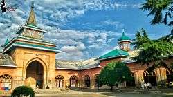 Historic Jamia Masjid Shopian | |
| Country | India |
| State | Jammu and Kashmir |
| District | Shopian |
| Area | |
| • Total | 612.87 km2 (236.63 sq mi) |
| Elevation | 2,057 m (6,749 ft) |
| Population (2001) | |
| • Total | 211,000 |
| • Density | 340/km2 (890/sq mi) |
| Languages | |
| • Official | Urdu |
| Time zone | UTC+5:30 (IST) |
| PIN | 192303 |
| Sex ratio | 950:1000 ♂/♀ |
Shopian or Shupiyan is a town in Kashmir. It is the administrative headquarters of the Shopian district.
General
The geologist Frederic Drew stated that Shopian derived its name from a distortion of word shah-payan, i.e. "royal stay". However, the local people hold the view that Shopian was earlier named as "Shin-Van" meaning "snow forest". The Shias have a different view, believing it was earlier inhabited by Shias so it is "Shin-Van" that is "The Forest of Shias". Shopian is an ancient town of Kashmir and had an importance due to it being situated on the ancient imperial route, commonly known as Mughal Road, which connects Lahore and Srinagar.[1] Shopian was one out of six Wazarat Headquarters in Kashmir from 1872-1892 A.D.
Shopian town is 51 kilometres (32 mi) from Srinagar and 20 kilometres (12 mi) from Pulwama at an elevation of 2,146 metres (7,041 ft) above sea level. It has decades-old road connectivity with Anantnag as well as Kulgam.
Geography
Shupiyan is located at 33°43′N 74°50′E / 33.72°N 74.83°E.[2] It has an average elevation of 2057 metres (6748 feet). It is 54 km from Srinagar.
Demographics
As of 2001 India census,[3] Shupiyan Town had a population of 12,396. Males constitute 51% of the population and females 49%. Shupiyan has an average literacy rate of 59%, lower than the national average of 59.5%: male literacy is 67%, and female literacy is 51%. In Shupiyan, 11% of the population is under 6 years of age.
Notable people
References
- ↑ Bloeria, Sudhir S. (2000). Pakistan's Insurgency vs India's Security: Tackling Militancy in Kashmir. New Delhi: Manas Publications. p. 172. ISBN 978-81-7049-116-3.
- ↑ Falling Rain Genomics, Inc - Shupiyan
- ↑ "Census of India 2001: Data from the 2001 Census, including cities, villages and towns (Provisional)". Census Commission of India. Archived from the original on 2004-06-16. Retrieved 2008-11-01.
External links
Places adjacent to Shopian | ||||||||||
|---|---|---|---|---|---|---|---|---|---|---|
| ||||||||||