Aizawl
| Aizawl | |
|---|---|
| Capital | |
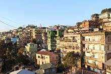
 Montage of Aizawl City Clockwise from top left: Pachhunga University Entrance gate, Solomon's Temple in Aizawl, Aizawl Bazar, Night View of Aizawl, Lengpui Airport Building | |
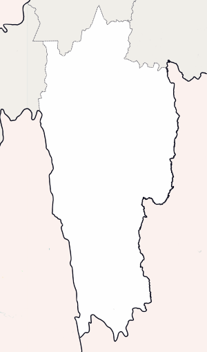 Aizawl Location of Aizawl in India  Aizawl Aizawl (India) | |
| Coordinates: 23°43′38″N 92°43′04″E / 23.72722°N 92.71778°ECoordinates: 23°43′38″N 92°43′04″E / 23.72722°N 92.71778°E | |
| Country |
|
| State | Mizoram |
| District | Aizawl |
| Area | |
| • Total | 457 km2 (176 sq mi) |
| Elevation | 1,132 m (3,714 ft) |
| Population (2011) | |
| • Total | 293,416[1] |
| • Density | 234/km2 (610/sq mi) |
| Languages | |
| • Official | Mizo |
| Time zone | UTC+5:30 (IST) |
| PIN | 796001 |
| Telephone code | 0389 |
| Vehicle registration | MZ-01 |
| Sex ratio | 1025 females per 1000 males ♂/♀[1] |
| Climate | Cwa |
| Literacy | 98.36%[1] |
Aizawl (English: /aɪˈzɔːl/;[2] Mizo: [ˈʌɪ̯.ˈzɔːl] (![]()
History
In 1871-72, the disorderly conduct of Khalkom, a Mizo chief, compelled the British to establish an outpost that later became the Aizawl village.[5] In 1890, officer Dally of the Assam Police and his 400 men arrived at Aizawl to support Colonel Skinner's troops during a British military operation against the Mizo tribals. On Dally's recommendation, Aizawl was selected as the site of a fortified post that Colonel Skinner had been ordered to construct. The troops constructed stockades and buildings at the site.[6] In 1892-95 Aizawl became accessible from Silchar by fair weather road under the supervision of Major Loch. The Indian Air Force carried out air strikes on the town during the March 1966 Mizo National Front uprising, following which the MNF withdrew to Lunglei.[7] Until 1966, Aizawl was a large village but the regrouping of Mizo villages after the uprising made it become a larger town and then a city. Aizawl has become the centre of Road network in Mizoram connecting the north and south, east and west. More than 25% of the Mizoram population reside in Aizawl.
Geography
Aizawl is located north of the Tropic of Cancer in the northern part of Mizoram. It is situated on a ridge 1,132 metres (3715 ft) above sea level, with the Tlawng river valley to its west and the Tuirial river valley to its east.
Climate
| Aizawl | ||||||||||||||||||||||||||||||||||||||||||||||||||||||||||||
|---|---|---|---|---|---|---|---|---|---|---|---|---|---|---|---|---|---|---|---|---|---|---|---|---|---|---|---|---|---|---|---|---|---|---|---|---|---|---|---|---|---|---|---|---|---|---|---|---|---|---|---|---|---|---|---|---|---|---|---|---|
| Climate chart (explanation) | ||||||||||||||||||||||||||||||||||||||||||||||||||||||||||||
| ||||||||||||||||||||||||||||||||||||||||||||||||||||||||||||
| ||||||||||||||||||||||||||||||||||||||||||||||||||||||||||||
Aizawl has a mild, sub-tropical climate due to its location and elevation. Under the Köppen climate classification, Aizawl features a humid subtropical climate (Cwa) but very rainy. In the summer the temperature ranges from 20–30 °C (68–86 °F), and in the winter 11–21 °C (52–70 °F).[8]
| Climate data for Aizawl | |||||||||||||
|---|---|---|---|---|---|---|---|---|---|---|---|---|---|
| Month | Jan | Feb | Mar | Apr | May | Jun | Jul | Aug | Sep | Oct | Nov | Dec | Year |
| Average high °C (°F) | 20.4 (68.7) |
21.7 (71.1) |
25.2 (77.4) |
26.8 (80.2) |
26.3 (79.3) |
25.5 (77.9) |
25.3 (77.5) |
25.5 (77.9) |
25.7 (78.3) |
24.7 (76.5) |
23.0 (73.4) |
21.0 (69.8) |
24.3 (75.7) |
| Average low °C (°F) | 11.4 (52.5) |
12.8 (55) |
15.6 (60.1) |
17.5 (63.5) |
18.1 (64.6) |
18.9 (66) |
19.1 (66.4) |
19.1 (66.4) |
19.2 (66.6) |
18.0 (64.4) |
15.1 (59.2) |
12.2 (54) |
16.4 (61.5) |
| Average precipitation mm (inches) | 13.4 (0.528) |
23.4 (0.921) |
73.4 (2.89) |
167.7 (6.602) |
289.0 (11.378) |
406.1 (15.988) |
320.4 (12.614) |
320.6 (12.622) |
305.2 (12.016) |
183.7 (7.232) |
43.2 (1.701) |
15.3 (0.602) |
2,161.4 (85.094) |
| Average precipitation days | 0.5 | 2.1 | 5.0 | 8.4 | 12.8 | 19.4 | 19.3 | 19.6 | 17.2 | 10.6 | 1.8 | 0.4 | 117.1 |
| Source: World Meteorological Organization[9] | |||||||||||||
Cityscape

Civic Administration
The Aizawl Municipal Council is the authority of civic administration of Aizawl city. It was formed in 2010 with 19 Members when the Congress-ZNP party coalition was voted to power in the state legislative assembly. The AMC office is being administered by one council Chairman, Vice-Chairman and three executive members.[10] It consists of 19 elected members representing 19 wards of the city and others appointed by the Governor of Mizoram. One-third of the total membership is reserved for women, these six seats shall be rotated after every five years. The tenure of the council is five years. There is a Ward Committee in every ward that consists of a Chairman, who is an elected councillor from that ward, and two members each from all the local council within the ward. There are 78 local councils having a term of 5 years.[11]
Demographics
As of 2011 India census,[12] Aizawl had a population of 293,416. Females constitute 50.61% of the population and males made up the remaining 49.39%. Mizos from various tribes make up the majority of the population. Christianity forms majority of the city population about 93.63%.[1] Other minority religions are Hinduism 4.14, Islam 1.52, Buddhism 0.45, Others 0.09%, Sikhism 0.03% and Jainism 0.02%.[1] 0.11% peoples did not state their religion.[1]
Presbyterians make up the majority of the population. However, there are also significant numbers of the Salvation Army, Baptists, Seventh-day Adventists, United Pentecostal Church and Roman Catholics in the city. There are also some cultural based Christian sects. Hinduism and Islam are also represented in very small numbers in the city population.
Economy
The economy of Aizawl is basically sustained by government services as it is capital of Mizoram. The major banks are also located within Aizawl. A 3-star category hotel, Hotel Regency, has recently been inaugurated at Zarkawt, a central location within the city. It provides a much-needed hospitality service for tourists and business visitors to Aizawl. There are several other hotels apart from Hotel Regency. Those include - Hotel Sangchia located in Zarkawt, Hotel Grand located in Zarkawt, Hotel Floria located in Dawrpui, Ritz Hotel located in Canteen Kual, Tourist Lodge located in Chaltlang, Chawlhna Hotel located in Zarkawt, Riakmaw Inn located in Zarkawt, Hotel Ahimsa located in Zarkawt, and other numerous affordable hotels.
Inner Line Permit (ILP)
Domestic tourists require the Inner Line Permit (ILP) for entry into Mizoram, for persons other than Government employees. ILP can be obtained from the Liaison Officers in New Delhi, Kolkata, Mumbai, Guwahati, Shillong, and Silchar. It can also be obtained on arrival at the Lengpui Airport (nearest airport to Aizawl).[13]
Foreign nationals have to register themselves at the office of the Superintendent of the Police (CID/SB) of Mizoram within 24hours of arrival. However, citizens of China, Afghanistan, Bangladesh and Pakistan require prior approval of the Ministry of Home Affairs before entering the state.[13]
Transport
Air
Aizawl is connected by air transport through Lengpui Airport which it is situated near Aizawl. The airport provides connectivity to Kolkata Netaji Subhash Chandra Bose International Airport, Guwahati Lokpriya Gopinath Bordoloi International Airport, Shillong Airport and Imphal Imphal International Airport. Air India, Jet Airways are the three regular airlines which operate flights to and from Lengpui Airport. A helicopter service by Pawan Hans[14] was started in 2012 and connects the city with Lunglei, Lawngtlai, Saiha, Chawngte, Serchhip, Champhai, Kolasib, Khawzawl, Ngopa and Hnahthial.[15][16]
Rail
Mizoram is connected by railroad up to Bairabi, there are plans to connect Bairabi with Sairang with broad gauge railway track, near Aizawl. The government has also started a broad gauge Bairabi Sairang Railway connection for better connectivity in the state.[17] There is also the plan for 5 km long Aizawl Monorail running between Zemabawk to Kulikawn.
Road
Aizawl is connected by road with Silchar through National Highway 54, with Agartala through National Highway 40 and with Imphal through National Highway 150. The yellow-and-white taxis are widely available; Maruti cars are most widely used. Privately owned blue-and-white mini buses are on regular service as city buses.
Media
Newspaper: The major media in Aizawl in Mizo and English Language are:[18]
|
|
Radio: All India Radio also has a studio that host programmes at scheduled hours. FM Zoawi is a popular radio station in Aizawl.[25]
Places of interest
The main places of interest in Aizawl are:

- Bara Bazar is the main shopping centre of Aizawl in Dawrpui Veng locality. The steep Zion Street is lined with stalls selling garments. The main bazar is where the people are best seen in their traditional costumes selling produce from the farms as well as imports from China brought through Myanmar border area. The Millennium Centre in the same locality is a popular shopping Mall.
- Mizoram State Museum is located in the centre of the town at Zarkawt. This museum gives a good insight into Mizo traditions, culture and history.
- Reiek Tourist resort 12 km from Aizawl, is a beautiful place at an elevation of 1548 metres with a traditional Mizo Village.
- Durtlang Hills situated on the northern side of Aizawl offers a fine view of the hill station from either Durtlang Hospital or Aizawl Theological College.
- Hmuifang is about 50 km from Aizawl with an elevation of 1619 metres, the mountain is still covered with virgin forests reserved since the Mizo Chief's time[26]
- Berawtlang Tourist Complex situated 7 km from Aizawl is a recreational centre that hosts cultural activities. It is also considered a popular picnic spot.
- Baktawng Village 70 km from Aizawl is the place where Pu Ziona lives with the "worlds largest existing family" with 39 wives, 94 children, 14 daughters-in-law and 33 grandchildren.[27]
- Solomon's Temple, Aizawl Mizoram, India located in Kidron Valley, Chawlhhmun is a grand temple complex operated by Kohhran Thianghlim of Mizoram.[28]
- Khuangchera Puk is a cave in Ailawng near Reiek, about 30 km from Aizawl.
- Folkland Amusement Park Located in Aizawl city's northern outskirt, it is the first amusement park in Mizoram. It has many entertainment services like go-karting, futsal, laser tag, dj hall and restaurants like warehouse café. The park also hosts events like open mic nights, jam nights etc.
Education
There are both state and private schools. Parochial schools are run by the Baptist Church of Mizoram, the Presbyterian Church of India (Synod), several Roman Catholic(St. Pauls Higher Secondary School, Mary Mount School, St. Lawrence School, St. Mary's School) religious orders and the Seventh-day Adventists (Helen Lowry). Kendriya Vidyalaya, Aizawl, is another school run by the Kendriya Vidyalaya Sangathan, the school situated close to Zembawk. Other schools include Home Missions School, Mount Carmel School, Oikos Higher Secondary School.
Tertiary
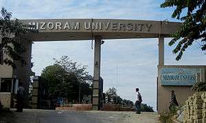
Pachhunga University College was among the earliest colleges founded in 1958. Aizawl College, the second oldest college in Aizawl City was established in the year 1975. Hrangbana College was established in 1980, located in Chanmari, Aizawl with Pu Lalrinawma as the Principal, it has 57 teaching staffs with 22 non - teaching Staffs and more than 2000 students in Commerce and Arts Departments. Mizoram University established in 2001 provides affiliation to all the Colleges in Mizoram. Mizoram University also provides post - graduate education as well as B.Tech education and other departments. ICFAI University, Mizoram located in Durtlang, Aizawl West College, Aizawl North College, J.Thankima College also provides Under Graduate courses. Mizoram Law College provides education to people who seek profession in Law.[29] Indian Institute of Mass Communication and National Institute of Technology Mizoram has already started operations. Plans are being made to start a medical college in Falkawn.[30]
Sports

Football is the most popular sport in Mizoram with a number of footballers playing in national leagues in different parts of India. Some of the more important playing facilities in Aizawl are:
- Rajiv Gandhi Stadium Mualpui, with a seating capacity of 20,000, is currently being constructed at Mualpui, Aizawl.[31]
- Hawla Indoor Stadium is the largest indoor stadium with basketball, badminton and boxing facilities.
- Lammual stadium is a single tier stadium. The stadium under construction will have a seating capacity of about 5,000 spectators.[32]
| Team | Sport | League | Venue |
|---|---|---|---|
| Mizoram football team | Football | Santosh Trophy | Rajiv Gandhi Stadium Mualpui |
| Aizawl F.C. | Football | I-League | Rajiv Gandhi Stadium Mualpui |
| Chanmari F.C. | Football | Mizoram Premier League | Lammual |
| Dinthar Football Club | Football | Mizoram Premier League | Lammual/Vaivakawn field |
Neighbourhoods
|
|
|
See also
References
- 1 2 3 4 5 6 "Aizawl City Census 2011 data". census2011.co.in. Retrieved 17 May 2018.
- ↑ "Definition of Aizawl". The Free Online Dictionary. Retrieved 31 October 2013.
- ↑ "Aizawl City Population". census2011.co.in. Archived from the original on 28 October 2013. Retrieved 15 August 2012.
- ↑ "Aizawl will host the third edition of Xchange North East Youth NGO summit from October 3rd to 5th,2018".
- ↑ K. C. Kabra (2008). Economic Growth of Mizoram: Role of Business & Industry. Concept Publishing Company. ISBN 9788180695186.
- ↑ The Making of Aijal Archived 12 November 2013 at the Wayback Machine.
- ↑ Hamlet Bareh (2001). Encyclopaedia of North-East India: Mizoram. Mittal Publications. pp. 206–216. ISBN 978-81-7099-787-0.
- ↑ "Aizawl - the State Capital". Mizoram. Archived from the original on 7 October 2013. Retrieved 9 November 2012.
- ↑ "World Weather Information Service–Aizawl". World Meteorological Organization. Archived from the original on 6 May 2012. Retrieved 16 May 2014.
- ↑ Chetri, Pratap. "Aizawl Gets Its First Municipal Council". Eastern Panorama. Retrieved 14 August 2012.
- ↑ Dr. L.H.Chhuanawma. "Aizawl Municipal Council". T Romana College. Archived from the original on 28 May 2013. Retrieved 7 September 2012.
- ↑ "Census of India 2001: Data from the 2001 Census, including cities, villages and towns (Provisional)". Census Commission of India. Archived from the original on 16 June 2004. Retrieved 1 November 2008.
- 1 2 "Inner Line Permit (ILP): Mizoram". mizoram.nic.in. Retrieved 2018-01-08.
- ↑ "Mizorama Helicopter Service Tur Chief Minister in Hawng". Mizoram DIPR. Archived from the original on 12 December 2013. Retrieved 14 August 2012.
- ↑ "Nilaini atangin 'Helicopter Service". The Zozam Times. Archived from the original on 23 September 2015. Retrieved 20 August 2012.
- ↑ "Mizoram Chhunga Helicopter Service Scheduled Thar". DIPR: Govt of Mizoram. Archived from the original on 23 September 2015. Retrieved 23 September 2015.
- ↑ PTI. "Broad gauge track project in Mizoram to be over by March 2015". CNN IBN Live. Retrieved 13 August 2012.
- ↑ "Accredited Journalists". DIPR Mizoram. Archived from the original on 19 June 2013. Retrieved 5 September 2012.
- ↑ "Vanglaini - Mizo Daily Since 1978". vanglaini.org. Archived from the original on 1 April 2014. Retrieved 30 June 2010.
- ↑ "The Zozam Times". Archived from the original on 7 January 2014. Retrieved 7 September 2012.
- ↑ "The Aizawl Post". Archived from the original on 3 January 2014. Retrieved 7 September 2012.
- ↑ "Virthli". Archived from the original on 27 March 2013. Retrieved 7 September 2012.
- ↑ "The Mizoram Post". Archived from the original on 11 November 2013. Retrieved 7 September 2012.
- ↑ "Zozam Weekly". Archived from the original on 18 May 2014. Retrieved 7 September 2012.
- ↑ "AIR buatsaih FM Zoawi chu le". Vanglaini. Retrieved 27 August 2012.
- ↑ "Hmuifang Tourist Resort". Govt of Mizoram. Retrieved 24 August 2012.
- ↑ "Biggest family: Ziona Chana has 39 wives and 94 children: a world record". worldrecordsacademy.org. 21 February 2011. Retrieved 24 October 2011.
- ↑ Kohhran, Thianghlim. "Solomon's Temple". Archived from the original on 24 December 2013. Retrieved 30 December 2013.
- ↑ The Mizoram University Act of 25 April 2000 Archived 3 August 2012 at the Wayback Machine.
- ↑ "Central Health Services Leh Aiims Doctor Ten Chief Minister HMU". DIPR. Archived from the original on 1 February 2014. Retrieved 15 August 2012.
- ↑ tirhkahthawla. "Mualpui Stadium Design". misual.com. Archived from the original on 27 May 2013. Retrieved 14 August 2012.
- ↑ "Lammual-ah Gallery sak hna tan dawn ta". The Zozam Times. Archived from the original on 15 April 2013. Retrieved 16 August 2012.
External links
| Wikimedia Commons has media related to Aizawl. |

- Aizawl Development Authority
- Aizawl Official Website
- Regency Aizawl Official Website
| State symbols | |
|---|---|
| Government | |
| Topics | |
| Districts | |
| Urban Areas | |
| Infrastructure | |
| Education | |
| Tourism | |
| Protected areas | |
|