Kohima
| Kohima | |
|---|---|
| Capital city | |
 Kohima Location of Kohima in Nagaland  Kohima Kohima (India) | |
| Coordinates: 25°40′12″N 94°06′28″E / 25.6701°N 94.1077°ECoordinates: 25°40′12″N 94°06′28″E / 25.6701°N 94.1077°E | |
| Country |
|
| State | Nagaland |
| District | Kohima |
| Government | |
| • Type | Municipality |
| • Body | Kohima Municipal Council |
| Area | |
| • Total | 20 km2 (8 sq mi) |
| Elevation | 1,444 m (4,738 ft) |
| Population (2011) | |
| • Total | 99,039[1] |
| Languages | |
| • Official | English |
| Time zone | UTC+5:30 (IST) |
| PIN | 797001 |
| Telephone code | 91 (0)370 |
| Vehicle registration | NL-01 |
| Sex ratio | 927 ♂/♀ |
| Website |
kohima |
Kohima (/koʊˈhiːmə/ ![]()
Kohima is the land of the Angami Naga tribe. It is situated in the foothills of Japfu range located south of Kohima District (25°40′N 94°07′E / 25.67°N 94.12°E)[2] and has an average elevation of 1261 metres (4137 feet).[3]
Etymology
Kohima was originally known as Kewhira. The name, Kohima, was officially given by the British as they could not pronounce the Angami name of Kewhira (Tenyidie for "the land where the flower Kewhi grows"). It is called after the wild flowering plant Kewhi, found in the mountains. Most local people prefer to use 'Kewhira'.
History
Kohima was originally a large village named Kewhira, which is located in the North-Eastern part of the present day Kohima urban area. The village is divided into four Thinuos namely - Tsütuonuomia, Lhisemia, Dapfütsumia and Pfuchatsumia. They are termed shortly as T, L, D, and P Khel respectively.
Battle of Kohima
The British incursions into the Naga territory, beginning in the 1840s, met with stiff resistance from the independence-loving Nagas, who had never been conquered by any empire before. The stiffness of the resistance can be gauged by the fact that it took nearly four decades for the British to conquer a territory that is less than 10,000 square kilometres (the eastern region was left free). Kohima was the first seat of modern administration as the Headquarters of Naga Hills District (then under Assam) with the appointment of Guybon Henry Damant as Political Officer in 1879. When Nagaland became a full-fledged state on 1 December 1963, Kohima was christened as the state capital.
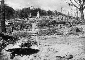
In 1944 during World War II the Battle of Kohima along with the simultaneous Battle of Imphal was the turning point in the Burma Campaign. For the first time in South-East Asia the Japanese lost the initiative to the Allies which they then retained until the end of the war. This hand-to-hand battle and slaughter prevented the Japanese from gaining a high base from which they might next roll across the extensive flatlands of India.[4]
.jpeg)
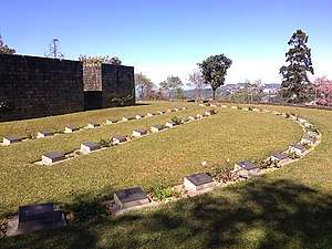
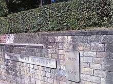
Kohima has a large cemetery known as the War Cemetery in Kohima for the Allied war dead maintained by the Commonwealth War Graves Commission. The cemetery lies on the slopes of Garrison Hill, in what was once the Deputy Commissioner's tennis court which was the scene of intense fighting, the Battle of the Tennis Court. The epitaph carved on the memorial of the 2nd British Division in the cemetery
| “ | When You Go Home, Tell Them Of Us And Say,
|
” |
has become world-famous as the Kohima poem. The verse is attributed to John Maxwell Edmonds (1875–1958), and is thought to have been inspired by the epitaph written by Simonides to honour the Greek who fell at the Battle of Thermopylae in 480 BC.[5]
Geography
Kohima lies north of the Japfü Barail intersection. Due to its elevation, Kohima features a more moderate version of a humid subtropical climate (Cwa). Kohima has cool winters and hot very rainy summers. The coldest months are from December to February, when frost occurs and in the higher altitudes snowfall occurs occasionally. During the height of summers, from June–August, temperature ranges an average of 27–32 °C (80–90 °F). Heavy rainfall occurs during summer.
Climate
| Climate data for Kohima | |||||||||||||
|---|---|---|---|---|---|---|---|---|---|---|---|---|---|
| Month | Jan | Feb | Mar | Apr | May | Jun | Jul | Aug | Sep | Oct | Nov | Dec | Year |
| Record high °C (°F) | 23.5 (74.3) |
25.0 (77) |
29.1 (84.4) |
32.2 (90) |
33.9 (93) |
30.5 (86.9) |
33.1 (91.6) |
31.1 (88) |
31.0 (87.8) |
31.5 (88.7) |
29.5 (85.1) |
26.0 (78.8) |
33.9 (93) |
| Average high °C (°F) | 16.6 (61.9) |
17.9 (64.2) |
22.1 (71.8) |
24.1 (75.4) |
24.4 (75.9) |
24.9 (76.8) |
25.0 (77) |
25.4 (77.7) |
25.0 (77) |
23.4 (74.1) |
20.6 (69.1) |
17.7 (63.9) |
22.2 (72) |
| Average low °C (°F) | 8.1 (46.6) |
9.3 (48.7) |
12.7 (54.9) |
15.6 (60.1) |
16.9 (62.4) |
18.1 (64.6) |
18.8 (65.8) |
18.9 (66) |
18.1 (64.6) |
16.6 (61.9) |
13.1 (55.6) |
9.4 (48.9) |
14.6 (58.3) |
| Record low °C (°F) | 1.0 (33.8) |
2.3 (36.1) |
4.0 (39.2) |
5.0 (41) |
10.0 (50) |
9.4 (48.9) |
7.8 (46) |
8.3 (46.9) |
8.9 (48) |
5.0 (41) |
3.1 (37.6) |
2.8 (37) |
1.0 (33.8) |
| Average rainfall mm (inches) | 11.7 (0.461) |
35.4 (1.394) |
47.6 (1.874) |
88.7 (3.492) |
159.2 (6.268) |
333.8 (13.142) |
371.8 (14.638) |
364.0 (14.331) |
250.1 (9.846) |
126.0 (4.961) |
35.2 (1.386) |
7.8 (0.307) |
1,831.3 (72.098) |
| Average rainy days | 2.0 | 3.9 | 5.8 | 12.2 | 16.9 | 23.1 | 24.6 | 22.9 | 19.1 | 10.7 | 3.6 | 1.4 | 146.2 |
| Source #1: World Meteorological Organization[6] | |||||||||||||
| Source #2: India Meteorological Department (record low and high up to 2010)[7] | |||||||||||||
Administration
The Kohima Municipal Council (KMC) was established in 2005 under India's Constitution (Seventy-Fourth Amendment) Act, 1992. It has waste management, drainage and trade licensing and other responsibilities.[8][9]
Other departments of the state government, which sit in Kohima, also have a role in the administration of Kohima.[9] The "City Development Plan" for the town, for example, was written by state Urban Development Department.[10]
Greater Kohima planning area
The Greater Kohima Planning Area (GKPA) comprises the KMC plus Kohima, Meriema, Tsiesema and Thizama villages and their peripheral, cultivable and conservation areas, and the "Capital Complex Area". The total area of the GKPA is 63.36 sq km, of which municipal council's 11 sq km accounts for just over 17%.[10][11][9]
Demographics
As of 2011, Kohima had a population of 99,039 of which males and females were 51,626 and 47,413 respectively. Kohima has an average literacy rate of 90.76%, higher than the national average of 79.55%.[1]
The city's population is composed of the 16 tribes of Nagaland. The population of the Angamis and Aos are the largest in present-day Kohima urban area.
The major religion in Kohima is Christianity which is practised by 80.22% of the population. Other religions includes Hindu (16.09%), Muslim (3.06%) and Buddhist (0.45%).[1]
As of 2011 six of Kohima's nineteen wards, covering 26% of the town, have been designated as slums, within which about a third of the population was Below Poverty Line.[10]
The Greater Kohima planning area had a population of 115,283 at the 2001 census, of which the KMC area accounted for 67% and Kohima Village 16%.[10]
Hornbill Festival
The Hornbill Festival[12] was first initiated and proposed as Winter Carnival 2000 by BASN (Beauty and Aesthetics Society of Nagaland) before it was taken over by the Government of Nagaland who launched it in December 2000 as Hornbill Festival to encourage intertribal interaction and to promote the cultural heritage of the state. Organized by the State Tourism and Art and Culture Departments, Hornbill Festival showcases cultural displays under one roof. The festival takes place between the 1st and 10 December every year.
The week-long Hornbill Festival is held at Kisama Heritage Village, Kisama which is about 12 km from Kohima, the capital of Nagaland. All the tribes of Nagaland take part in this festival. The aim of the festival is to revive and protect the rich culture of Nagaland and display its traditions.[13]
The festival is named after the hornbill, which is mentioned in the folklore of most of the state’s tribes. People enjoy the colourful performances, crafts, sports, food fairs, games and ceremonies. Traditional arts which include paintings, wood carvings, and sculptures are on display. Festival highlights include Naga Morong, exhibition and sale of arts and crafts, food stalls, herbal medicine stalls, flower shows and sales, food and beverage stalls-showcasing the tribes beverages in dragons sized wooden casks. cultural medley - songs and dances, fashion shows, beauty contest, archery, Naga wrestling, indigenous games and musical concerts. Additional attractions include Konyak fire eating demonstration, pork fat eating competitions, literature fest, Hornbill Global Film Fest, Hornbill Ball, Choral Panorama, North East India Drum Ensemble, Naga King Chilly eating competition, Hornbill National Rock Contest,[14] Hornbill International Motor Rally and WW-II Vintage Car Rally.[15][16]
Transport
The nearest airport is Dimapur Airport at Dimapur about 74 kilometres (46 miles) away. Kohima is connected by road with National Highways 2 and 29 passing through the city. Kohima is not connected with the rail network. The nearest railway station is at Dimapur. An extension of the railway line from Dimapur to Kohima was proposed and surveyed in 2009.[17] Due to a dispute over land acquisition the track was resurveyed and an alternative alignment was proposed in 2013 and is expected to be completed by 2020.[18]
Education
Schools
Universities and Colleges
- Japfü Christian College, Kigwema, Kohima
- Kohima Science College, Jotsoma
- Model Christian College, Kohima
- St. Joseph's College, Jakhama, Kohima
- Nagaland University, Meriema campus, Kohima
Sports
Football
Kohima is home to Kohima Komets a football club which plays in the top division Nagaland Premier League.
Media and communications
State-owned All India Radio has a local station in Kohima, which transmits various programs of mass interest.
Gallery


See also
References
- 1 2 3 4 "Kohima City Population Census 2011 - Nagaland". 2011 Census of India. 2015.
- ↑ "Maps, Weather, and Airports for Kohima, India". Retrieved 10 June 2015.
- ↑ "Kohima Home NIC". Retrieved 10 June 2015.
- ↑ Bert Sim, Mosstodloch, Aberdeenshire, Scotland: Pipe Major of the Gordon Highlanders at Kohima: his home is named "Kohima." -- RJWilliams, Slingerlands, NY/USA
- ↑ "Epitaph". Archived from the original on 10 May 2015. Retrieved 10 June 2015.
- ↑ "World Weather Information Service–Kohima". World Meteorological Organisation. Archived from the original on 6 May 2012. Retrieved 16 May 2014.
- ↑ "Ever recorded Maximum and minimum temperatures upto 2010" (PDF). India Meteorological Department. Archived from the original (PDF) on 21 May 2013. Retrieved 18 January 2014.
- ↑ "Kohima Municipal Council, Location of Kohima Municipal Council". kohimaonline.in. India Online.
- 1 2 3 "Administration of Kohima, Kohima District Administration". kohimaonline.in. India Online.
- 1 2 3 4 "Kohima CDP Revised" (PDF). Government of Nagaland. July 2006.
- ↑ "Kohima Municipal Council". kmc.nagaland.gov.in. 31 March 2017.
- ↑ "Hornbill Festival 2015 - Hornbillfestival.com". Retrieved 10 June 2015.
- ↑ Hornbill Festival www.festivalsofindia.in
- ↑ Hornbill National Rock Contest official website
- ↑ 2 crore 7-day Hornbill Festival to enthrall nagalandpost.com retrieved 3-12-2011
- ↑ Hornbill International Motor Rally starts nagalandpost.com retrieved 3-12-2011
- ↑ Sechü, Neidilhoutuo (26 July 2013). "Slow Train Ride to Zubza". Eastern Mirror. Archived from the original on 4 December 2014. Retrieved 23 May 2018.
- ↑ "The Sentinel". Retrieved 10 June 2015.
External links
| Wikimedia Commons has media related to Kohima. |

- Official website
|