Domjur
| Domjur | |
|---|---|
| Census Town | |
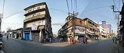 Amta road (SH-15) and Jagadishpur road junction | |
 Domjur Location in West Bengal, India | |
| Coordinates: 22°38′N 88°13′E / 22.64°N 88.22°ECoordinates: 22°38′N 88°13′E / 22.64°N 88.22°E | |
| Country |
|
| State | West Bengal |
| District | Howrah |
| Elevation | 11 m (36 ft) |
| Population (2011) | |
| • Total | 18,433 |
| Languages | |
| • Official | Bengali, English |
| Time zone | UTC+5:30 (IST) |
| Lok Sabha constituency | Sreerampur |
| Vidhan Sabha constituency | Domjur, Jagatballavpur |
| Website |
howrah |
Domjur is a census town in Domjur (community development block) in Sadar subdivision of Howrah district in the Indian state of West Bengal.
Geography
Domjur is located at 22°38′N 88°13′E / 22.64°N 88.22°E.[1] It has an average elevation of 11 metres (36 feet).
Demographics
As per 2011 Census of India Domjur had a total population of 18,433 of which 9,040 (49%) were males and 9,393 (51%) were females. Population below 6 years was 1,725. The total number of literates in Domjur was 14,396 (86.16% of the population over 6 years).[2]
Domjur was part of Kolkata Urban Agglomeration in 2011 census.[3]
As of 2001 India census,[4] Domjur had a population of 16,822. Males constitute 50% of the population and females 50%. Domjur has an average literacy rate of 69%, higher than the national average of 59.5%: male literacy is 73% and, female literacy is 65%. In Domjur, 10% of the population is under 6 years of age.
Sastitala is the most biggest area of Domjur. Domjur has a large number of population belonging to Schedule Caste group. Hindus form about the two-thirds of the population, whereas Muslims make up about one-third.
Culture and Festivals

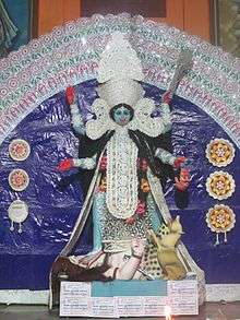

Similar to the rest of Bengal, Durga Puja, Kali Puja, Eid al-Fitr and Christmas are the major festivals celebrated here.Peace and Tranquillity can be seen everywhere in this town.
Transport
Domjur Road is 25.29 kilometres (15.71 mi) and Domjur is 26.23 kilometres (16.30 mi) from Howrah Station.[5] Domjur is part of the Kolkata Suburban Railway railway system.
Health Service
Domjur has its own hospital. Apart from that, there are many nursing homes and polyclinics in the area.
References
- ↑ Falling Rain Genomics, Inc - Domjur
- ↑ "C.D. Block Wise Primary Census Abstract Data(PCA)". 2011 census: West Bengal – District-wise CD Blocks. Registrar General and Census Commissioner, India. Retrieved 11 May 2016.
- ↑ "Provisional Population Totals, Census of India 2011" (PDF). Constituents of Urban Agglomeration Having Population Above 1 Lakh. Census of India 2011. Retrieved 11 May 2016.
- ↑ "Census of India 2001: Data from the 2001 Census, including cities, villages and towns (Provisional)". Census Commission of India. Archived from the original on 2004-06-16. Retrieved 2008-11-01.
- ↑ "Distances in kilometres between stations" (PDF). Indian Railways. Retrieved 2009-02-07.
Cities, towns and locations in Howrah District | |
|---|---|
| Cities, municipal and census towns | |
| Locations other than cities and towns | |
| Related topics |
|