Gadiara
| Gadiara | |
|---|---|
| village | |
 Gadiara Location in West Bengal, India  Gadiara Gadiara (India) | |
| Coordinates: 22°13′N 88°03′E / 22.22°N 88.05°ECoordinates: 22°13′N 88°03′E / 22.22°N 88.05°E [1] | |
| Country |
|
| State | West Bengal |
| District | Howrah |
| Government | |
| • Body | Gram panchayat |
| Languages | |
| • Official | Bengali, English |
| Time zone | UTC+5:30 (IST) |
| Vehicle registration | WB |
| Nearest city | Howrah, Kolkata |
| Lok Sabha constituency | Uluberia |
| Vidhan Sabha constituency | Shyampur |
| Website |
howrah |
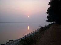
Sunset at Gadiara
Gadiara is a village in the Howrah District of West Bengal, India. It is the point of convergence of the Damodar, the Rupnarayan and the Hoogli rivers. It is near 100 km from Kolkata. Gadiara is a popular picnic and daytrip spot for locals and tourists alike. Gadiara has an old fort, Fort Mornington, which was built by Lord Clive; it was heavily damaged during flooding in 1942.
External links

- Birding at Gadiara, Howrah
References
- ↑ "Yahoo maps location of Gadiara". Yahoo maps. Retrieved 2008-12-30.
Cities, towns and locations in Howrah District | |
|---|---|
| Cities, municipal and census towns | |
| Locations other than cities and towns | |
| Related topics |
|
This article is issued from
Wikipedia.
The text is licensed under Creative Commons - Attribution - Sharealike.
Additional terms may apply for the media files.