Blanton, Oklahoma
| Blanton, Oklahoma | |
|---|---|
| Unincorporated community | |
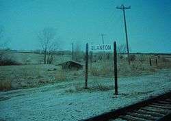 Blanton railroad stop in the mid-1990s | |
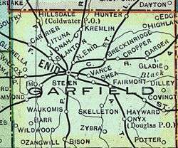 1909 map of Garfield County, Oklahoma with Blanton. | |
| Coordinates: 36°25′38″N 97°55′35″W / 36.42722°N 97.92639°WCoordinates: 36°25′38″N 97°55′35″W / 36.42722°N 97.92639°W | |
| Country | United States |
| State | Oklahoma |
| County | Garfield |
| Elevation | 1,240 ft (1,314 m) |
| Time zone | UTC-6 (CST) |
| • Summer (DST) | UTC-5 (CDT) |
| Area code(s) | 580 |
| GNIS feature ID | 1100216 |
Blanton is an unincorporated community[1] in Garfield County, Oklahoma, United States. It was a rail stop for two rail lines,[2] one of which used to transport grain until the mid-1990s.[3] It was named after Denver, Enid and Gulf Railroad (DE&G) executive W. B. Blanton.[4]
History
As early as 1909, Blanton was a rail stop for the St. Louis-San Francisco Railway.[2] A second rail line existed at Blanton junction, running to Kiowa, Kansas. This line, originally built for the DE&G in 1904 and 1905[5], and later sold to Atchison, Topeka and Santa Fe was used to transport grain until the mid-1990s.[3] The junction was named after W. B. Blanton, who was the second superintendent of the DE&G.[5]
Geography
Blanton is located at 36°25′38″N 97°55′35″W / 36.42722°N 97.92639°W, 3.4 miles (5.5 km) west-northwest of Enid, Oklahoma. It is a part of the Lower Cimarron-Skeleton Watershed.[6]
Blanton is currently located on mile 548.2 of the main track of BNSF Railway's Texas Division.[7]
References
- ↑ "Blanton, Oklahoma". Geographic Names Information System. United States Geological Survey. Retrieved 2008-08-04.
- 1 2 Historical Maps of Oklahoma, University of Alabama (accessed May 30, 2010).
- 1 2 The Surface Transportation Board: Docket Number: AB_480_0_X (accessed May 30, 2010).
- ↑ Cammalleri, Joseph A., Guthrie, Oklahoma: Always a Railroad Town, pp. 43-44
- 1 2 George, Preston; Wood, Sylvan R. (January 1943). "The Railroads of Oklahoma". Railway and Locomotive Historical Society Bulletin. 60: 38. JSTOR 43516811.
- ↑ U.S. EPA. "Lower Cimarron-Skeleton Watershed -- 11050002. Surf Your Watershed". Retrieved 2008-08-04.
- ↑ BNSF Railway. "Texas Division Map, January 1, 2005" (PDF). Retrieved 2008-08-05.
Municipalities and communities of Garfield County, Oklahoma, United States | ||
|---|---|---|
| Cities | 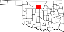 | |
| Towns | ||
| CDP | ||
| Unincorporated communities | ||