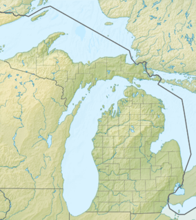
Straits of Mackinac
| Straits of Mackinac | |
|---|---|
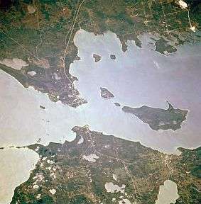 Overhead view of the Straits of Mackinac linking Lakes Michigan (left) and Huron (right) | |
 Straits of Mackinac 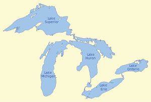 Straits of Mackinac  Straits of Mackinac | |
| Location | Lake Michigan-Lake Huron |
| Coordinates | 45°48′50″N 84°45′00″W / 45.81389°N 84.75000°WCoordinates: 45°48′50″N 84°45′00″W / 45.81389°N 84.75000°W |
| Type | Strait |
| Etymology | Michilimackinac |
| Basin countries |
|
| Max. depth | 295 feet (90 m) |
| Islands | |
| Settlements | |
The Straits of Mackinac (/ˈmækɪnɔː/ MAK-in-aw) are a series of narrow waterways in the U.S. state of Michigan, between Michigan's Lower and Upper Peninsulas. The main strait flows under the Mackinac Bridge and connects two of the Great Lakes, Lake Michigan and Lake Huron. The main strait is 3.5 miles (5.6 km) wide and has a maximum depth of 295 feet (90 m).[1] Hydrologically, the two connected lakes can be considered one, which is called Lake Michigan–Huron. Historically, the region around the Straits was known by the native Odawa people as Michilimackinac. The Straits of Mackinac is "whipsawed by currents unlike anywhere else in the Great Lakes."[2]
History
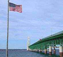
The Straits of Mackinac is a major shipping lane, providing passage for raw materials and finished goods and connecting, for instance, the iron mines of Minnesota to the steel mills of Gary, Indiana. Before the railroads reached Chicago from the east, most immigrants arrived in the Midwest and Great Plains by ships on the Great Lakes. The straits is five miles (8 km) wide at its narrowest point, where it is spanned by the Mackinac Bridge. Before the bridge was built, car ferries transported vehicles across the straits. Today passenger-only ferries carry people to Mackinac Island, which does not permit cars. Visitors can take their vehicles on a car ferry to Bois Blanc Island.
Islands in the Straits of Mackinac include the two populated islands, Bois Blanc and Mackinac, and two that are uninhabited: Round and St. Helena islands. At 11 miles (18 km) in length, Bois Blanc is the largest island in the straits.
The straits are shallow and narrow enough to freeze over in the winter. Navigation is ensured for year-round shipping to the Lower Great Lakes by the use of icebreakers.
The straits were an important Native American and fur trade route. The Straits of Mackinac are named after Mackinac Island. The local Ojibwe Native Americans in the Straits of Mackinac region likened the shape of the island to that of a turtle, so they named the island Mitchimakinak, meaning "Big Turtle".[3] When the British explored the area, they shortened the name to its present form: Mackinac.[4][5]
Located on the southern side of the straits is the town of Mackinaw City, the site of Fort Michilimackinac, a reconstructed French fort founded in 1715, and on the northern side is St. Ignace, site of a French Catholic mission to the Indians, founded in 1671. The eastern end of the straits was controlled by Fort Mackinac on Mackinac Island, a British colonial and early American military base and fur trade center, founded in 1781.
Today
The straits are patrolled by a detachment of the United States Coast Guard based at Graham Point, St. Ignace. A shipping channel through the winter ice is maintained by the Coast Guard's Great Lakes icebreaker, USCGC Mackinaw, based in Cheboygan near the eastern edge of the Straits. This vessel went into service during the 2005/06 ice season.
Most of the Straits have been set aside by the state of Michigan as the Straits of Mackinac Shipwreck Preserve, a riparian public space dedicated to those personnel who were lost aboard the boats and ships that sank in these dangerous shipping lanes.
Lighthouses in the Straits of Mackinac include:
- The McGulpin Point Light, on McGulpin Point, three miles (4.8 km) west of Fort Michilimackinac.
- The Old Mackinac Point Light, in Mackinaw City, which is open to the public.
- The Round Island Light on Round Island, which is not open to the public but which can be viewed from the Mackinac Island ferry channel.
- The St. Helena Island Lighthouse, which is not open to the public but is visible from a rest area on U.S. Highway 2 at Gros Cap west of St. Ignace.
- The Bois Blanc Light, which is not open to the public, on the northern shore of Bois Blanc.

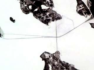
Enbridge pipeline
West of the iconic Mackinac Bridge is Enbridge's pipeline, called Enbridge Line 5, which was built in 1953 as an extension of the one-thousand-one-hundred-and-fifty-mile (1,850 km) Interprovincial Pipe Line Company line bringing oil from Alberta to Lake Superior.[6] The 1953 pipeline enters the Straits of Mackinac water on the north shore at St. Ignace, Michigan and lies along the bottom of the Straits which is nearly two hundred and fifty feet (76 m) in places.[2] By 2013 Enbridge had increased the "maximum capacity on the lines to 540,000 barrels per day."[2] In selling the idea of the pipeline to residents living near the Straits, the pipeline developers claimed, it was "essential to the defense of the United States and the whole North American continent".[2] Mackinac pipes were specifically engineered to withstand the Straits’ brutal underwater environment. Even some of the company’s staunchest critics concede the twin lines, old as they may be, remain an engineering marvel."[2]
See also
References
- ↑
- 1 2 3 4 5 Dan Egan (January 18, 2017), Dangerous Straits, A Journal Sentinel Special Report, Milwaukee Journal Sentinel, retrieved February 11, 2017
- ↑ Nichols, John D.; Nyholm, Earl (1995). A Concise Dictionary of Minnesota Ojibwe. Minneapolis: University of Minnesota Press.
- ↑ Harper, Douglas. "Mackinaw". Online Etymology Dictionary. Retrieved March 8, 2007.
- ↑ Ferjutz, Kelly. "Broadcloth, Brocade and Buckskin—Return to the past on Mackinac Island". FrugalFun.com. Retrieved March 8, 2007.
- ↑ Flesher, John (March 3, 2014). "Submerged Enbridge Pipeline Under Michigan's Straits of Mackinac Raises Spill Fears". The Huffington Post. Associated Press. Retrieved February 11, 2017.
External links
| Wikimedia Commons has media related to Straits of Mackinac. |
- Straits of Mackinac Shipwreck
- Lighthouses in the Mackinac Strait
- Lighthouses of the Straits of Mackinac
| Central cities | |
|---|---|
| Counties | |
| Geography | |
| Transportation | |
| Economy | |
| Central cities | |
|---|---|
| Counties | |
| Geography | |
| Transportation | |
| Economy | |
| Main lakes | 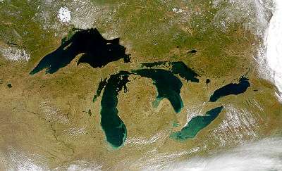 | |
|---|---|---|
| Secondary lakes | ||
| Bays and Waterways |
| |
| Islands | ||
| Historic geology | ||
| Government | ||
| Related topics | ||
| Authority control |
|---|