County Leitrim
| County Leitrim Contae Liatroma | ||
|---|---|---|
| ||
 | ||
| Coordinates: 54°07′01″N 8°00′00″W / 54.117°N 8.000°WCoordinates: 54°07′01″N 8°00′00″W / 54.117°N 8.000°W | ||
| Country | Ireland | |
| Province | Connacht | |
| Dáil Éireann | Sligo–Leitrim | |
| EU Parliament | Midlands–North-West | |
| County town | Carrick-on-Shannon | |
| Government | ||
| • Type | County Council | |
| Area | ||
| • Total | 1,590 km2 (610 sq mi) | |
| Area rank | 26th | |
| Population (2011)[1] | 31,972 | |
| • Rank | 32nd | |
| Vehicle index mark code | LM | |
| Website |
leitrim | |

County Leitrim (/ˈliːtrəm/ LEE-trəm, Irish: Contae Liatroma) is a county in the Republic of Ireland. It is in the province of Connacht and is part of the Border Region. It is named after the village of Leitrim. Founded in the early modern period, the county encompasses the historic Gaelic territory of West Bréifne corresponding to the northern part of the county,[2][3] and Muintir Eolais or Conmaicne Réin, corresponding to the southern part. Leitrim County Council is the local authority for the county, which had a population of 31,972 according to the 2016 census.[1]
Geography and political subdivisions
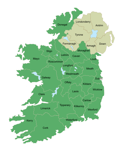
Leitrim is the 26th largest of the 32 counties by area and the smallest by population on the island.[4] It is the smallest of Connacht's 5 counties in both size and population. Leitrim is bordered by the counties of Donegal to the north, Fermanagh to the north-east, Cavan to the east, Longford to the south, Roscommon to the south-west and Sligo to the west. Fermanagh is in Northern Ireland while all the other neighbouring counties are within the Republic of Ireland.
Baronies
There are five historic baronies in the county. While baronies continue to be officially defined units, they are no longer used for many administrative purposes. Their official status is illustrated by Placenames Orders made since 2003, where official Irish names of baronies are listed under "Administrative units". They are Carrigallen, Drumahaire, Leitrim, Mohill and Rosclogher.[5]
Largest Towns in County Leitrim
As of the 2016 census:[6]
- Carrick-on-Shannon*, 4,062 (A small part of Carrick-on-Shannon is in County Roscommon)
- Manorhamilton, 1,466
- Kinlough, 1,032
- Ballinamore, 914
- Drumshanbo, 902
- Mohill, 855
- Dromahair, 808
- Leitrim, 594
- Roosky*, 564 (Most of Roosky is in County Roscommon)
- Dromod, 555
Towns and villages in north Leitrim
- Allentown, County Leitrim
- Askill
- Ballinaglera
- Buckode
- Cloonsheerevagh
- Drumkeeran
- Dromahair
- Dowra
- Friarstown
- Glenfarne
- Glenade
- Kiltyclogher
- Kinlough
- Killarga
- Largydonnell
- Lurganboy
- Manorhamilton
- Rossinver
- Tullaghan
Towns and villages in south Leitrim
Geography

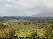
Leitrim has a hilly and mountainous landscape in its north-west and is relatively flat in the south-east, each separated from the other by Lough Allen in the middle of the county. Leitrim has the shortest length of coastline of any Irish county that touches the sea. At Tullaghan, the coastline is only 2.5 miles (4.0 km) long.[7] The Shannon is linked to the Erne via the Shannon-Erne Waterway. Notable lakes include:
- Lough Melvin
- Lough Allen
- Lough Gill is to the northwest of Dromahair; Parke's Castle is located on the lake shore.
- Belhavel Lough is also located in Dromahair, within the parish of Killargue.
- Lough Scur, and Saint John's Lough, on the Shannon–Erne Waterway.
- Other lakes include Upper Lough MacNean, Glencar Lough, Glenade Lough, Garadice Lough, Rinn Lough, Lough Scannal, Lough Erril and Lough Machugh.
History
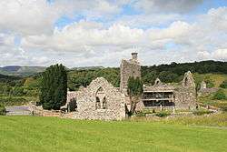
In ancient times Leitrim formed the western half of the Kingdom of Breifne. This region was long influenced by the O'Rourke family of Dromahair, whose heraldic lion occupies the official county shield to this day. Close ties initially existed with the O'Reilly clan in the eastern half of the kingdom, however a split occurred in the 13th century and the kingdom was divided into East Breifne, now County Cavan, and West Breifne, now County Leitrim. The Normans invaded south Leitrim in the 13th century but were defeated at the Battle of Áth an Chip in 1270.
Much of the county was confiscated from its owners in 1620 and given to Villiers and Hamilton. Their initial objective was to plant the county with English settlers. However, this proved unsuccessful. English Deputy Sir John Perrot had ordered the legal establishment of "Leitrim County" a half-century prior, in 1565. Perrott also demarcated the current county borders around 1583.
Long ago Ireland was covered in woodland,[8][9] and five great forests are traditionally said to have stood in Leitrim, with a 19th century county survey stating- "a hundred years ago almost the whole country was one continued, undivided forest, so that from Drumshanbo to Drumkeeran, a distance of nine or ten miles, one could travel the whole way from tree to tree by branches".[10] Many of these great forests were denuded for the making of charcoal for iron works around Slieve Anierin.[8] Working of the county's rich deposits of iron ore began in the 15th century and continued until the mid 18th century. Coal mining became prominent in the 19th century to the east of Lough Allen at Slieve Anierin and also to the west in Arigna, on the Roscommon border. The last coal mine closed in July 1990 and there is now a visitor centre.[11] Sandstone was also quarried in the Glenfarne region.
Writing in 1791, the geographer Beaufort suggested the county housing population encompassed 10,026 homes with "upwards of 50,000 inhabitants", the primary agriculture being cattle production, and the growth of flax sustaining the linen industry.[12] Leitrim was first hit by the recession caused by the mechanisation of linen weaving in the 1830s and its 155,000 residents (as of the 1841 census) were ravaged by the Great Famine and the population dropped to 112,000 by 1851. The population subsequently continued to decrease due to emigration. After many years, the wounds of such rapid population decline have finally started to heal. Agriculture improved over the last century. Leitrim now has the fastest growing population in Connacht.
The Book of Fenagh is the most famous medieval manuscript originating here. In the 19th century the poet John McDonald (of Dromod) lived in the county, and William Butler Yeats spent the turn of the twentieth century fascinated with Lough Allen and much of Leitrim. Glencar Waterfall, 11 kilometres (7 mi) from Manorhamilton, inspired Yeats and is mentioned in his poem The Stolen Child.
Demographics

- Leitrim has the fastest growing population of any county in Connacht. As measured by census, the population rose by 12.2% between 2002 and 2006 to 29,000.[13]
- 2005 HEA statistics identified that Leitrim has the highest rate of participation in higher education in Ireland with 75% of 17- to 19-year-olds being admitted to a higher course.[14]
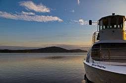
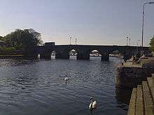
- The county town is Carrick-on-Shannon (population 3,314).[6] It is a highly developed, prospering river port on the River Shannon and many tourists hire cruising boats here to explore the Shannon and the Shannon-Erne Waterway -a 63 km canal linking the two river systems. It is amongst the fastest growing towns in Ireland having grown by 25% in the past few years.[15]
| Historical population | ||
|---|---|---|
| Year | Pop. | ±% |
| 1461 | 3,580 | — |
| 1471 | 3,910 | +9.2% |
| 1500 | 3,997 | +2.2% |
| 1510 | 4,061 | +1.6% |
| 1550 | 4,211 | +3.7% |
| 1580 | 4,408 | +4.7% |
| 1585 | 4,211 | −4.5% |
| 1600 | 3,581 | −15.0% |
| 1610 | 3,388 | −5.4% |
| 1611 | 3,581 | +5.7% |
| 1613 | 3,405 | −4.9% |
| 1616 | 3,371 | −1.0% |
| 1621 | 3,113 | −7.7% |
| 1631 | 3,224 | +3.6% |
| 1641 | 3,117 | −3.3% |
| 1651 | 3,065 | −1.7% |
| 1653 | 2,970 | −3.1% |
| 1659 | 4,275 | +43.9% |
| 1668 | 4,550 | +6.4% |
| 1672 | 4,707 | +3.5% |
| 1680 | 4,999 | +6.2% |
| 1681 | 5,244 | +4.9% |
| 1686 | 5,779 | +10.2% |
| 1689 | 6,444 | +11.5% |
| 1690 | 6,999 | +8.6% |
| 1691 | 7,515 | +7.4% |
| 1693 | 7,999 | +6.4% |
| 1695 | 8,333 | +4.2% |
| 1696 | 8,970 | +7.6% |
| 1697 | 9,554 | +6.5% |
| 1699 | 10,224 | +7.0% |
| 1700 | 10,475 | +2.5% |
| 1703 | 10,976 | +4.8% |
| 1705 | 11,960 | +9.0% |
| 1708 | 12,880 | +7.7% |
| 1710 | 13,110 | +1.8% |
| 1715 | 13,575 | +3.5% |
| 1718 | 14,020 | +3.3% |
| 1720 | 14,445 | +3.0% |
| 1721 | 14,975 | +3.7% |
| 1725 | 16,100 | +7.5% |
| 1727 | 16,330 | +1.4% |
| 1730 | 17,055 | +4.4% |
| 1735 | 17,775 | +4.2% |
| 1736 | 19,550 | +10.0% |
| 1739 | 21,224 | +8.6% |
| 1737 | 23,920 | +12.7% |
| 1745 | 25,799 | +7.9% |
| 1755 | 28,950 | +12.2% |
| 1765 | 38,992 | +34.7% |
| 1771 | 37,801 | −3.1% |
| 1775 | 68,707 | +81.8% |
| 1781 | 94,201 | +37.1% |
| 1788 | 108,402 | +15.1% |
| 1790 | 116,804 | +7.8% |
| 1801 | 115,801 | −0.9% |
| 1811 | 120,783 | +4.3% |
| 1813 | 101,211 | −16.2% |
| 1821 | 124,783 | +23.3% |
| 1831 | 141,524 | +13.4% |
| 1841 | 155,297 | +9.7% |
| 1851 | 111,897 | −27.9% |
| 1861 | 104,744 | −6.4% |
| 1871 | 95,562 | −8.8% |
| 1881 | 90,372 | −5.4% |
| 1891 | 78,618 | −13.0% |
| 1901 | 69,343 | −11.8% |
| 1911 | 63,582 | −8.3% |
| 1926 | 55,907 | −12.1% |
| 1936 | 50,908 | −8.9% |
| 1946 | 44,591 | −12.4% |
| 1951 | 41,209 | −7.6% |
| 1956 | 37,056 | −10.1% |
| 1961 | 33,470 | −9.7% |
| 1966 | 30,572 | −8.7% |
| 1971 | 28,360 | −7.2% |
| 1979 | 27,844 | −1.8% |
| 1981 | 27,609 | −0.8% |
| 1986 | 27,035 | −2.1% |
| 1991 | 25,301 | −6.4% |
| 1996 | 25,057 | −1.0% |
| 2002 | 25,799 | +3.0% |
| 2006 | 28,950 | +12.2% |
| 2011 | 31,798 | +9.8% |
| 2016 | 31,972 | +0.5% |
| [16] | ||
Local government and politics
| Party | Seats | Change |
| Fine Gael | 1 | |
| Fianna Fáil | 2 | |
| Sinn Féin | 1 |
Leitrim County Council is the local authority for the administrative county. The county is divided into three Local Electoral Areas for the purpose of elections:[17] Ballinamore (6 councillors), Carrick-on-Shannon (6 councillors), and Manorhamilton (6 councillors).
For elections to Dáil Éireann, Leitrim is in the Sligo–Leitrim constituency. This constituency existed from 1948 to 2007, but from 2007 until Sligo–Leitrim was re-created in 2016, County Leitrim was divided between two constituencies: Roscommon–South Leitrim and Sligo–North Leitrim. This proved controversial, and at the 2007 general election there was no TD elected whose domicile was in the county.
Transport
- Supplementing the local and regional road networks are the N15 (Sligo-Leitrim-Donegal), N16 (Sligo-Leitrim-Enniskillen) and N4 (Sligo-Leitrim-Dublin) national roads.
- Railway stations in Leitrim on the Dublin to Sligo line include Dromod and Carrick-on-Shannon.
- The Cavan and Leitrim Railway opened on 17 October 1887. It consisted of two branches, meeting at Ballinamore which connected Dromod and Arigna with Belturbet. Services carried goods, passengers and coal from around Lough Allen. Although protested, the line finally closed on 31 March 1959.
- Railway stations in Leitrim on the former Sligo, Leitrim and Northern Counties Railway (which ran between Sligo and Enniskillen) included Dromahair, Manorhamilton and Glenfarne.
- The Shannon and Shannon-Erne Waterway give access to much of Leitrim by boat.
People
- Margaret Haughery – Philanthropist, Margaret of New Orleans, known as "the mother of the orphans".
- Katherine Lynch – comedian.
- William Henry Drummond – Mohill-born Canadian poet.
- John McGahern – award winning Irish author and novelist.
- Pat Quinn – founder of Quinnsworth, Ireland's first supermarket chain.
- Patrick McGoohan – actor.
- Paul Williams – journalist.
- Seán Mac Diarmada – political activist and revolutionary leader executed following the 1916 Rising.
- Thomas Heazle Parke - doctor, explorer, soldier and naturalist.
- Patrick Rogan – US Army soldier and Medal of Honor recipient.
- James Gralton – Communist activist and only Irish person ever deported from independent Ireland.
- John McDonald (of Dromod) – 19th century poet and nationalist
- Charles Reynolds – posthumously attainted of treason for convincing the Pope to excommunicate Henry VIII.
- Robert Strawbridge, American Methodist preacher born at Drumsna.
Civil Parishes
- Aghavas
- Bornacoola
- Gorvagh
- Kiltoghert
- Gortletteragh
See also
References and notes
Notes
Primary references
- 1 2 Census 2016
- ↑ Hayward, Richard. Ulster and the City of Belfast. A Barker, 1949. p.234
- ↑ Shearman, Hugh. Ulster. R Hale, 1949. p.393
- ↑ Corry, Eoghan (2005). The GAA Book of Lists. Hodder Headline Ireland. pp. 186–191.
- ↑ "Baronies of County Leitrim". Placenames Database of Ireland. Government of Ireland – Department of Arts, Heritage and the Gaeltacht and Dublin City University. Retrieved 13 December 2016.
- 1 2 "Population and Actual and Percentage Change 2011 to 2016 by Alphabetical List of Towns, CensusYear and Statistic". Central Statistics Office. May 2017. Retrieved 23 May 2017.
- ↑ An Article on the geography/history of Leitrim http://www.libraryireland.com/Atlas/Leitrim.php
- 1 2 Boate 1653, pp. 120.
- ↑ Henry 1914, pp. 243.
- ↑ Correspondent 1882, pp. 37.
- ↑ Sliabh an Iarainn Visitor Centre Archived 27 September 2011 at the Wayback Machine.
- ↑ Beaufort 1791, pp. 69.
- ↑ Population increase in Co. Leitrim
- ↑ HEA statistics 2005
- ↑ "IDA Population information on Carrick-on-Shannon". Archived from the original on 13 November 2008.
- ↑ [http://www.cso.ie/census for post 1821 figures 1653 and 1659 figures from Civil Survey Census of those years Paper of Mr Hardinge to Royal Irish Academy 14 March 1865 For a discussion on the accuracy of pre-famine census returns see JJ Lee "On the accuracy of the pre-famine Irish censuses" in Irish Population Economy and Society edited by JM Goldstrom and LA Clarkson (1981) p54 in and also New Developments in Irish Population History 1700–1850 by Joel Mokyr and Cormac Ó Gráda in The Economic History Review New Series Vol. 37 No. 4 (Nov. 1984) pp. 473–488.
- 1 2 2009 Local Elections – Electoral Area Details ElectionsIreland.org. Retrieved 16 March 2011.
Secondary sources
Historical
- Boate, Gerard (1652). Irelands Naturall History (Digitized 2009 ed.). Samuell Hartlib, For the Common Good of Ireland, and more especially, for the benefit of the Adventurers and Planters therein; Imprinted at London for John Wright at the Kings Head, in the Old Bayley.
- Henry (1914). "Woods and Trees of Ireland". Journal of the County Louth Archaeological Society Vol. 3, No. 3 (Dec). County Louth Archaeological and History Society: 237–245. JSTOR 27728012.
- Correspondent (1882). The Timber, Woollen, and Pottery Industries of Ireland, review of paper by G. P. Bevan. The Furniture Gazette, XVII-New Series (An illustrated weekly journal, January – June ed.). 74, 75, Great Queen Street, Lincoln's-Inn fields, London, W.C.
- Beaufort, Daniel Augustus (1792). Memoir of a map of Ireland; illustrating the topography of that kingdom, and containing a short account of its present state, civil and ecclesiastical; with a complete index to the map (PDF). London, Faden, [etc.]
External links
| Wikivoyage has a travel guide for County Leitrim. |
Places adjacent to County Leitrim | |
|---|---|
Places in County Leitrim | ||
|---|---|---|
| Towns | | |
| Villages |
| |
| Townlands |
| |
| Loughs | ||
| Mountains | ||
| Baronies | ||
| Parishes | ||
| ||