Cape Province
| Province of the Cape of Good Hope Provinsie van die Kaap die Goeie Hoop | |
|---|---|
 | |
 | |
| Population | |
| • 1991 | 6,125,335[1] |
| History | |
| • Origin | Cape Colony |
| • Created | 31 May 1910 |
| • Abolished | 27 April 1994 |
| • Succeeded by | Western Cape, Eastern Cape, Northern Cape, North West |
| Status | Province of South Africa |
| Government | Cape Provincial Council |
| • HQ | Cape Town |
| Subdivisions | |
| • Type | Districts |
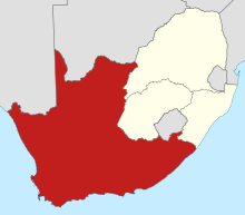
The Province of the Cape of Good Hope[2] (Afrikaans: Provinsie van die Kaap die Goeie Hoop), commonly referred to as the Cape Province (Afrikaans: Kaapprovinsie) and colloquially as The Cape (Afrikaans: Die Kaap), was a province in the Union of South Africa and subsequently the Republic of South Africa. It encompassed the old Cape Colony, and had Cape Town as its capital. Following the end of the Apartheid era, the Cape Province was split up to form the new Eastern Cape, Northern Cape and Western Cape provinces, along with part of the North West.
History
When the Union of South Africa was formed in 1910, the original Cape Colony was renamed the Cape Province.
It was by far the largest of South Africa's four provinces, as it contained regions it had previously annexed, such as British Bechuanaland (not to be confused with the Bechuanaland Protectorate, now Botswana), Griqualand East (the area around Kokstad) and Griqualand West (area around Kimberley). As a result, it encompassed two-thirds of South Africa's territory, and covered an area similar in size to the US state of Texas.
At the time of the formation of the Union of South Africa, South Africa consisted of four provinces: Transvaal (South African Republic), Natal (Natalia Republic), Orange Free State and the Cape Province.
Cape Franchise
Before union, the Cape Colony had traditionally implemented a system of non-racial franchise, whereby qualifications for suffrage were applied equally to all males, regardless of race. During the union negotiations, the Cape Prime Minister, John X. Merriman fought unsuccessfully to extend this multi-racial franchise system to the rest of South Africa. This failed, as it was strongly opposed by the other constituent states which were determined to entrench white rule. After union, the Cape Province was permitted to keep a restricted version of its multi-racial qualified franchise, and thus became the only province where coloureds (mixed-race people) and Black Africans could vote.[3][4]
Over the following years, successive acts were passed to erode this colour-blind voters roll. In 1931, the restricting franchise qualifications were removed for white voters, but kept for Black and Coloured voters.[5] In 1956, the Apartheid government removed all remaining suffrage rights for "non-whites". The government had to appoint many extra senators in parliament to force through this change. [6]
Partitioning under Apartheid
During the apartheid era the country was divided into a number of additional pieces which were known as the four TBVC States and the six Non-Independent Homelands. These were created by the apartheid government to enforce its policy of racial segregation.
Griqualand East was transferred to Natal Province after the Transkei was declared independent, since it was cut off from the rest of the province. The Transkei (1976) and Ciskei (1981) regions were declared independent of South Africa, after they were formerly part of the Cape Province. (They were re-incorporated into South Africa in 1994, both part of the new Eastern Cape province).[7]
Post Apartheid history
After the first fully democratic elections in 1994, these "bantustans" were reunited with the rest of the country, which was then divided into what are now the current nine provinces of South Africa.
The Cape Province was broken up into three smaller provinces: the Western Cape, Eastern Cape and Northern Cape. Parts of it were also absorbed into the North West. Walvis Bay, a territory of the original Cape Colony, was ceded to Namibia.
Districts in 1991
Districts of the province and population at the 1991 census.[1]
- Aberdeen: 8,009
- Adelaide: 15,220
- Albany: 69,705
- Albert (main town Burgersdorp): 16,995
- Alexandria: 26,651
- Aliwal-Noord: 27,486
- Barkly-Oos: 12,821
- Barkly-Wes: 35,012
- Bathurst: 32,419
- Beaufort-Wes: 31,726
- Bedford: 16,074
- Bellville: 269,995
- Bredasdorp: 23,076
- Britstown: 6,523
- Caledon: 79,052
- Calitzdorp: 6,759
- Calvinia: 18,430
- Cape: 179,537
- Carnarvon: 9,728
- Cathcart: 14,815
- Ceres: 47,052
- Clanwilliam: 28,144
- Colesberg: 15,446
- Cradock: 37,144
- De Aar: 25,438
- Oos-Londen: 240,474
- Elliot: 14,159
- Fort Beaufort: 22,793
- Fraserburg: 4,367
- George: 95,597
- Goodwood: 259,620
- Gordonia (main town Upington):[8] 118,623
- Graaff-Reinet: 34,440
- Hankey: 24,548
- Hanover: 4,399
- Hartswater: 29,146
- Hay (main town Griquatown):[9] 11,104
- Heidelberg: 11,519
- Herbert (main town Douglas):[10] 26,316
- Hermanus: 21,610
- Hofmeyr: 4,995
- Hopefield: 8,822
- Hopetown: 11,175
- Humansdorp: 43,799
- Indwe: 9,483
- Jansenville: 9,797
- Joubertina: 13,385
- Kenhardt: 11,353
- Kimberley: 167,060
- King William's Town: 29,653
- Kirkwood: 30,766
- Knysna: 50,420
- Komga: 14,142
- Kuilsrivier: 133,577
- Kuruman: 24,817
- Ladismith: 12,705
- Lady Grey: 7,530
- Laingsburg: 5,781
- Maclear: 16,653
- Malmesbury: 113,450
- Middelburg: 21,737
- Molteno: 11,702
- Montagu: 21,674
- Moorreesburg: 11,159
- Mosselbaai: 59,170
- Murraysburg: 5,960
- Namakwaland (main town Springbok): 62,536
- Noupoort: 8,348
- Oudtshoorn: 68,093
- Paarl: 136,121
- Pearston: 4,983
- Philipstown: 8,799
- Piketberg: 34,152
- Port Elizabeth: 670,653
- Postmasburg: 54,790
- Prieska: 19,185
- Prince Albert: 8,567
- Queenstown: 44,469
- Richmond: 6,326
- Riversdal: 25,021
- Robertson: 32,331
- Simonstad: 58,323
- Somerset-Oos: 29,758
- Somerset-Wes: 59,947
- Stellenbosch: 73,839
- Sterkstroom: 7,687
- Steynsburg: 10,593
- Steytlerville: 5,341
- Strand: 40,096
- Stutterheim: 40,119
- Sutherland: 3,596
- Swellendam: 32,147
- Tarka: 9,538
- Tulbagh: 25,334
- Uitenhage: 182,551
- Uniondale: 9,354
- Vanrhynsdorp: 12,815
- Venterstad: 5,777
- Victoria West: 11,910
- Vredenburg: 39,908
- Vredendal: 28,962
- Vryburg: 98,551
- Walvisbaai (South African 1878–1994): 22,999
- Warrenton: 22,368
- Wellington: 37,432
- Williston: 4,177
- Willowmore: 10,734
- Wodehouse (main town Dordrecht):[11] 15,540
- Worcester: 117,159
- Wynberg: 1,101,668
Administrators
See also
References
- 1 2 "Census > 1991 > RSA > Variable Description > Person file > District code". Statistics South Africa – Nesstar WebView. Retrieved 18 August 2013.
- ↑ South Africa Act, 1909 §6 (Wikisource)
- ↑ http://www.eisa.org.za/WEP/souoverview5.htm
- ↑ "Archived copy" (PDF). Archived from the original (PDF) on 17 May 2006. Retrieved 6 July 2012.
- ↑ http://www.eisa.org.za/WEP/soubg2.htm
- ↑ Christoph Marx: Oxwagon Sentinel: Radical Afrikaner Nationalism and the History of the Ossewabrandwag. LIT Verlag Münster, 2009. p.61.
- ↑ "The Homelands". South African History Online. Retrieved 31 December 2017.
- ↑ "Dictionary of Southern African Place Names (Public Domain)". Human Science Research Council. p. 182.
- ↑ "Dictionary of Southern African Place Names (Public Domain)". Human Science Research Council. p. 200.
- ↑ "Dictionary of Southern African Place Names (Public Domain)". Human Science Research Council. p. 205.
- ↑ "Dictionary of Southern African Place Names (Public Domain)". Human Science Research Council. p. 478.
External links
| Wikisource has the text of the 1911 Encyclopædia Britannica article Cape Colony. |
| Provinces of South Africa | .svg.png) | |
|---|---|---|
| Non-independent homelands | ||
| Independent homelands1 | ||
| Dependent territories | ||
| ||