List of municipalities in Nova Scotia
Nova Scotia is the seventh-most populous province in Canada with 923,598 residents as of the 2016 Census of Population, and the second-smallest province in land area at 52,942 km2 (20,441 sq mi).[1] Nova Scotia's 50 municipalities cover 99.8% of the territory's land mass, and are home to 98.9% of its population.[lower-alpha 1][2]
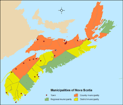
Unlike the provinces of British Columbia, Ontario and Quebec, which have two-tiered municipality systems, Nova Scotia has a one-tier system of municipalities[3] inclusive of four municipality types – regional municipalities, towns, county municipalities and district municipalities.[4] Regional municipalities may incorporate under the Municipal Government Act (MGA) of 1998, which came into force on April 1, 1999,[5] while towns, county municipalities and district municipalities are continued as municipalities under the MGA.[6] The MGA gives municipal councils the power to make bylaws for "health, well being, safety and protection of persons" and "safety and protection of property" in addition to a few expressed powers.[7]
Of its 50 municipalities, Nova Scotia has 3 regional municipalities, 26 towns, 9 county municipalities and 12 district municipalities.[4] Halifax, the provincial capital, is incorporated as a regional municipality. It is Nova Scotia's largest municipality by population with 403,131 residents as of the 2016 census and largest municipality by land area at 5,490.35 km2 (2,119.84 sq mi).[2]
Municipalities
Regional municipalities
Regional municipalities are incorporated under the authority of section 372 of Nova Scotia's Municipal Government Act. To consider the incorporation of a regional municipality, the Nova Scotia Utility and Review Board (NSUARB) must receive a request from all municipalities within a county. If the request is unanimous, the NSUARB commissions the preparation of a study to determine if the incorporation of "a regional municipality would be in the interests of the people of the county." Nova Scotia's Governor in Council can order the incorporation of a regional municipality if the results of the study are deemed to be in the best interests of the people, and if a plebiscite is undertaken that results in the majority of electors in the county voting in favour of incorporation of a regional municipality.[6]
Nova Scotia has three regional municipalities. The largest regional municipality by population is Halifax, which is the capital and largest municipality of Nova Scotia by population. Halifax's 403,131 residents represent 44% of the total population of the province. Halifax is also the largest municipality by land area at 5,490.35 km2 (2,119.84 sq mi). The Region of Queens Municipality is Nova Scotia's smallest regional municipality both by population and land area at 10,307 residents and 2,392.63 km2 (923.80 sq mi) respectively.[2]
Rural municipalities
A rural municipality in Nova Scotia provides local government for rural areas outside incorporated towns. Rural municipalities were established in 1879 and are inclusive of county municipalities and district municipalities. District municipalities are within historical counties that were previously subdivided into districts, whereas county municipalities are within historical counties that were not previously subdivided into districts.[8]
County municipalities
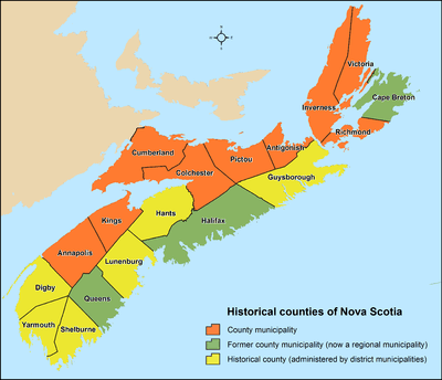
Nova Scotia's county municipalities originate from a historical system of 18 counties.[9] Prior to the establishment of rural municipalities in 1879, local government was administered by appointed courts of sessions.[8] On April 17, 1879, the original non-elected courts of sessions were abolished in favour of elected councils when The County Incorporation Act came into force.[8] As a result, 12 county municipalities were established, while the remaining 6 counties, which were previously divided into districts for court sessional purposes, were established as district municipalities.[8]
The province had 12 county municipalities for over a century until the mid-1990s when 3 became regional municipalities.[10] Its 9 remaining county municipalities were then continued as county municipalities in 1998 under the authority of the Municipal Government Act.[6] These county municipalities provide local government to the residents of their historical counties who live outside incorporated towns.[8]
Nova Scotia's largest county municipality by population is the Municipality of the County of Kings at 47,404 residents, while the largest by land area is the Municipality of the County of Cumberland at 4,255.04 km2 (1,642.88 sq mi). The Municipality of the County of Victoria is the least populated county municipality at a population of 6,552. The Municipality of the County of Richmond is Nova Scotia's smallest county municipality by land area at 1,243.72 km2 (480.20 sq mi).[2]
District municipalities
Prior to the establishment of elected rural local government in Nova Scotia, 6 of the 18 historical counties were divided into districts for court sessional purposes.[8] On April 17, 1879, these 6 historical counties were established as 12 district municipalities, rather than county municipalities, based on their previous district divisions.[8] The district municipalities provide local government to the residents of the 6 historical counties who live outside incorporated towns.[8] Nova Scotia's 12 district municipalities continue administratively as district municipalities under the authority of the Municipal Government Act of 1998.[6]
Nova Scotia's largest and smallest district municipalities by population are Lunenburg and St. Mary's with 24,863 and 2,233 residents respectively.[2] Nova Scotia's largest district municipality by land area is Guysborough at 2,116.86 km2 (817.32 sq mi), while the smallest by land area is Yarmouth at 586.65 km2 (226.51 sq mi).[2]
Towns
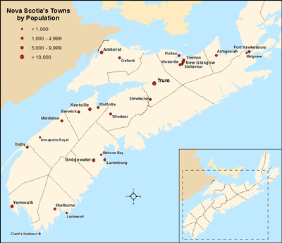
Prior to mid-2015, towns were incorporated under the authority of sections 383 through 388 of Nova Scotia's Municipal Government Act (MGA).[11] To incorporate an area as a town, 100 electors within the area were required to prepare and submit an application to the Nova Scotia Utility and Review Board (NSUARB).[11] Upon receiving the application, the NSUARB would undertake a hearing to solicit input from interested parties and determine if there were reasonable grounds to incorporate as a town.[11] The NSUARB would issue an incorporation order if the application was deemed reasonable.[11] On May 11, 2015, sections 383 through 388 of the MGA were repealed, thereby preventing further incorporations of towns.[12]
Nova Scotia had 27 towns at the time of the 2016 census.[2] This total has since been reduced to 26 due to the dissolution of the Town of Parrsboro.[13] In the 2016 census, the remaining 26 towns had a cumulative population of 97,495. Nova Scotia's largest and smallest towns by population are Truro and Annapolis Royal with 12,261 and 491 residents respectively.[2] These two towns are also Nova Scotia's largest and smallest by land area at 34.49 km2 (13.32 sq mi) and 2.04 km2 (0.79 sq mi) respectively.[2]
List of municipalities
 Halifax is Nova Scotia's capital and largest municipality by population.
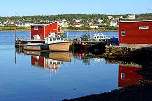 Harbour of Louisbourg in Cape Breton, Nova Scotia's second-most populated municipality
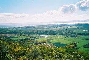 The Municipality of the County of Kings is Nova Scotia's largest county municipality by population.
| Municipal type | Incorporation date[14] |
2016 Census of Population[2] | |||||
|---|---|---|---|---|---|---|---|
| Population (2016) |
Population (2011) |
Change |
Land area (km²) |
Population density | |||
| Cape Breton | Regional municipality | August 1, 1995 | 94,285 | 97,398 | −3.2% | 2,430.06 | 38.8/km2 |
| Halifax | Regional municipality | April 1, 1996 | 403,131 | 390,086 | +3.3% | 5,490.35 | 73.4/km2 |
| Queens | Regional municipality | April 1, 1996 | 10,307 | 10,917 | −5.6% | 2,392.63 | 4.3/km2 |
| Annapolis[lower-alpha 2] | County municipality | April 17, 1879 | 18,252 | 18,526 | −1.5% | 3,178.21 | 5.7/km2 |
| Antigonish[lower-alpha 3] | County municipality | April 17, 1879 | 14,584 | 14,692 | −0.7% | 1,450.27 | 10.1/km2 |
| Colchester[lower-alpha 4] | County municipality | April 17, 1879 | 36,091 | 36,624 | −1.5% | 3,572.49 | 10.1/km2 |
| Cumberland[lower-alpha 5] | County municipality | April 17, 1879 | 19,402 | 20,485 | −5.3% | 4,255.04 | 4.6/km2 |
| Inverness[lower-alpha 6] | County municipality | April 17, 1879 | 13,190 | 13,781 | −4.3% | 3,815.59 | 3.5/km2 |
| Kings[lower-alpha 7] | County municipality | April 17, 1879 | 47,404 | 47,569 | −0.3% | 2,094.05 | 22.6/km2 |
| Pictou[lower-alpha 8] | County municipality | April 17, 1879 | 20,692 | 21,278 | −2.8% | 2,797.25 | 7.4/km2 |
| Richmond[lower-alpha 9] | County municipality | April 17, 1879 | 8,458 | 8,812 | −4.0% | 1,243.72 | 6.8/km2 |
| Victoria[lower-alpha 10] | County municipality | April 17, 1879 | 6,552 | 6,597 | −0.7% | 2,854.01 | 2.3/km2 |
| Argyle | District municipality | align=center| April 17, 1879 | 7,899 | 8,252 | −4.3% | 1,528.17 | 5.2/km2 |
| Barrington | District municipality | align=center| April 17, 1879 | 6,646 | 6,994 | −5.0% | 632.35 | 10.5/km2 |
| Chester | District municipality | align=center| April 17, 1879 | 10,310 | 10,599 | −2.7% | 1,122.11 | 9.2/km2 |
| Clare | District municipality | align=center| April 17, 1879 | 8,018 | 8,319 | −3.6% | 852.55 | 9.4/km2 |
| Digby | District municipality | align=center| April 17, 1879 | 7,107 | 7,463 | −4.8% | 1,657.33 | 4.3/km2 |
| East Hants | District municipality | align=center| April 17, 1879 | 22,453 | 22,111 | +1.5% | 1,786.56 | 12.6/km2 |
| Guysborough | District municipality | align=center| April 17, 1879 | 4,670 | 4,995 | −6.5% | 2,116.86 | 2.2/km2 |
| Lunenburg | District municipality | align=center| April 17, 1879 | 24,863 | 25,118 | −1.0% | 1,759.59 | 14.1/km2 |
| Shelburne | District municipality | align=center| April 17, 1879[8] | 4,288 | 4,408 | −2.7% | 1,821.07 | 2.4/km2 |
| St. Mary's | District municipality | align=center| April 17, 1879 | 2,233 | 2,354 | −5.1% | 1,909.47 | 1.2/km2 |
| West Hants | District municipality | align=center| April 17, 1879 | 15,368 | 15,324 | +0.3% | 1,244.09 | 12.4/km2 |
| Yarmouth | District municipality | align=center| April 17, 1879[8] | 9,845 | 10,105 | −2.6% | 586.65 | 16.8/km2 |
| Amherst | Town | December 18, 1889 | 9,413 | 9,717 | −3.1% | 12.07 | 779.9/km2 |
| Annapolis Royal | Town | November 29, 1892 | 491 | 481 | +2.1% | 2.04 | 240.7/km2 |
| Antigonish | Town | January 9, 1889 | 4,364 | 4,524 | −3.5% | 5.01 | 871.1/km2 |
| Berwick | Town | May 25, 1923[15] | 2,509 | 2,454 | +2.2% | 6.58 | 381.3/km2 |
| Bridgewater | Town | February 13, 1899 | 8,532 | 8,241 | +3.5% | 13.63 | 626.0/km2 |
| Clark's Harbour | Town | March 4, 1919 | 758 | 820 | −7.6% | 2.81 | 269.8/km2 |
| Digby | Town | December 18, 1890 | 2,060 | 2,152 | −4.3% | 3.15 | 654.0/km2 |
| Kentville | Town | May 1, 1886 | 6,271 | 6,094 | +2.9% | 17.26 | 363.3/km2 |
| Lockeport | Town | February 26, 1907 | 531 | 588 | −9.7% | 2.33 | 227.9/km2 |
| Lunenburg | Town | October 29, 1888 | 2,263 | 2,313 | −2.2% | 4.04 | 560.1/km2 |
| Mahone Bay | Town | March 31, 1919 | 1,036 | 943 | +9.9% | 3.12 | 332.1/km2 |
| Middleton | Town | May 31, 1909 | 1,832 | 1,749 | +4.7% | 5.57 | 328.9/km2 |
| Mulgrave | Town | December 1, 1923 | 722 | 794 | −9.1% | 17.83 | 40.5/km2 |
| New Glasgow | Town | May 6, 1875 | 9,075 | 9,562 | −5.1% | 9.96 | 911.1/km2 |
| Oxford | Town | April 19, 1904 | 1,190 | 1,151 | +3.4% | 10.76 | 110.6/km2 |
| Pictou | Town | May 4, 1874 | 3,186 | 3,437 | −7.3% | 8.01 | 397.8/km2 |
| Port Hawkesbury | Town | January 22, 1889 | 3,214 | 3,366 | −4.5% | 8.1 | 396.8/km2 |
| Shelburne | Town | April 4, 1907[16] | 1,743 | 1,686 | +3.4% | 8.84 | 197.2/km2 |
| Stellarton | Town | October 22, 1889 | 4,208 | 4,485 | −6.2% | 8.99 | 468.1/km2 |
| Stewiacke | Town | August 30, 1906 | 1,373 | 1,438 | −4.5% | 17.62 | 77.9/km2 |
| Trenton | Town | March 18, 1911 | 2,474 | 2,616 | −5.4% | 6.07 | 407.6/km2 |
| Truro | Town | May 6, 1875 | 12,261 | 12,059 | +1.7% | 34.49 | 355.5/km2 |
| Westville | Town | August 20, 1894 | 3,628 | 3,798 | −4.5% | 14.23 | 255.0/km2 |
| Windsor | Town | April 4, 1878 | 3,648 | 3,785 | −3.6% | 9.11 | 400.4/km2 |
| Wolfville | Town | March 4, 1893 | 4,195 | 4,269 | −1.7% | 6.46 | 649.4/km2 |
| Yarmouth | Town | August 6, 1890 | 6,518 | 6,761 | −3.6% | 10.57 | 616.7/km2 |
| Total regional municipalities | — | — | 507,723 | 498,401 | +1.9% | 10,313.04 | 49.2/km2 |
| Total county municipalities | — | — | 184,625 | 188,364 | −2.0% | 25,260.63 | 7.3/km2 |
| Total district municipalities | — | — | 123,700 | 126,042 | −1.9% | 17,016.8 | 7.3/km2 |
| Total towns | — | — | 97,495 | 99,283 | −1.8% | 248.65 | 392.1/km2 |
| Total municipalities | — | — | 913,543 | 912,090 | +0.2% | 52,839.12 | 17.3/km2 |
| Province of Nova Scotia | — | — | 923,598 | 921,727 | +0.2% | 52,942.27 | 17.45/km2 |
Former municipalities
Nova Scotia has undergone reforms to local government since the mid-1990s, which has seen various municipalities amalgamate to form larger municipalities or dissolve into surrounding municipalities.
Amalgamations
The Municipality of the County of Cape Breton, the City of Sydney, and the towns of Dominion, Glace Bay, Louisbourg, New Waterford, North Sydney, and Sydney Mines dissolved and amalgamated on April 1, 1995 to form the Cape Breton Regional Municipality. The City of Halifax along with the City of Dartmouth, the Town of Bedford and the Municipality of the County of Halifax also dissolved and amalgamated on April 1, 1996 to become the Halifax Regional Municipality. Also on April 1, 1996, the Municipality of the County of Queens amalgamated with the Town of Liverpool to form the Region of Queens Municipality.[10]
Dissolutions
Five towns have dissolved since 2011 and are now under the jurisdiction of their adjacent rural municipalities. Canso dissolved on July 1, 2012 to become part of the Municipality of the District of Guysborough.[4] On April 1, 2015, Bridgetown and Springhill dissolved to become parts of the Municipality of the County of Annapolis and the Municipality of the County of Cumberland respectively.[4] Hantsport became part of the Municipality of the District of West Hants on July 1, 2015.[4] Parrsboro dissolved to become part of the Municipality of the County of Cumberland on November 1, 2016.[13]
See also
Notes
- ↑ The remaining 1.1% of Nova Scotia's population resides on Indian reserves, which occupy the remaining 0.2% of the province's land mass.[2]
- ↑ Population and land area figures for the Municipality of the County of Annapolis are derived from summing the census results for its four county subdivisions (A, B, C and D).[2]
- ↑ Population and land area figures for the Municipality of the County of Antigonish are derived from summing the census results for its two county subdivisions (A and B).[2]
- ↑ Population and land area figures for the Municipality of the County of Colchester are derived from summing the census results for its three county subdivisions (A, B and C).[2]
- ↑ Population and land area figures for the Municipality of the County of Cumberland are derived from summing the census results for its four county subdivisions (A, B, C and D) and the dissolved Town of Parrsboro.[2]
- ↑ Population and land area figures for the Municipality of the County of Inverness are derived from summing the census results for its three county subdivisions (A, B and C).[2]
- ↑ Population and land area figures for the Municipality of the County of Kings are derived from summing the census results for its four county subdivisions (A, B, C and D).[2]
- ↑ Population and land area figures for the Municipality of the County of Pictou are derived from summing the census results for its three county subdivisions (A, B and C).[2]
- ↑ Population and land area figures for the Municipality of the County of Richmond are derived from summing the census results for its three county subdivisions (A, B and C).[2]
- ↑ Population and land area figures for the Municipality of the County of Victoria are derived from summing the census results for its two county subdivisions (A and B).[2]
References
- ↑ "Population and dwelling counts, for Canada, provinces and territories, 2016 and 2011 censuses – 100% data". Statistics Canada. February 8, 2017. Retrieved February 11, 2017.
- 1 2 3 4 5 6 7 8 9 10 11 12 13 14 15 16 17 18 19 20 "Population and dwelling counts, for Canada, provinces and territories, and census subdivisions (municipalities), 2016 and 2011 censuses – 100% data (Nova Scotia)". Statistics Canada. February 8, 2017. Retrieved February 11, 2017.
- ↑ Gonzalo Pineros (2015). "Upper Tier and Lower Tier Municipality Integration to Collaboratively Address Population Growth, Aging Infrastructure and Climate Change" (PDF). McMaster University. p. 7. Retrieved December 28, 2016.
The Canadian provinces of Ontario, Quebec and British Columbia have two-tier municipality systems.
- 1 2 3 4 5 "Nova Scotia Annual Report of Municipal Statistics for the fiscal year ended March 31, 2015" (PDF). Department of Municipal Affairs. 2015. p. 12. Retrieved December 5, 2016.
- ↑ "Municipal History Highlights". Province of Nova Scotia Department of Municipal Affairs. October 8, 2015. Retrieved December 8, 2016.
- 1 2 3 4 "Municipal Government Act" (PDF). Office of the Legislative Counsel, Nova Scotia House of Assembly. June 19, 2012. Retrieved December 5, 2016.
- ↑ "Assessment of the Municipal Acts of the Provinces and Territories" (PDF). Federation of Canadian Municipalities. April 2004. p. 30. Retrieved December 5, 2016.
- 1 2 3 4 5 6 7 8 9 10 "The Establishment of Elective Rural Municipal Government in Nova Scotia" (PDF). Government of Nova Scotia: Department of Municipal Affairs. pp. 1, 2. Retrieved December 27, 2016.
- ↑ "History of County Boundaries". Province of Nova Scotia: Department of Municipal Affairs. October 8, 2015. Retrieved December 27, 2016.
- 1 2 "Nova Scotia Annual Report of Municipal Statistics for the fiscal year ended March 31, 2014" (PDF). Department of Municipal Affairs. 2014. p. 12. Retrieved December 5, 2016.
- 1 2 3 4 "Municipal Government Act, Part XVII: Municipal Incorporation". Office of the Legislative Counsel. April 22, 1999. Retrieved December 10, 2016.
- ↑ "Bill No. 103: An Act to Amend Chapter 18 of the Acts of 1998, the Municipal Government Act" (PDF). Government of Nova Scotia. May 11, 2015. Retrieved December 29, 2016.
- 1 2 "Decision 2016 NSUARB 100 – M07110". Nova Scotia Utility and Review Board. June 15, 2016. Retrieved January 18, 2017.
- ↑ "Municipal Incorporation Timeline". Province of Nova Scotia. Retrieved December 6, 2016.
- ↑ Canadian Almanac & Directory. Scobie & Balfour. 2010. ISBN 1592374395.
- ↑ "Shelburne's History: Settlement of Shelburne". Town of Shelburne. Retrieved January 2, 2017.
It was incorporated as a town on April 4, 1907.
External links
- Municipal – Provincial Relationships
- Nova Scotia Department of Municipal Affairs
- Union of Nova Scotia Municipalities
| Historical counties | |
|---|---|
| Economic regions | |
| Regional municipalities | |
| County municipalities | |
| District municipalities | |
| Towns | |
| Villages | |
| Lists | |
| |
| Provinces | |
|---|---|
| Territories | |
| |