Vennbahn
The Vennbahn (German pronunciation: [ˈfɛnbaːn], "Fen Railway") is a former railway line that was built partly across what was then German territory by the Prussian state railways. It is now entirely in Belgium, because the trackbed of the line, as well as the stations and other installations, were made provisional Belgian territory in 1919 (permanent in 1922) under an article of the Treaty of Versailles.
This had the effect of creating six small exclaves of Germany on the line's western side,[1] of which five remain. The treaty (not the location of the trackbed, per se) also created one small Belgian counter-enclave, a traffic island inside a three-way German road intersection near Fringshaus.
The route is now a cycle way.[2]
Route
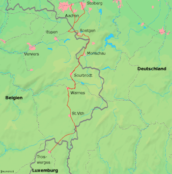
The line, which was standard gauge, ran for some 75 kilometres (47 mi) across the High Fens (Hautes Fagnes, Hohes Venn) to the south of Aachen in a roughly southward direction from Eupen via Raeren (the site of the depot), Monschau (Montjoie) and Malmedy to Trois-Ponts, with a 20 km (12 mi) eastward branch from Oberweywertz to Bütgenbach and Losheim. At Eupen it connected with the line to Herbesthal where it joined the Brussels-Cologne main line. At Trois-Ponts it connected with the Liège-Luxembourg line.
History
The line was built to carry coal and iron. The section of the line from Aachen to Monschau was opened on 30 June 1885. The section from Raeren to Eupen was opened on 3 August 1887. The link to Walheim was opened on 21 December 1889.[3]
On 18 May 1940 Adolf Hitler ordered that the area be re-annexed by the German Reich and the Vennbahn was returned to service as a wholly German line on 2 June 1940. However, after the defeat of Germany in 1945, the pre-war situation was re-instated.[4]
Operation
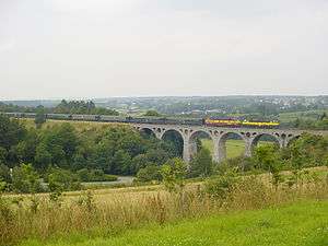
In latter years, until the end of 2001, the Vennbahn line operated tourist services, some of which were steam-hauled. These were withdrawn for want of funds to maintain the line. Part of the track between Kalterherberg and Sourbrodt is now used by railbikes.[5]
It was reported in 2008 that, with the Vennbahn no longer operational, Belgium might have to return the land the line runs along on to Germany, which would result in the reunification of the exclaves with German territory.[6][7] However, the foreign ministries of Germany and Belgium have since confirmed that the trackbed, even though disused, will stay as Belgian territory and that the German exclaves will therefore remain.[8]
By December 4, 2007, the dismantling of the now disused line had started;[9] by September 2008, the track had been completely removed between Trois-Ponts and Sourbrodt.
Enclaves and exclaves
| Name[10][11] | Area | Exclave of | Enclaved by | Coordinates | Notes | |
|---|---|---|---|---|---|---|
| (km2) | (acres) | |||||
| Münsterbildchen | 1.826 | 451 | 50°39′36″N 6°11′24″E / 50.66000°N 6.19000°E | West of Vennbahn trackbed; northernmost German enclave, mainly home to industrial and warehouse businesses. | ||
| Roetgener Wald | 9.98 | 2,470 | 50°38′12″N 6°14′32″E / 50.63667°N 6.24222°E | Western part of Lammersdorf, southern part of Roetgen, and intervening forest (Forst Rötgen); west and south of Vennbahn trackbed. From 1922 to 1958, the center portion (between Grenzweg and a boundary with three turning points west of the Schleebach stream) was Belgian territory. Until 1949, the east-west road that connected the two outer (German) portions was also German territory; therefore, the German land formed one oddly shaped enclave (that also included the road to Konzen). In 1949, it was split into two enclaves when Germany ceded the roads to Belgium;[12] in 1958, Belgium returned the east-west road and also ceded the center section of the current enclave to Germany. | ||
| Rückschlag | 0.016 | 4.0 | 50°35′52″N 6°14′53″E / 50.59778°N 6.24806°E | Part of city of Monschau, west of Vennbahn trackbed; smallest German enclave, consisting of one inhabited house with a garden. | ||
| Mützenich | 12.117 | 2,994 | 50°33′54″N 6°13′5″E / 50.56500°N 6.21806°E | West of Belgium's Vennbahn trackbed. | ||
| Ruitzhof | 0.937 | 232 | 50°31′29″N 6°11′39″E / 50.52472°N 6.19417°E | Part of city of Monschau, west of Vennbahn trackbed; southernmost Vennbahn enclave after 1949 (when Belgium annexed the Hemmeres enclave). | ||
Former Vennbahn enclaves:
- Hemmeres, (1922–1949), surrounded by Belgian territory, was the sixth and southernmost of the Vennbahn enclaves created in 1922; it contained five households.[13] The railway suffered severe damage during World War II and was not rebuilt. It ceased being an enclave when Belgium annexed the entirety in 1949. Hemmeres was reintegrated into West Germany on 28 August 1958, by an agreement with Belgium.
- Roetgener Wald was two enclaves from 1949 to 1958. Unlike its present configuration, the German enclave in 1922 was smaller in area because the central portion (between Grenzweg and a boundary with three turning points west of the Schleebach stream) was Belgian territory.[14] Because the road connecting the two outer German portions (Highways 258/399) was German territory until 1949, the German land formed one enclave. The intersecting north-south road from Fringshaus to Konzen (now Highway B258, which has no connection to the Belgian road network[15]) was also part of the oddly shaped enclave. In 1949 Belgium annexed these roads, thus separating the enclave into two enclaves for the next nine years. In 1958 Belgium ceded the center section of territory to West Germany, in addition to returning the adjacent east-west connecting road.[16] This created one larger enclave in its present form. Highway B258 is the only portion of land that, once having been a part of the Roetgener Wald enclave, is now not within the enclave.
- Belgium had a counter-enclave located near Fringshaus (50°37′34.643″N 6°14′5.2″E / 50.62628972°N 6.234778°E) from 6 November 1922 until 23 April 1949, while Germany owned the connecting roads that were part of the Roetgener Wald enclave. These roads met at a traffic island north of Fringshaus, with the 2,279 m2 (0.563 acres) island itself being a part of Belgium. This counter-enclave was extinguished in 1949 when Belgium annexed the German roads that intersected at the traffic island. In 1958, when Belgium returned the east-west road to Germany, this traffic island also became part of the Roetgener Wald enclave.
References
- ↑ German exclaves in Belgium (the exact number varies according to source)
- ↑ "Vennbahn". Evnnbhan Cycle Route. Retrieved 30 March 2018.
- ↑ "The Vennbahn: Belgium's railway through Germany". avoe05. 2000-02-03. Retrieved 2009-02-25.
- ↑ "Vennbahn (German enclaves within Belgium)". Enclaves of the World. Retrieved 8 February 2013.
- ↑ Railbike des Hautes Fagnes (in German)
- ↑ Tagesschau.de: Belgien könnte Staatsgebiet an Deutschland verlieren (in German)
- ↑ Deutsche Presse-Agentur (2008-01-09). "Belgium may lose land to Germany due to disused railway line". Monsters and Critics. Archived from the original on 2008-02-10. Retrieved 2008-02-22.
- ↑ WDR.de (2008-01-10). "Belgien behält seine Exklaven in Deutschland". WDR.de. Retrieved 2008-03-09. (in German)
- ↑ Wallorail.be Archived 2008-04-01 at the Wayback Machine. (in French)
- ↑ Whyte, Brendan (2004). "En Territoire Belge et à Quarante Centimètres de la Frontière" An historical and documentary study of the Belgian and Dutch enclaves of Baarle-Hertog and Baarle-Nassau. The University of Melbourne, School of Anthropology, Geography and Environmental Studies. ISBN 0-7340-3032-0.
- ↑ Krogh, Jan. "Jan S. Krogh's Geosite: Enclaves and Exclaves". Retrieved 2013-02-21.
- ↑ Bartholomew, John (1955). The Times Atlas of the World. Belgium, Plate 61, V. III (Map). Houghton Mifflin Co. Boston London. Retrieved 2013-05-04.
- ↑ Vinokurov, Evgeny (2007). The Theory of Enclaves. Lexington Books, Lanham, MD.
- ↑ Bartholomew, John (1955). "The Times Atlas of the World. Belgium, Plate 61, V. III". Houghton Mifflin Co. Boston London. Retrieved 2013-05-04.
- ↑ "Vennbahn: Bahnhof Konzen/Fringshaus". Retrieved 2013-05-04.
- ↑ U.S. Department of State (30 June 1961). "International Boundary Study, Belgium-Germany Boundary" (PDF). Archived from the original (PDF) on 23 September 2003. Retrieved 2013-05-04.
External links
